Identification and Climatology of Alpine Pumping from a Regional Climate Simulation
 Maximilian Graf
 Meinolf Kossmann
 Kristina Trusilova1
  Gudrun Mühlbacher
- 1Deutscher Wetterdienst, Department of Climate and Environment Consultancy, Offenbach, Germany
- 2Faculty of Mathematics and Geography, Katholische Universität Eichstätt-Ingolstadt, Eichstätt, Germany
- 3Deutscher Wetterdienst, Department Climate and Environment Consultancy, München, Germany
The thermally driven circulation between the European Alps and the Alpine foreland—named Alpine pumping—occurs regularly under clear and calm weather conditions. While previous studies focused on the impact of Alpine pumping on moist convection and transport of air pollutants, this study was motivated by its ventilation effect for Munich, located about 50 km north of the Alps in undulating and only slightly inclined terrain, where local thermal circulations are weak. Hourly data from a reanalysis driven regional climate simulation with COSMO-CLM model for the period 1989–2008 were analyzed to identify days with Alpine pumping and to determine the mean diurnal characteristics of this regional thermal circulation. Four literature derived combinations of meteorological criteria were tested to identify days favorable for Alpine pumping from COSMO-CLM results. The first criterion selects days with a daily sum of solar radiation ≥20 MJ/m2 and has been used in an earlier observational study. On average 60 day/year are fulfilling the criterion in the model simulation, which compares well to the 67 day/year determined from observations. The other three criteria combinations consider a maximum wind velocity at 850 hPa, a maximum daily precipitation sum, and/or a maximum mean cloud cover. The mean annual number of selected days is lower for these criteria combinations and ranges between 20 and 52. Diurnal wind reversals occur on 77–81% of the selected days, depending on the criteria combination. The daily solar radiation sum of 20 MJ/m2 is only exceeded during April to September, while days satisfying the criteria combinations without the radiation threshold occur all year round. In agreement with observations, the simulated regional thermally driven wind field extends up to ~100 km north of the Alps with average near-surface wind speeds of 0.5–1.5 m/s in the Munich area. With increasing distance from the Alps, the diurnal cycle of Alpine pumping is delayed by up to 3 h. The simulated mean depth of the daytime inflow layer ranges between 500 and 1500 m, whereas the depth of the nocturnal outflow layer typically reaches up to a few hundred meters.
Introduction
Data from simultaneous aerological soundings in central Europe became increasingly available during the first decades of the twentieth century and led to the discovery of a regional, thermally driven wind system between the European Alps and its surroundings (Burger and Ekhart, 1937). The diurnally reversing mountain-plain wind system occurs under fair weather conditions due to the formation of a nocturnal thermal high and a daytime thermal low over the Alps that can be attributed to the energy exchanges at the elevated Alpine terrain surfaces (Hafner et al., 1987; Sturman and Wanner, 2001; Zardi and Whiteman, 2013). Due to its spatial extension the mountain-plain wind system reveals considerable inertia. E.g., onset times of wind reversals in the areas south of Munich are typically delayed up to a few hours relative to sunrise and sunset (Prügel, 1942).
The field campaign VERTIKATOR (“Vertikaler Austausch und Orographie”) was conducted to study the physical processes and the climatology of mountain-plain wind systems in the northern Black Forest (Barthlott et al., 2006; Meißner et al., 2007) and in the German Alpine area (Corsmeier et al., 2003; Lugauer and Winkler, 2005; Weissmann et al., 2005). In the pre-alpine area of Bavaria (Germany), it was found that the mountain-plain wind system propagates about 100 km into the Alpine foreland (Lugauer and Winkler, 2005). The depth of the inflow layer often reaches 1000 m or more during the afternoon (Corsmeier et al., 2003; Weissmann et al., 2005), whereas the depth of the nocturnal outflow layer is much shallower. Over Alpine slopes and in valleys the regional-scale thermal circulation is enhanced by local slope wind and valley wind systems. The thermal circulation that results from the superposition of these three thermal circulation systems has been named “Alpine pumping” (Lugauer and Winkler, 2005). Spatial scales and patterns of the thermal circulations that contribute to Alpine pumping are shown schematically in Figure 1 for both daytime and nighttime. Lifting of the inflowing air during daytime and sinking of the outflowing air during nighttime is favored over slopes, valley heads and over the main divide of the Alps. Anti-winds (recirculation) aloft are much weaker than winds in the surface bound branches of Alpine pumping and often obscured by synoptic scale winds (McGowan, 2004).
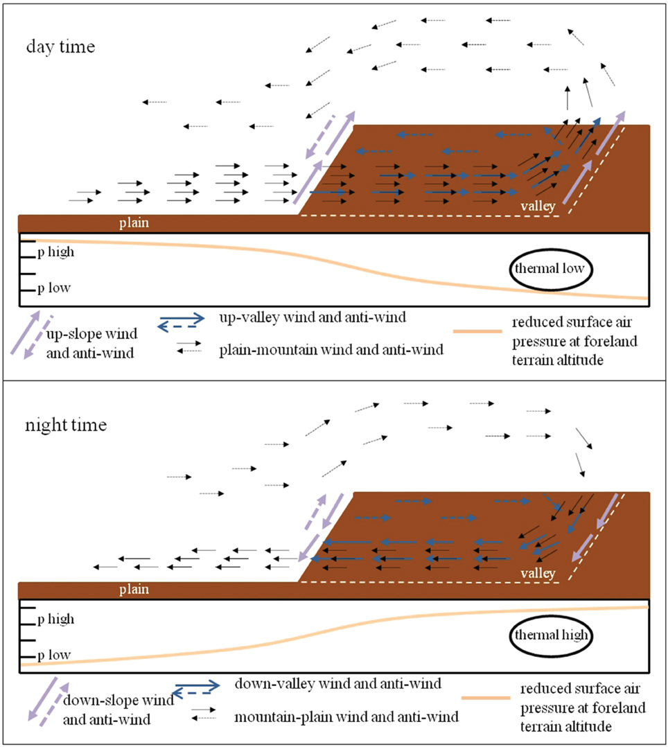
Figure 1. Schematic figure of the different wind systems combining to Alpine pumping with an idealized line of surface air pressure reduced to the altitude of the foreland.
In other mountain ranges around the globe similar regional scale mountain-plain wind systems have been observed. Examples are the Rocky Mountains (Zardi and Whiteman, 2013), Central Japan (Kurita et al., 1990; Kuwagata et al., 1990), and the Southern Alps of New Zealand (Sturman and Wanner, 2001). The regional scale mountain-plain wind systems in these areas have been studied to investigate the transport of air pollutants, boundary layer growth, and thunderstorm development (Kurita et al., 1990; Kuwagata et al., 1990; Lugauer and Winkler, 2005). This study investigates the characteristics and occurrence frequency for a better understanding of Alpine pumping and its importance for the urban environment of Munich, which is located about 50 km north of the European Alps in a slightly undulating terrain. During synoptically calm high pressure conditions, Alpine pumping can potentially alleviate the urban heat island by advection of cool rural air into the city. This is illustrated in Figure 2 which shows surface observations taken during fair weather conditions on 18 July 2014 in Munich City and at two rural stations located about 30 km north (Munich Airport) and south (Königsdorf, at a glider airfield) of Munich (see Figure 3). The stations in Munich City (WMO ID# 10865, 515 m asl) and at Munich Airport (WMO ID# 10870, 445 m asl) belong to the operational German weather station network, while the station at the glider airfield in Königsdorf (600 m asl) is only temporarily operated. Air temperature measurements at all 3 stations are taken at 2 m above ground level. Wind measurements in Munich City are taken at 28.5 m above ground level with wind sensors mounted on a mast 9 m above the roof. The Munich wind observations show a clear diurnal cycle of Alpine pumping with an abrupt transition to northeasterly winds in the morning, a more gradual transition to southeasterly in the evening, and southwesterly winds later in the night. Wind speed varied between 1.5 and 2.5 m/s during daytime and between 0.5 and 1.5 m/s during nighttime.
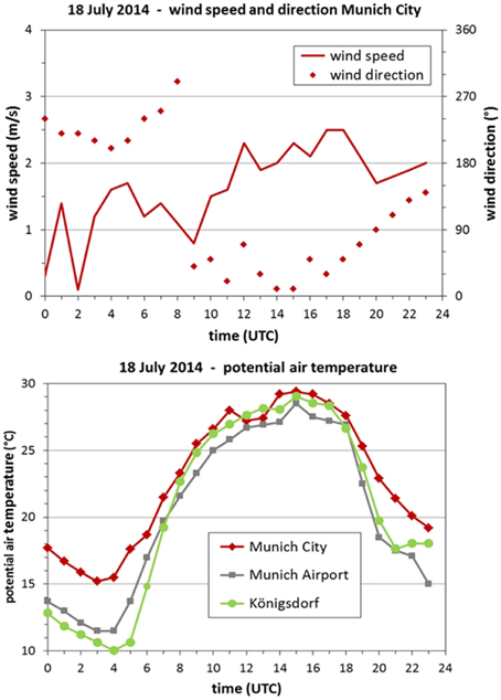
Figure 2. Surface station data measured on 18 July 2014. Wind speed and direction above roof level at the station Munich City located northwest of the historic downtown area (top) and potential air temperature 2 m above ground level at Munich City and at the two rural stations Munich Airport and Königsdorf (bottom). The station locations are shown in Figure 3.
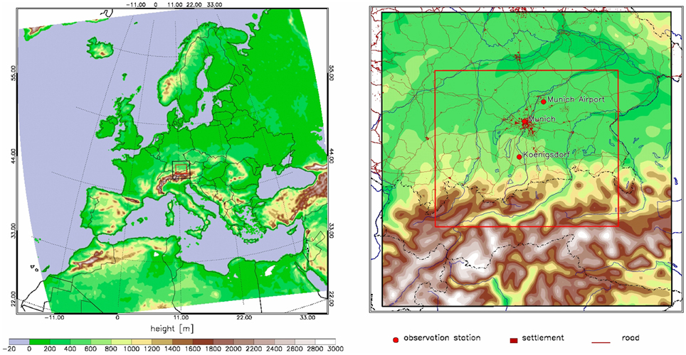
Figure 3. Model domains for EUROPE (left) and for MUNICH (right) nested into the Europe domain (location of the nest is shown by the black frame). The domain for the analysis of model results is shown by the red frame.
Potential temperatures calculated for the height of the station in Munich City (515 m asl) reveal a maximum urban heat island (UHI) intensity of about 5 K during the night while the daytime UHI intensity varied from +2 K to slightly negative values at noon (Figure 2). The cooling potential of Alpine pumping can be estimated using the temperature advection term ΔT/Δt = −v ΔT/Δy, where v is the typical southerly wind component near the surface, ΔT is the maximum UHI intensity and Δy is the approximate south-north distance of 5 km from the urban fringe to the city center. Applying the daytime values of |v| = 2 m/s and |ΔT| = 2 K and night time values of |v| = 1 m/s and |ΔT| = 5 K yields a magnitude of advective cooling of ~1.5 K per hour during daytime and ~3.5 K per hour during nighttime.
Motivated by this abundant impact of Alpine pumping on thermal conditions in Munich, this study uses a 20-year regional climate simulation to determine the characteristics and occurrence frequency of Alpine pumping in the northern foreland of the Alps. Section “Data and Methods” briefly describes the regional climate simulation used for this study and also the literature based criteria used for identification of days favorable for Alpine pumping. Model outputs for the identified days are used in Section “Results—Climatological Analysis of Alpine Pumping Days” to investigate the temporal and spatial characteristics at the surface and the vertical structure of Alpine pumping in the region around Munich. Section “Summary and Discussion” concludes with the main findings of the study.
Data and Methods
Model Setup COSMO-CLM
The mesoscale non-hydrostatic regional climate model COSMO-CLM (CCLM) (Rockel et al., 2008) used in this study was developed by an open international network of scientists of the Climate Limited-area Modeling-Community (CLM-community, www.clm-community.eu) from the original weather predicting model COSMO (Steppeler et al., 2003) of the German Meteorological Service (Deutscher Wetterdienst).
For simulations we use the well-tested reference version 4.8_clm19 of CCLM and setup a chain of two model domains—domain EUROPE with the spatial resolution of 0.11° (~12 km) with 40 vertical levels and domain MUNICH with the spatial resolution of 0.025° (~2.8 km) with 50 vertical levels and 110 × 112 horizontal grid cells nested into the domain EUROPE as shown Figure 3. The MUNICH domain extends from the foothills of the Swabian Mountains and the Bavarian Forest in the north to the southern side of the Alpine divide. The lowest model level is 20 m thick in both model domains. The period of simulation is 1989–2008. The initialization and constraining of the model domain EUROPE at the lateral boundaries is done with the ERA Interim Reanalysis dataset (Dee et al., 2011) available from the European Centre for Medium-Range Weather Forecasts (www.ecmwf.int). The nested domain MUNICH is forced at its boundaries by the output of the simulation for the domain EUROPE. For both model domains, the two-time level Runge-Kutta split-explicit scheme and the land surface model TERRA (Doms et al., 2011) with nine soil layers between 0.5, 2.5, 7, 16, 34, 70, 142, 286, 574, and 1150 cm are used. The land cover data classification of GLC2000 (Fritz et al., 2003) is used. Several large lakes are located south of Munich and at the foothills of the Alps. Land cover in this part of the domain is dominated by forest (see surface roughness map in Supplementary Material). The presented analysis of model results is limited to the central part of the nested domain (Figure 3).
Identification of Alpine Pumping Days
Criteria for Identification
Four literature-based combinations of meteorological criteria were tested to identify days favorable for Alpine pumping from COSMO-CLM results (Table 1). The data needed for application of all criteria are available from the hourly COSMO-CLM simulation output and in principle also from routine climate network observations. Radiation is seen as the main driving mechanism of Alpine pumping (Zaitchik et al., 2007). Therefore, a spatial mean daily sum of solar radiation ≥20 MJ/m2 in the model output analysis domain is defined as the first identification criterion (SR criterion). This threshold has previously been used in an observational study by Lugauer and Winkler (2005).
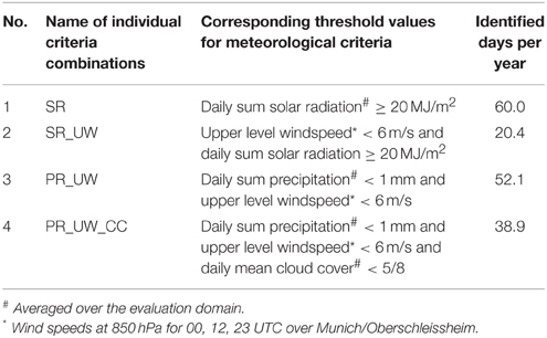
Table 1. Identification criteria combinations with threshold values and average yearly number of days identified from the COSMO-CLM simulation results for the period 1989-2008.
The second criteria combination also applies the SR criterion but excludes days with upper level wind speeds greater or equal to 6 m/s at 00, 12 or 23 UTC at 850 hPa (UW criterion). High ambient wind speeds (e.g., due to large-scale pressure systems), impede the evolution of the thermally driven winds (Kossmann et al., 2002; Stewart et al., 2002). The simulated 850 hPa wind velocity is extracted from model grid cells at Oberschleißheim (Coordinates: 48,17° N; 11,56° E) where radiosondes are operationally released by the German Meteorological Service twice a day at 12 and 00 UTC.
The other two criteria combinations are independent of radiation and can be seen as excluding criteria. During precipitation events, forcing of thermally driven winds is suppressed due to reduced sensible heat fluxes at the surface (Geiger et al., 1995). The third criteria combination interrelates the UW criterion with the exclusion of days with spatially averaged precipitation sum in the analysis domain >1 mm (PR criterion).
The fourth criteria combination applies a maximum cloud coverage threshold (CC criterion) in addition to the UW and PR criteria, as a proxy for solar radiation. The value of the total cloud coverage threshold averaged over the analysis domain was set to 5/8 in order to exclude days with a daily sum of solar radiation lower than 75% of the theoretical maximum radiation (Schafer et al., 1996).
In an alternative approach, a wind oscillation criterion, was applied to select days with outflow wind direction (between 120° and 240°) at 03:00 UTC, inflow wind direction (between 300° and 60°) at 13:00 UTC, and again outflow direction at 23:00 UTC. The regional climate model output for an area south of Munich (8 × 8 grid cells) was averaged over all days selected by the wind oscillation criterion. Results showed a mean daily solar radiation sum of ~18 MJ/m2, a mean 850 hPa wind velocity over Munich of about 6.5 m/s, a daily precipitation sum of about 1.5 mm, and a mean cloud cover between 4/8 and 5/8. These results give some confidence that the literature-based threshold values listed in Table 1 are appropriate to define favorable conditions for the Alpine pumping days. The wind oscillation criterion was also applied to the 4 subsets of days that fulfill the identification criteria combinations in Table 1 to determine the number (or percentage) of favorable days that individually reveal the diurnal wind reversal of interest.
Frequencies of Days Favorable for Alpine Pumping
On average 60 days per year fulfill the SR criterion in the model simulation (Table 1). This compares well to 67 days per year determined from observations by Lugauer and Winkler (2005). The mean annual number of selected days from the other three criteria combinations is lower and ranges between 20 and 52. Figure 4 illustrates how many criteria combinations select the same day during the 20-year period of the model simulation. Hit rates for all criteria combinations show a strong inter-annual variability, with years of high frequencies (e.g., 2003) and years with low frequencies (e.g., 1993) of days with favorable conditions for Alpine pumping. Overall, 25.9% of all days are selected by at least one of the four criteria combinations, but only about half of these days are selected by two, three or four criteria combinations.
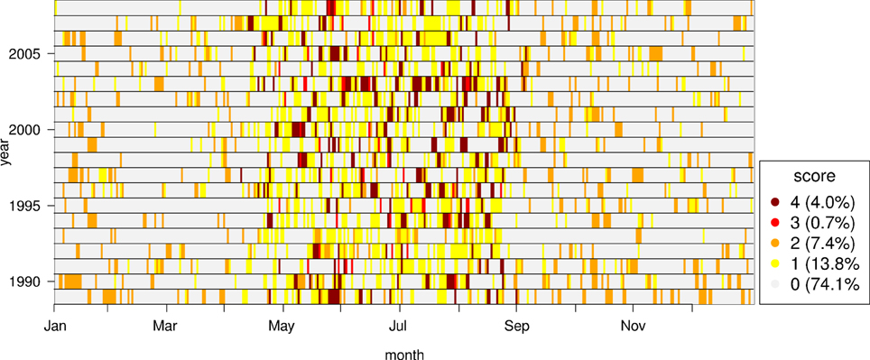
Figure 4. Daily score of the four criteria combinations defined in Table 1.
On one hand, the daily solar radiation sum of 20 MJ/m2 is only exceeded during the months from April to September with highest incidence frequencies from May to August. When the SR criterion is combined with the UW criterion, only one third of the SR criterion fulfilling days are selected (see Table 1). This finding indicates that on two thirds of the high-radiation days, the thermal wind systems are affected by moderate or strong synoptic winds.
On the other hand, days fulfilling the criteria combinations without a radiation threshold occur all year round. With fewer Alpine pumping days per year, these two criteria combinations appear stricter than the SR criterion, particularly during the warm season. Basically radiation-dependent criteria appear suitable to study the influences of Alpine pumping on urban heat load or photochemical smog events, while radiation-independent criteria combinations may be recommended to study its influence on air pollution problems that arise all year round (e.g., urban ventilation).
The hit rate of the wind oscillation criterion applied to all days and to the four subsets of days that fulfill the identification criteria combinations reveals a strong spatial variability. For the days preselected by the four identification criteria combinations, high hit rates between 75 and 85% are found in the area between Munich and the Alpine foothills. Analysis of 8 × 8 grid cells between Munich and the Alpine foothills (see Figure 5) shows that the wind oscillation criterion is fulfilled on 81% of the days that also fulfill the radiation criterion S or the combined S_UW criterion. For the days selected by the precipitation and upper level wind combination PR_UW and by the extended PR_UW_CC combination it is found that somewhat smaller fractions of 77 and 78% fulfill the wind oscillation criterion, respectively. When applied to all days, the hit rate of the wind oscillation criterion is 62 days per year.
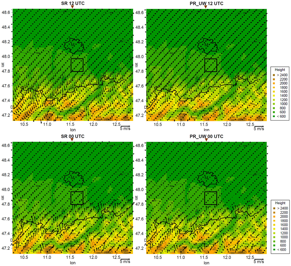
Figure 5. Averaged surface wind maps of the horizontal wind vector at 10 m agl for SR criterion (left) and PR_UW criteria combination (right) at 12 UTC (top) and 00 UTC (bottom). Bold black lines show the urban area of Munich (indicated by the letter M) and the German-Austrian border, while thin black contour lines represent the terrain height. 8 × 8 model grid points within the black rectangular frame (south of Munich) are used to calculate the wind oscillation criterion. The triangles at the top of the panels indicate the geographical longitude of the meridional cross sections shown in Figure 7.
The relatively high hit rates of the wind oscillation criterion suggest that Alpine pumping wind signatures have been largely captured by the four identification criteria combinations. In Section “Results—Climatological Analysis of Alpine Pumping Days,” the wind data from the selected days are used to analyze the mean temporal and spatial characteristics of Alpine pumping. Possible reasons for the gap between the high hit rates and 100% are discussed in Section “Summary and Discussion.”
Results—Climatological Analysis of Alpine Pumping Days
Hourly model outputs are used to calculate average wind fields for days selected by the four criteria combinations introduced in Section “Identification of Alpine Pumping Days.” Alpine pumping is found to be quite pronounced in the mean wind fields of all four criteria combinations, and its diurnal cycle has been identified by visual inspection of mean hourly surface wind maps and of mean hourly vertical cross sections of the wind field through Munich (Graf, 2014). Table 2 summarizes the mean diurnal phases of inflow, outflow, and flow transition. In agreement with Lugauer and Winkler (2005), the inflow phase is found to be shorter than the outflow phase, even for the radiation-dependent criteria that selects only days with longer daytime than nighttime duration. Due to the stronger variation in times of sunrise and sunset, the wind climatology for the radiation-independent criteria combinations reveals longer transition phases between inflow and outflow regimes.
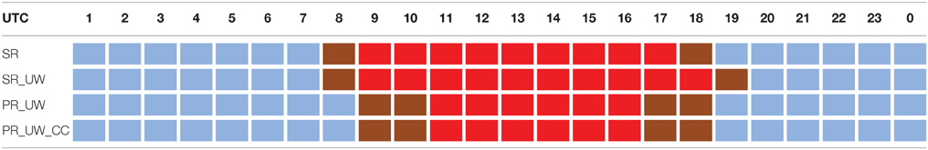
Table 2. Average times of inflow (red), outflow (blue), and transition (brown) phases of Alpine pumping derived from the mean hourly wind fields for the different criteria combinations.
Because of the similarity of the main findings and for brevity, detailed presentation and analysis of the mean wind fields in Sections “Temporal and Spatial Characteristics Near the Surface” and “Vertical Structure of Alpine Pumping” are limited to the SR criterion and the PR_UW criteria combination as representatives for radiation-dependent and radiation-independent selection criteria.
Temporal and Spatial Characteristics Near the Surface
Mean vectors of the wind field at 10 m above ground level (agl) at 00:00 UTC and 12:00 UTC are shown in Figure 5 for the days selected during the simulated 20-year period by the SR criterion and by the PR_UW criteria combination. Furthermore, latitude-time sections of the southerly surface wind component at the longitude of Munich (11.58°E), averaged over the selected days and 5 grid cells (ca. 14 km) in zonal direction are shown in Figure 6.
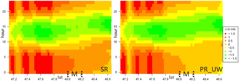
Figure 6. Latitude-time sections of the southerly surface wind component at the longitude of Munich, averaged over 5 grid cells in zonal direction for the SR criterion (left) and the PR_UW combination (right).
In agreement with observations, the simulated circulation extends up to the Danube Valley, located about 100 km north of the Alps (at the northern end of domain MUNICH). In the area of Munich (~48.15°N), average southerly wind speeds reach 0.5–1.0 m/s during nighttime and up to ~1.5 m/s during daytime (Figure 6). The magnitudes of these simulated wind speeds are similar to those observed on SR criterion days by Lugauer and Winkler (2005). Due to effects of local surface roughness and local orography the measured wind speeds exhibit a stronger spatial variability than wind speeds simulated on the 2.8 km model grid. The observational case study shown in Figure 2 suggests that wind speeds on days with ideal conditions can be at least 1 m/s higher than mean wind speeds for all selected days.
For the PR_UW criteria combination, Figure 6 shows that during nighttime southerly winds north of Munich are very weak (below 0.5 m/s), which is probably caused by stronger surface temperature inversions forming in the Danube valley during the cooler seasons at night time (Zängl, 2005). Daytime wind direction in the areas north of Munich gradually turns to northeasterly directions for both the SR criterion and the PR_UW criteria combination.
At the foothills and at valley exits of the Alps, the regional scale mountain-plain wind system is superimposed upon slope and valley wind systems. The simulated mean wind speeds are therefore stronger, locally reaching about 2.0 m/s during daytime and 2.5–3.0 m/s during nighttime (Figure 5). This behavior has also been analyzed by Lugauer and Winkler (2005), although local terrain effects on wind speed and direction at the measurement stations in this area are stronger than in the Alpine foreland.
With increasing distance from the Alps, the diurnal cycle of Alpine pumping is delayed by up to 3 h, as shown by the latitude-time sections of the southerly surface wind component in Figure 6. While the extension, surface wind velocity, and wind direction of Alpine pumping in the Alpine foreland agree well with observations by Lugauer and Winkler (2005), the quality of the simulated slope and valley wind systems is limited by the horizontal model resolution of 2.8 km.
Vertical Structure of Alpine Pumping
The vertical structure of the Alpine pumping layer is strongly related to the distance to the Alps and the time of the day (Figure 7). Analysis of meridional vertical cross sections of the simulated wind field through Munich show higher wind velocities close to the Alps (discussed in the previous Section “Temporal and Spatial Characteristics Near the Surface”) also extend to higher levels. Furthermore, the vertical cross sections confirm that wind reversals between the daytime and nighttime phases of Alpine pumping occur earlier in this region compared to the foreland. With greater distance from the Alps, the increasing time lag in wind reversal is evident in the entire inflow and outflow layer. The depth of the surface bound inflow and outflow layers are found to increase from north to south. Averaged winds above 2500 m reflect weak synoptic scale winds blowing mostly from northerly directions during days selected by the SR criterion and the PR_UW combination (Figure 7).
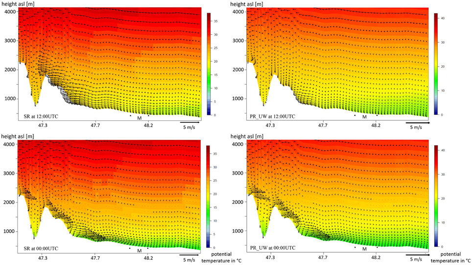
Figure 7. Averaged v and w wind components along a meridional vertical cross section through Munich at 12:00 UTC (top) and 00:00 UTC (bottom) for the SR criterion (left) and PR_UW combination (right), with potential temperature shown by color shading in the background. The two black dots mark the northern and southern border of Munich.
Due to this general upper level wind direction, the depth of the outflow layer can be detected more easily than the depth of inflow layer (Figure 7). At 00:00 UTC, the mean depth of the outflow layer reaches up to 400 m and wind speed in the outflow layer near the Alps reaches up to 3 m/s for both SR and PR_UW combination. High outflow wind velocities occur in two zones separated by weaker winds in between. One zone is located over the steepest north facing slopes of the Alps, where the regional scale mountain-plain winds are strongly enhanced by local down-slope winds. The second zone is located further north, about halfway between the Alps and Munich. Later in the night this second zone with high wind speeds moves northward and ceases before sunrise.
The mean simulated depth of the daytime inflow layer at 12:00 UTC is about 400 m for the PR_UW combination. With the SR combination, the mean depth is about 1000 m. The maximum depth can reach up to 700 m (PR_UW) and 1500 m (SR) respectively in the following 3 hours. For both combinations, the strongest winds occur over the foothills, and for the SR criterion, strong winds occur also over the north facing slopes of the Alps. Overall, stronger average insolation causes stronger inflow for the SR criterion with wind speeds up to 3 m/s, while the mean inflow velocity for the PR_UW combination is limited to about 1.5 m/s due to the inclusion of days with low insolation from the colder seasons.
The surface branch of the thermal circulation reveals a jet-like structure in wind velocity during both day and night. Jet heights are mostly between 30 and 150 m, but inflow jet heights for the SR criterion are somewhat higher, locally reaching 200–300 m agl.
Summary and Discussion
Hourly and daily data from a reanalysis-driven regional climate simulation with COSMO-CLM model for the period of 1989–2008 were analyzed to identify days with Alpine pumping and to determine the mean diurnal variation of the direction, intensity, and extension of the regional thermal circulation. The main findings are:
• The mean annual number of days with favorable conditions for Alpine pumping estimated by four criteria combinations varies between 20 and 60 days. A simple criterion requiring inflow and outflow conditions at certain times of the day identifies 62 days per year on average.
• For all four criteria combinations, the wind fields averaged over the selected days clearly reveal the expected diurnal cycle of Alpine pumping, with weak upper level (synoptic scale) winds from northeasterly directions.
• The days selected by the four identification criteria combinations were individually tested for occurrence of diurnal wind reversals using the wind oscillation criterion. For the area between Munich and the Alpine foothills, it is found that diurnal wind reversal occurs on 77–81% of the selected days, depending on the identification criteria combination.
• The mean annual number of 60 days found for the SR criterion compares well to the 67 days per year determined by the observational study of Lugauer and Winkler (2005).
• In agreement with Lugauer and Winkler (2005), the simulated regional thermal circulation extends from the Alps to the Danube Valley (located ca. 100 km north of the Alps).
• The simulated mean surface wind speed of Alpine pumping in the Munich area varies between 0.5 and 1.0 m/s during nighttime and reaches up to about 1.5 m/s during daytime. At the foothills and at valley exits of the Alps, the regional mountain-plain wind system is enhanced by slope and valley wind systems. Here the mean wind speed locally reaches about 2.0 m/s during daytime and 2.5–3.0 m/s during nighttime.
• Overall, the mean near surface wind speeds on selected days from the observational analysis (Lugauer and Winkler, 2005) and from the model results are of comparable magnitude. A more quantitative comparison is desirable in future studies, but requires the availability of regionalized wind observations, where effects of local surface roughness and local orography at the measurement stations have been removed or up-scaled to model grid resolution.
• In the Alpine foreland, the onset times for the inflow and outflow phases of Alpine pumping depend on the distance from the Alps. In comparison to locations at the foothills of the Alps the diurnal cycle north of Munich is delayed by up to 3 h.
• The simulated mean depth of the daytime inflow layer derived from meridional vertical cross sections of the wind field through Munich ranges between 500 and 1500 m, while the depth of the nocturnal outflow layer typically reaches up to a few hundred meters.
• The vertical cross sections reveal a jet structure in the thermal circulation between the Alps and the foreland with the highest wind speeds mostly at heights between 30 and 150 m agl, and higher daytime inflow jet heights of up to 200–300 m agl for the SR criterion.
From these findings it can be concluded that Alpine pumping is a frequently occurring phenomenon in the study area that provides significant ventilation under synoptically calm conditions. Cities located in the Alpine foreland strongly benefit from the advection of cold rural air provided by Alpine pumping under heat load conditions during both daytime and nighttime (see observational case study in Section “Introduction”).
In subsequent research, the presented COSMO-CLM model results will be used to drive simulations with the local scale urban climate model MUKLIMO_3 (Früh et al., 2011) under conditions with and without Alpine pumping. The model's horizontal grid spacing of 100 m and the detailed representation of urban boundary layer processes will allow a detailed analysis of the influences of Alpine pumping on summertime thermal conditions in Munich.
Despite the interesting outcomes, there are several limitations to the present study, and additional investigations are needed to improve understanding and climatological knowledge of Alpine pumping. E.g., not all the days identified by the four criteria combinations fulfill the wind oscillation criterion and the gap to 100% indicates that the data stratification used in this study for the identification of Alpine pumping days is clearly not perfect. Furthermore, the stricter criteria combinations of S_UW and PR_UW_CC do not provide higher hit rates for the wind oscillation criterion than the corresponding S and PR_UW criteria although they are showing a stronger signal of Alpine pumping in the mean wind fields. A reason for this could be that the applied wind oscillation criterion is too simplistic for the identification of the diurnal wind reversals of Alpine pumping and/or that the refinement of the identification criteria through upper level wind or cloud cover filters needs improvement. E.g., upper level wind effects are likely to be dependent on wind direction and upper level wind data at the 850 hPa level are possibly too high above the surface wind regime during night time when decoupling of surface winds often occurs at a few hundred meters above the surface.
There will be days when Alpine pumping is present but weak and hardly distinguishable from synoptic scale wind characteristics. Our study did not aim at identifying these days but rather intended to select days with moderate to strong intensities of the multi-scale mountain induced thermal circulation in the study area. Alternative approaches of data processing such as weather type and cluster analysis (e.g., Kaufmann and Weber, 1996; Hidalgo et al., 2014) could be promising to gain further insight to climatological occurrence and behavior of Alpine pumping. In a further step, reanalysis driven regional climate simulations could be complemented by regional climate projections for different climate change scenarios. The application of suitable identification criteria would allow estimation of changes in the frequencies of Alpine pumping days to be expected under possible future climate conditions.
Conflict of Interest Statement
The authors declare that the research was conducted in the absence of any commercial or financial relationships that could be construed as a potential conflict of interest.
Acknowledgments
The presented study was initiated by a cooperation between the Deutscher Wetterdienst and the Landeshauptstadt Mon urban climate adaptation. The COSMO-CLM model simulation for the domain EUROPE was provided by Klaus Keuler, Brandenburgische Technische Universität Cottbus-Senftenberg, Germany. This simulation was done according to guidelines of the Coordinated Downscaling Experiment—European Domain (EURO-CORDEX, www.euro-cordex.net), which is the European branch of CORDEX international program sponsored by the World Climate Research Program (WRCP). We thank the reviewers and the editor for their helpful comments on the manuscript and also express our sincere thanks to Saskia Buchholz for her arrangements to the collaboration behind this work and Tobias Heckmann for his critical supervision of the thesis this paper is based on.
Supplementary Material
The Supplementary Material for this article can be found online at: https://www.frontiersin.org/article/10.3389/feart.2016.00005
References
Barthlott, C., Corsmeier, U., Meißner, C., Braun, F., and Kottmeier, C. (2006). The influence of mesoscale circulation systems on triggering convective cells over complex terrain. Atmos. Res. 81, 150–175. doi: 10.1016/j.atmosres.2005.11.010
Burger, A., and Ekhart, E. (1937). Über die tägliche Zirkulation der Atmosphäre im Bereich der Alpen. Gerl. Beitr. Geophys. 49, 341–367.
Corsmeier, U., Kottmeier, C., Winkler, P., Lugauer, M., Reitebuch, O., and Dobrinski, P. (2003). “Flow modification and mesoscale transport caused by “Alpine Pumping”: a VERTIKATOR case study,” in Proceedings of the International Conference on Alpine Meteorology and Mesoscale Alpine Project Meeting (Brigg), Vol. A., 138–140. Available online at: http://www.map.meteoswiss.ch/icam2003/744.pdf
Dee, D. P., Uppala, S. M., Simmons, A. J., Berrisford, P., Poli, P., Kobayashi, S., et al. (2011). The ERA-Interim reanalysis: configuration and performance of the data assimilation system. Quart. J. R. Meteorol. Soc. 137, 553–597. doi: 10.1002/qj.828
Doms, G., Förstner, J., Heise, E., Herzog, H.-J., Mironov, D., Raschendorfer, M., et al. (2011). A Description of the Nonhydrostatic Regional COSMO Model. Part II: Physical Parameterization. Offenbach: Deutscher Wetterdienst. 1–154. Available online at: http://www.cosmo-model.org/content/model/documentation/core/cosmoPhysParamtr.pdf
Fritz, S., Bartholome, E. M. C., Belward, A. S., Hartley, A., Stibig, H.-J., Eva, H. D., et al. (2003). Harmonisation, Mosaicing and Production of the Global Land Cover 2000 Database. Ispra: Joint Research Centre. Available online at: http://publications.jrc.ec.europa.eu/repository/handle/JRC26168
Früh, B., Becker, P., Deutschländer, T., Hessel, J., Kossmann, M., Mieskes, I., et al. (2011). Estimation of climate-change impacts on the urban heat load using an urban climate model and regional climate projections. J. Appl. Meteorol. Climatol. 50, 167–184. doi: 10.1175/2010jamc2377.1
Geiger, R., Aron, R. H., and Todhunter, P. (1995). The Climate Near the Ground. Cambridge: Harvard University Press.
Graf, M. (2014). Identifizierung und Klimatologie des Alpinen Pumpens aus einer Regionalen Klimasimulation. Bachelor thesis, Katholische Universität Eichstätt, 56. doi: 10.13140/RG.2.1.4263.1209
Hafner, T. A., Reinhard, M. E., Weisel, E. L., and Fimpel, H. P. (1987). Boundary layer aspects an elevated heat source effects of the Alps. Meteorol. Atmos. Phys. 36, 61–73. doi: 10.1007/BF01045140
Hidalgo, J., Masson, V., and Baehr, C. (2014). From daily climatic scenarios to hourly atmospheric forcing fields to force Soil-Vegetation-Atmosphere transfer models. Front. Environ. Sci. 2:40. doi: 10.3389/fenvs.2014.00040
Kaufmann, P., and Weber, R. O. (1996). Classification of mesoscale wind fields in the MISTRAL field experiment. J. Appl. Meteorol. 35, 1963–1979.
Kossmann, M., Whiteman, C. D., and Bian, X. (2002). “Dynamic airflow channelling over the Snake River Plain, Idaho,” in Proceedings of the 10th Conference on Mountain Meteorology (Park City: Utah. The American Meteor Society), 360–363.
Kurita, H., Ueda, H., and Mitsumoto, S. (1990). Combination of local wind systems under light gradient wind conditions and its contribution to the long-range transport of air pollutants. J. Appl. Meteorol. 29, 331–348.
Kuwagata, T., Sumioka, M., Masuko, N., and Kondo, J. (1990). The daytime heating process over complex terrain in central Japan under fair and calm weather conditions, Part I: mesoscale circulation and the PBL heating rate. J. Meteorol. Soc. Jpn. 68, 625–638.
Lugauer, M., and Winkler, P. (2005). Thermal circulation in South Bavaria - climatology and synoptic aspects. Meteorol. Z. 14, 15–13. doi: 10.1127/0941-2948/2005/0014-0015
McGowan, H. (2004). Observations of anti-winds in a deep Alpine valley, Lake Tekapo, New Zealand. Arct. Antarc. Alp. Res. 36, 495–501. doi: 10.1657/1523-0430(2004)036[0495:ooaiad]2.0.co;2
Meißner, C., Kalthoff, N., Kunz, M., and Adrian, G. (2007). Initiation of shallow convection in the Black Forest mountains. Atmos. Res. 86, 42–60. doi: 10.1016/j.atmosres.2007.03.003
Rockel, B., Will, A., and Hense, A. (2008). The regional climate model COSMO-CLM (CCLM). Meteorol. Z. (N.F.) 17, 347–348. doi: 10.1127/0941-2948/2008/0309
Schafer, J. S., Saxena, V. K., Wenny, B. N., Barnard, W., and De Luisi, J. J. (1996). Observed influence of clouds in ultraviolet-B radiation. Res. Lett. 23, 2625–2628. doi: 10.1029/96GL01984
Steppeler, J., Doms, G., Schättler, U., Bitzer, H. W., Gassmann, A., Damrath, U., et al. (2003). Meso-gamma scale forecasts using the nonhydrostatic model LM. Meteor. Atmos. Phys. 82, 75–96. doi: 10.1007/s00703-001-0592-9
Stewart, J. Q., Whiteman, C. D., Steenburgh, W. J., and Bian, X. (2002). A climatological study of thermally driven wind systems of the U.S. Intermountain West. Bull. Amer. Meteor. Soc. 83, 699–708. doi: 10.1175/1520-0477(2002)083<0699:ACSOTD>2.3.CO;2
Sturman, A. P., and Wanner, H. (2001). A comparative review of the weather and climate of the Southern Alps of New Zealand and the European Alps. Mt. Res. Dev. 21, 359–369. doi: 10.1659/0276-4741(2001)021[0359:ACROTW]2.0.CO;2
Weissmann, M., Braun, F. J., Gantner, L., Mayr, G. J., Rahm, S., and Reitebuch, O. (2005). The alpine mountain-plain circulation: airborne doppler lidar measurements and numerical simulations. Monthly Weather Rev. 133, 3095–3109. doi: 10.1175/MWR3012.1
Zaitchik, B. F., Evans, J. P., and Smith, R. B. (2007). Regional impact of an elevated heat source: the Zagros Plateau of Iran. J. Climate 20, 4133–4146. doi: 10.1175/JCLI4248.1
Keywords: COSMO CLM, mountain-plain wind system, valley wind systems, slope wind systems, urban climate
Citation: Graf M, Kossmann M, Trusilova K and Mühlbacher G (2016) Identification and Climatology of Alpine Pumping from a Regional Climate Simulation. Front. Earth Sci. 4:5. doi: 10.3389/feart.2016.00005
Received: 20 August 2015; Accepted: 11 January 2016;
Published: 02 February 2016.
Edited by:
Peter F. Sheridan, Met Office, UKReviewed by:
Julia Hidalgo, Laboratoire Interdisciplinaire, Solidarités, Sociétés, Territoires, FranceBijoy Vengasseril Thampi, Science Systems and Applications, Inc., USA
Copyright © 2016 Graf, Kossmann, Trusilova and Mühlbacher. This is an open-access article distributed under the terms of the Creative Commons Attribution License (CC BY). The use, distribution or reproduction in other forums is permitted, provided the original author(s) or licensor are credited and that the original publication in this journal is cited, in accordance with accepted academic practice. No use, distribution or reproduction is permitted which does not comply with these terms.
*Correspondence: Meinolf Kossmann, meinolf.kossmann@dwd.de