Geomorphological Insights on Human-Volcano Interactions and Use of Volcanic Materials in Pre-Hispanic Cultures of Costa Rica through the Holocene
 Paulo Ruiz
 Sara Mana
 Amalia Gutiérrez
 Gerardo Alarcón
 José Garro1
  Gerardo J. Soto
- 1Laboratorio Nacional de Materiales y Modelos Estructurales (LanammeUCR), San José, Costa Rica
- 2Department of Geological Sciences, Salem State University, Salem, MA, United States
- 3Posgrado Estudios Mesoamericanos, Universidad Nacional Autónoma de México, Mexico City, Mexico
- 4Red Sismológica Nacional, Escuela Centroamericana de Geología, Universidad de Costa Rica, San José, Costa Rica
Critical Zones (CZ) in tropical environments, especially near active volcanoes, are rich in resources such as water, food, and construction materials. In Central America, people have lived near volcanic centers for thousands of years and learned to take advantage of these resources. Understanding how pre-Hispanic societies lived in this type of CZs and interacted with volcanoes, provides us with insights on how to reduce the negative impact derived from volcanic activity in modern cities. In this multidisciplinary approach we focus on two case studies in Costa Rica near Poás and Turrialba volcanoes, which are currently active, in order to obtain a comprehensive view of human-volcano interactions through time. We use a methodology based on historical accounts, geological and archeological fieldwork, geomorphological characterization based on remote sensing techniques and past (pre-Hispanic), and present land use analysis. The northern Poás region represents a case of a poorly developed pre-Hispanic society, which subsisted mainly on hunting and gathering activities, had no permanent settlements and was probably affected by the activity of the Hule and Río Cuarto maars. In spite of their vulnerability and lack of infrastructure, they used geomorphology to their advantage, achieving natural protection. Conversely, the Guayabo National Monument (GNM) near Turrialba Volcano represents a cultural peak in pre-Hispanic societies in Costa Rica. Archeological remains and structures at this site indicate that this society had a good understanding of physical and geological processes and was therefore able to take advantage of natural resources for water and food supply, construction, and protection as well as hazard prevention and mitigation. The use of new technologies, some accessible and low-cost such as Google Earth and others with restricted access and higher costs such as LiDAR, allowed us to complete a rapid and efficient characterization of land use and geomorphological features of the study area. This study helps to establish how some locations near volcanic edifices are more prone the effects of volcanic hazards than others and why this data should be included in volcanic risk assessment and land planning processes.
Introduction
The Critical Zone (CZ) is defined as an Earth's permeable near-surface layer, which represents the interface between atmospheric layer and deep earth (Brantley et al., 2017). The boundaries of the CZ are the tops of the vegetation canopy to the bottom of the groundwater table. It is a living, breathing, and constantly evolving boundary layer where rock, soil, water, air, and living organisms interact. These complex interactions regulate the natural habitat and determine the availability of life-sustaining resources, including water and food production.
It is known that in tropical environments the CZ can be much thicker and richer in components and biodiversity than in non-tropical regions (Giardino and Houser, 2015; Mana et al., 2015). This is due to the influence of the temperature, weather, and external agents (e.g., water and wind) that boost the chemical and physical weathering of bedrock (Smirnov, 1982). The products of this process are thick layers of organic soils, laterite and bauxite, that can be formed in a relative short period of time under these conditions (Smirnov, 1982; Mana et al., 2015).
These unique type of anomalously thick CZ in the tropical regions can be extremely beneficial for a variety of life forms, and particularly for human activities like agriculture (Harris, 1972; Clement, 1999; Mana et al., 2015), lumber, mining, water storage for consumption, and for renewable energy generation (Mana et al., 2015). The benefits to human settlements may be even greater when the territory is volcanically active because the materials expelled by volcanoes can be transformed into fertile soils in a relatively short time, or can be used as a source of construction materials. However, these regions are also characterized by higher risk levels, and nearby cities and infrastructures can be negatively affected by volcanic and/or tectonic activity.
In the Central American region, pre-Hispanic indigenous populations located near volcanoes learned to take advantage of the many resources that these tropical CZs provide. The minerals and nutrients produced by the weathering of volcanic rocks and ash together with volcanic aquifers that are characterized by having multiple springs, generated very attractive areas for settlements. The soils of these regions were ideal for agriculture and the rainforest represented a source of food through hunting and gathering, as well as for wood and firewood. The volcanic rocks cropping out in the area represented a source of raw materials employed for tools and artifacts of daily use (i.e., metates and seals, among others) and for others collective purposes like graveyards, stone spheres, and sculptures.
When the Spanish settlers arrived, they learned to take advantage of the volcanic soils and many surrounding resources but also were affected by the hazards related to living so close to active volcanoes and faults that generated strong earthquakes (González Víquez, 1910; Morales, 1986; Peraldo and Montero, 1994; Bell, 2010). Between the sixteenth and eighteenth centuries they founded numerous towns, which grew slowly at first and then considerably faster to cities, especially during the second half of the twentieth century. Today, these centers are metropolitan areas with high population densities (i.e., in Guatemala City ~150 persons/km2, in Managua ~300 persons/km2, in San Salvador ~1,700 persons/km2, and in San José ~300 persons/km2, as defined by CIESIN et al., 2011), which are still affected from time to time by earthquakes (i.e., the Managua 1972 earthquake described in Wyllie et al., 1974) and volcanic eruptions (i.e., the Irazú eruption occurred from 1963 to 1965 in Costa Rica, described in Murata et al., 1966). These events have a negative impact on the economy and development of the region. However, over time the benefits obtained from living in these areas compete with the losses, and thus, it is not surprising that today Central America has one of the densest populations located near active volcanoes in the world (Figure 1; CIESIN et al., 2011; Cottrell, 2015). This is why it is so important to study and understand the benefits of activities that human have implemented for thousands of years on the flanks of these volcanoes. With this updated geomorphological characterization and new data on present land use and during pre-Hispanic times, we hope to pave the way for future studies investigating these regions and that will produce data that will improve local communities by reducing the negative impacts caused by volcanic activity.
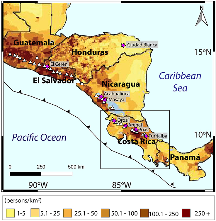
Figure 1. Central America and its population distribution (modified from CIESIN et al., 2011). Volcanoes are identified by white triangles and archeological sites by purple stars.
Framework
Human-Volcano Interactions: Previous Work
Multiple studies on the impact of volcanic eruptions on human activities have been carried out worldwide (Cashman and Giordano, 2008; Grattan and Torrence, 2016; and references therein). In recent interdisciplinary studies, volcanic data provided basic stratigraphic markers and information about the nature and timing of specific volcanic events, archeological data delivered physical evidence of the direct and indirect impacts of volcanic eruptions, and anthropological data offered information on the societal responses to past and recent eruptions (Cashman and Giordano, 2008). In the short-term, these studies record negative impacts on populations due to drastic changes caused by the eruption. Over longer periods of time, positive outcomes arise such as the adjustment to volcanic activity achieved largely through strategies of adaptive land use.
Pre-Hispanic cultures had strong connections with volcanic areas in Mesoamerica. Some cultures believed in deities related to volcanoes, and in some cases love stories between the natives and the volcano gods were told (Alvarado and Soto, 2008) escalating to even more dramatic tales about rituals of live sacrifices to calm the fury of these gods (i.e., as described by Viramonte and Incer-Barquero, 2008; native cultures offered children and maidens in sacrifice to Masaya Volcano during the dry season hoping to obtain rainfall in return).
There are multiple interesting cases highlighting the co-occurrence between volcanoes and pre-Hispanic archeological sites in Central America during the Holocene (Figure 1):
(a) On the foothills of the Orosí stratovolcano in Guanacaste (Costa Rica) petroglyph fields can be found, while the higher slopes and peaks are devoid of archeological artifacts. This is because the volcano would tremble every time someone tried to climb to the summit, which led to the belief that the ascent of humans made the supernatural beings related to the volcano angry (Alvarado, 2008). In this area, volcanic rocks were employed as raw material to make metates, artifacts for rituals, curved dishes, and tripods (Ceruti, 2010).
(b) The Acahualinca footsteps are a series of well-preserved footprints made by a group of 15–16 children, teenagers, women and men found in Managua (Nicaragua). The footprint layer is a tephra (i.e., ash fall deposits) that represents the initial stage of a major and lasting phreatomagmatic eruption of the Masaya Caldera circa 2120 ± 120 years Before Common Era (BCE) (Schmincke et al., 2009, 2010). The individuals walked at a brisk pace toward the Managua Lake shore trying to escape from a powerful eruption occurring 20 km to the south. The excellent preservation of the footprints is due to a series of favorable circumstances including the presence of fresh and wet ash, its quick hardening, and rapid burial by a subsequent eruption (Schmincke et al., 2010).
(c) Located in the remote, impenetrable, and incompletely mapped rainforest of the Mosquitia region in Honduras, the lost city “Ciudad Blanca” was a myth before it was accurately located using Synthetic Aperture Radar (SAR) images in 1998 (Yakam-Simen et al., 1998) and rediscovered using airborne LiDAR scanning in 2009. Thanks to the detailed study of LiDAR images (Fisher et al., 2016), it was determined that this civilization profusely shaped the landscape through engineering before disappearing sometime after the arrival of Spaniards in the sixteenth century (Yakam-Simen et al., 1998). LiDAR technology was also used successfully in Costa Rica for archeological purposes around Arenal Volcano (Sheets and Sever, 1988; Sheets et al., 1991) and to map and model the Costa Rican rock spheres (Ruiz et al., 2014).
(d) The pre-Hispanic village of Cerén, located near San Salvador (El Salvador) was suddenly buried by a thick layer of volcanic ash ~1,420 years ago [600 Common Era (CE); Sheets, 1992; Parnell et al., 2002]. The localized eruption of the Loma Caldera volcano provided the villagers with enough time to flee but buried the village with ash. Part of this finely preserved archeological site was mapped using ground penetrating radar (GPR) before excavation. A subsurface interface radar system (SIR-7) with a single 80 Mhz antenna was used to penetrate the 5 m of volcanic deposits (Conyers, 1995). The rapid burial with airfall deposits allowed the preservation of artifacts and structures, as well as of organic materials such as food stored in vessels, thatched roofs, and plants in gardens giving a very precise idea of the activities, diet, and lifestyle of local inhabitants (McKee, 1999; Sheets, 2003).
Sites of Study
Our study focuses on two case studies of pre-Hispanic settlements located near active Costa Rican volcanoes (Poás and Turrialba). The main objective was to use the geomorphology of these areas to understand why these places were selected to build ancient settlements and look for relationships with modern towns.
In both sites, previous archeological and geological studies were incorporated into this study. The geological and geomorphological information in the Poás region is based on works by Ruiz et al. (2010), Salani and Alvarado (2010), Alvarado (2008) Alvarado et al. (2011), and Ruiz (2012), and the archeological information relies heavily on the works of Hurtado de Mendoza and Castillo (2005), Zúñiga Jiménez (2005), and Alvarado et al. (2011). In the Guayabo region, geomorphological information is based on Obando and Peraldo (2011) and part of the archeological information is based on Fonseca and Hurtado de Mendoza (1984), Acuña (1987), Aguilar (1972), and Alarcón (2012, 2013, 2017).
The study area for the Poás case study is restricted NS between the Von Frantzius cone to the Río Cuarto Maar and EW between the Toro and Sarapiquí Rivers (Figure 2). For the Turrialba case study, we focused on a strip of land located on the southeast flank of Turrialba Volcano between the Guayabo and Lajas River canyons (Figure 2).
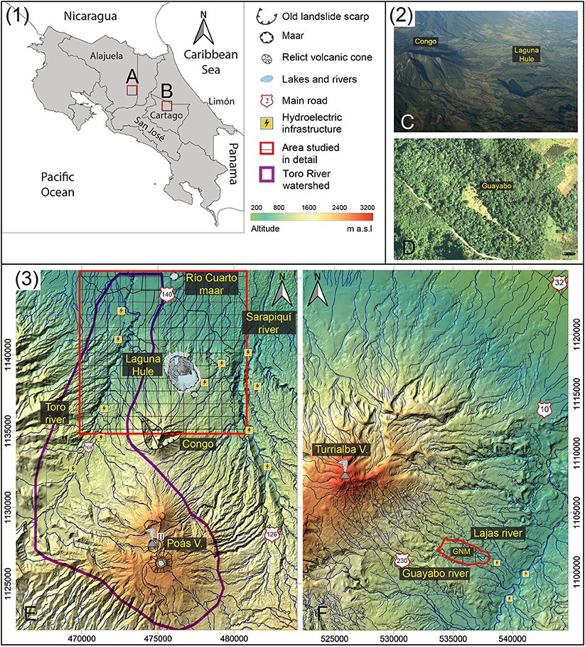
Figure 2. Location of the studied areas: (1) Map of Costa Rica where the location of Poás (A) and Turrialba (B) Volcanoes are highlighted; (2C) aerial photos from northern Poás (2D) and the Guayabo National Monument; (3) DEMs of Poás Volcano based on LiDAR (E), and Turrialba Volcano based on local topographic maps (F). Areas in red are detailed in Figures 3 and 5, respectively. Local coordinates are in CRTM05.
Poás and Turrialba Volcanoes are actively erupting (as of the date of submission of this manuscript). Turrialba started with phreatic activity in 2010, and since 2015, juvenile magma has been involved in the eruptions (Lücke and Calderón, 2016). Meanwhile, the volcanic activity at Poás started in April 2017 with a phreatomagmatic eruption, which led to the closure of the national park (one of the most visited national parks in Central America) and impacting the daily lives of people near the volcano (Ruiz and Suárez, 2017). Thanks to these first hand observations, we are learning about how these eruptions affect lives in the modern tropical CZ, and we are able to speculate on how a similar activity could have impacted pre-Hispanic populations.
Methodology
General Approach
We provide a multidisciplinary approach integrating geological, geomorphological, archeological, and anthropological data from two separate sites, which are later compared spatially and through time. This section presents the theoretical method proposed while the next section highlights the detailed analytical data collection approach employed in this study. The aim of this method is to comprehend the interactions between humans and volcanoes beyond the direct impact of volcanic activity, therefore taking into account not only social and cultural changes caused by volcanic activity as reflected in geological and archeological records, but also the coexistence of pre-Hispanic cultures with volcanoes, and their interaction with volcano-derived aspects of the CZ (e.g., quality of soils, topography, use of geomorphological aspects, etc.).
The proposed methodology focuses on sites selected based on two criteria: (1) sites located next to an active volcano with known past activity, which has been also recently active, and (2) sites with known or reported archeological remains. The sites are assessed considering existing information and/or generating new information based on field observations. General characteristics taken into account include site location, past and present land use, use of geomorphological aspects, and cultural development.
After selecting a site, a compilation of cartographic information and/or satellite images are obtained. Information for this purpose can be divided into two sources. The first is easily accessible, low-cost and open-source information including Google Earth images, topographic information available through the GeoMapApp application, 1:25,000 and 1:50,000 topographic maps and historical aerial images from the National Geographic Institute of Costa Rica (IGN), data available through OpenLayers plugin or QuickMap services in QGIS, GIS data available through the United States Geological Services (USGS) portal, data available through the European Agency (ESA) Earth Online portal, and data from the National Service of Geographic Information of Costa Rica (SNIT). The second is higher-cost, more exclusive and detailed information mainly obtained from surveyes carried out by means of the aerial LiDAR (i.e., applied in the Poás region) and terrestrial LiDAR (i.e., used at Guayabo). Once the geospatial information has been gathered, images are applied to determine land use, which was then checked during the fieldwork. Topographic information is used to generate digital elevation models (DEMs), which are in turn utilized to generate slope maps and hydrological networks, and all of these data combined are used to create geomorphological maps, which were later corroborated in the field. Based on the information gathered, the past and present exploitation of topographical and geomorphological features, land cover, land use, and use of volcanic materials is analyzed. Present impact of volcanic activity ought to be investigated and compared to past activity and their possible impacts.
Where geological or archeological information are lacking, field studies should be carried out in order to determine geological structures and units, relative ages and stratigraphic relationships, as well as archeological information such as cultural period. On specific locations (e.g., at confined archeological sites), other researchers (Garrison, 2016) have been successful in conducting, complementary investigations using geophysical methods such as electrical resistivity and conductivity, electromagnetic (EM) and GPR, which have shown to be effective for archeological purposes.
Detailed Data Collection Approach Employed in This Study
The aerial LiDAR data used for the Poás site was obtained by airplane in April 2009. The data acquisition and processing campaigns were done by AeroDivaSA and STEREOCARTO, respectively. The scanner used was an ALS50-II LEICA system. The resolution of these LiDAR images is three to four points per m2, which is enough to create a DEM with a resolution of 50 cm in the x and y axes, and 15 cm in the z. Ground GPS data were used to make altitude corrections. The obtained topographic data were processed using the commercial software packages SURFER 9.0 and GLOBALMAPPER 13.0. These data were previously used by Alvarado et al. (2011), Ruiz (2012), and Ruiz et al. (2014). High-detail orthoimages in real and false infrared color were used together with the LiDAR data, with the addition of other orthoimages obtained from the SNIT platform for imagery. In the Turrialba region, basic topographic information was obtained from 1:25,000 maps from IGN, and the imagery is from Google Earth and open access Base Maps accessed through QGIS. The same software packages were used to generate the maps and block diagrams.
New terrestrial LiDAR data were obtained in 2013-2014 by the Unit of Management and Evaluation of the National Road Network from LANAMME-UCR for the Guayabo National Monument (GNM) as part of the restoration project supported by the Ministry of Culture and Ministry of Environment. The equipment was a second-generation Leica laser scanner C10, with high capacity internal batteries, allowing its true portability. It has the size of a topographic survey station and weighs less than 20 kg, so it can be put on a tripod. It has a laser emitter/receiver set that is capable of sending 50,000 light beams per second. The final point model generated for the GNM presents more than 2 × 10⁷ points with the objects located < 50 m from the scanner position during the data acquisition. This LiDAR data is used to explore the geometric relationships between the monument and the volcanic edifice itself.
Elevation models were improved using LiDAR data to obtain high resolution DEMs. Past land use and cover were determined or estimated based on historical accounts and archeological surveys. For the Poás region, the discussed settlements were identified by means of archeological information; fieldwork in the region enabled a reinterpretation of characteristics related to the interaction of pre-Hispanic inhabitants with their surroundings, including effects of volcanic activity, possible causes for the location of settlements and use of volcanic materials. Extensive studies previously conducted at the GNM and fieldwork from this study were combined to ascertain the aforementioned characteristics at this second site. Present activity at both volcanoes surveyed and investigated and relevant traits were compared to events registered in geological records. Ancient indigenous land use was compared to planning and development of suburban areas by modern inhabitants in the last few decades. We present the obtained information as block diagrams to facilitate readability.
Results
Poás Volcano Case Study
On the northern flank of the Poás Volcano, archeological studies have revealed that pre-Hispanic cultures living in the area were affected by volcanic activity related to the Hule and Río Cuarto Maars, which were active during the Holocene (Alvarado et al., 2011). In this study, detailed LiDAR images and aerial photos were used to assess current land use and provide an accurate description of the geomorphologic features of volcanic origin present in the area. Compilation of land uses in pre-Hispanic and modern times appear to be closely related to the volcanic activity and the derived soil conditions.
Pre-Hispanic tribes living in the northeastern part of Costa Rica, known as Votos or Guatusos, are known to have inhabited this region at least since nomadic groups of hunters and gatherers appeared during the Paleo-Indian period (13,500–9,000 BCE) and Archaic period, (9,000–4,500 BCE; Alvarado and Soto, 2008). Hunting activities of the Votos tribes were maintained during the Middle Formative Period (4,500–2,200 BCE) and the first phase of Chiefdom (Cacicazgo) integration (2,200–1,200 BCE; (Hurtado de Mendoza and Castillo, 2005)). A comparative analysis of archeological sites near Poás showed the occurrence of a small scale (<5 km) migration from 3,000 to 500 BCE associated with an episode of volcanic activity in Río Cuarto Maar ~3 kyr and minor volcanic activity involving the Hule Maar ~1.7 and 0.67 kyr (Alvarado et al., 2011).
Geomorphological Aspects and Their Relations to Human Presence
The Poás Volcano (Figure 3) along with the Botos and Von Frantzius Cones, the Cerro Congo Cone, Hule and Río Cuarto Maars (described below in order from south to north) are located on the Caribbean watershed of the Central Volcanic Range of Costa Rica, forming part of the Poás Massif. These are aligned along a volcano-tectonic fissure system with a north-south orientation, which corresponds to profound cortical weakness fractures (Ruiz et al., 2010; Salani and Alvarado, 2010; Alvarado et al., 2011), and the north and south flank of the volcano are limited by the San Miguel and Alajuela tectonic thrusts respectively (Ruiz et al., 2010). Volcanic products from these centers provided fertile soils for agriculture, grazing and raw materials for tools and weapons. The precipitation regime is typical for the Caribbean with year-long rainfall [mean annual precipitation (MAP) is 3,200 mm/yr] and a relative decrease of rainfall in the months of February through April (Solano and Villalobos, 2001). Holdridge Life Zones (Holdridge, 1967) in the Poás area include “Wet Forests” (altitudes around 1,000 m a.s.l, temperatures from 18 to 24°C, MAP around 3,000 mm/yr, potential evapotranspiration ratio from 0.25 to 0.50 for a perhumid environment, and evergreen forests with epiphytes) and “Rain Forests” (altitudes around 1,500 ma.s.l, temperatures from 18 to 24°C, MAP around 4,000 mm/yr, potential evapotranspiration ratio from 0.125 to 0.250 for a super humid environment, and evergreen forests with epiphytes). These high humidity conditions have a direct impact on the rock weathering and soil production, which are linked to the general geomorphology and drainage systems in the Poás Volcano massif.
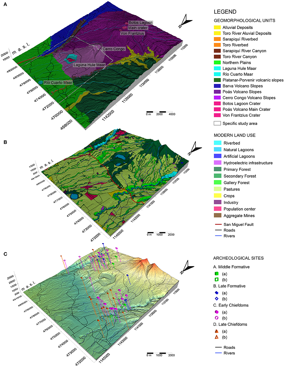
Figure 3. (A) Geomorphological map of the study area north of the Poás Volcano main crater. These block diagrams were created based on a DEM model of the area from the available aerial LiDAR data; (B) Modern land use distribution of the focus area (highlighted in white in A). Note how the San Miguel Fault escarpment (SMFE) physically subdivides the area in two parts (north and south); (C) Location of archeological sites where artifacts have been recovered. Sites are divided into Middle Formative (4,500–3,000 BCE), Late Formative (3,000–2,200 BCE), Early Chiefdoms (2,200–1,200 BCE) and Late Chiefdoms (1,200–500 BCE); and ranked based on the quality of the archeological remains recovered: (a) higher, (b) lower (modified from Alvarado et al., 2011).
Approximately 2 km north of the main crater lies the Von Frantzius Cone, with an elevation of 2,630 m.a.s.l., moderately steep slopes (20–37°) and erosive indentations toward the southwest. This cone and the Cerro Congo Cone further to the north are within the limits of the Poás Volcano National Park, designation guaranteeing the conservation of primary rainforest in this region. It is probable that the last eruption of the Von Frantzius Cone occurred 10 kyr ago (Ruiz et al., 2010) burned down most of the rainforest. In spite of this, the primary forest in this region is dense evergreen and rich in epiphytes (Holdridge, 1967) thanks to the rapid regeneration capacity of rainforests (Chazdon, 2008). The lowlands between the Von Frantzius Cone and the Cerro Congo Cone are moderately dissected by tributaries of the Toro and Sarapiquí Rivers to the west and east respectively. It is probable that no human settlements have ever been emplaced in these lowlands due to the steep slopes, thick forest and hostile climate.
Cerro Congo Cone, or formerly Cerro Cariblanco, is located ~6 km north of Poás Volcano. It has a maximum height of 2,014 m a.s.l., rises 1,300 m above the northern plains and has an area of 25 km2 and a volume of ~3 km3 (Alvarado, 2008). It is a possibly extinct stratovolcano with a last recorded eruptive activity ~11 kyr ago (Alvarado, 2008). The cone is better developed on the northern slopes due to its interaction with the Von Frantzius Cone to the south. The summit of the cone is a poorly preserved open crater with two erosive canyons with moderate to steep slopes (40–60°) toward the NNW and NNE, which probably formed after its last eruption. The inactivity of the Cerro Congo Cone, since ~11 kyr ago, is confirmed by its demolished morphology and lack of a well-defined crater (Alvarado, 2008). Most likely, the first tribes to inhabit the region experienced the volcanic activity of these two cones. Correlations established between patterns of archeological settlements and activity of volcanic centers suggest that colonization of areas near the volcanic centers (Figure 3C) started during periods of quiescence of volcanic activity (i.e., during the last 5,000 BCP) and migration away from these centers coincided with phases of awakening or intense activity (~3 kyr in Río Cuarto Maar and ~1.7 and 0.67 kyr in the Hule Maar) (Alvarado et al., 2011). Reasons for the observed migrations other than the volcanic hazard include the negative impact of volcanic deposits on soil fertility for relatively long periods (approximately a decade), which would motivate a migration toward more favorable environments.
The Hule depression, located between Cerro Congo Cone and the San Miguel Fault Escarpment (SMFE) to the north, is occupied by three lakes (740 m a.s.l): Hule (0.547 km2, 26.5 m deep), Congo (0.149 km2, 14.6 m deep), and an unnamed small lake (0.006 km2, 4 m deep) (Horn and Haberyan, 1993; Salani and Alvarado, 2010). The use of LiDAR images by Alvarado et al. (2011) revealed two intra-maar pyroclastic cones, one growing over the other, which are younger than the Hule Maar and with probable ages between 1,700 and 670 BCE (Horn, 2001; Alvarado et al., 2011). To the SSE of the Laguna Hule, a 25–50 m deep and 400 m wide explosion crater named “Pata de Gallo” can be found. This crater was emplaced after the Hule Maar ~2.8 kyr ago (Salani and Alvarado, 2010). The Hule depression with its three lakes and the Pata de Gallo Crater form what is known as the Bosque Alegre complex. Because this complex is a Wildlife Refuge, most of the primary rainforest surrounding the crater remained untouched after the last major eruptive phase of the Hule Crater ~ 6.2 kyr ago (Alvarado et al., 2011). Slopes to the east and west are low (<15°) and consequently most of the land surrounding the Wildlife Refuge is dedicated to farming and pastures. The 15 km long SMFE is located between the Bosque Alegre Complex and the Río Cuarto Maar (Montero, 2001) and separates the foothills of the Poás Massif and the northern Caribbean plains. It has been described as a thrust fault with an orientation N70°W dipping to the S-SW (Borgia et al., 1990; Montero et al., 2010). The most prominent morphological expression of this fault is a relatively rectilinear escarpment of 100–300 m in height (Alvarado et al., 1988), deep canyons, and changes in the river patterns in the Sarapiquí and Toro Rivers (Montero et al., 2010). Borgia et al. (1990) have interpreted this escarpment as the fore-limb of an asymmetric anticline associated with a thrust fault. This fault is considered potentially active by Montero et al. (2010), who assign a probable age of middle Pleistocene (≤300 kyr) and associated to a compressive reverse and dextral-transcurrent tectonic system.
The Toro River and its watershed lie ~5 km to the west of the Bosque Alegre Complex. On the other side, the Sarapiquí River and its watershed are located 3.5 km east of the complex. Both the Toro and Sarapiquí Rivers show a change in the drainage pattern from near rectilinear to meandering after crossing the SMFE. In fact, before this change, both riverbeds are encased in narrow and deep canyons with sections between 20 and 400 m wide, falls of up to 250 m, and walls with slopes of 45° or more. Most of the tributary rivers present knickpoints at the junction between the main rivers: these knickpoints can be highlighted by cascades or waterfalls (Dávila and McDonald, 2009). In both the Toro and the Sarapiquí watersheds, landslides are common and numerous. These are triggered mostly by rainfall and/or seismic events and are associated with humidity levels, land use, slope, soil cover, or bedrock conditions (Ruiz, 2012). Many hydroelectric dams and associated electric plants, which take advantage of the natural water force and slope gradient, can be found near these two rivers. Almost half of the 49 archeological sites (Alvarado et al., 2011) studied in the area (Figure 3C) are situated in lowland between the foot of the Cerro Congo Cone, the Bosque Alegre Complex, the SMFE and the Sarapiquí River canyon. Most of them were situated south of the SMFE near the intersection between the Toro River canyon and the SMFE. This area offers a great deal of natural advantages including protection from the south thanks to the Poás Massif and from both east and west due to the Sarapiquí and Toro River canyons respectively. This means that pre-Hispanic inhabitants only had to guard themselves from attacks coming from the north. Also, the altitude difference between the south and north of the SMFE offers a strategic location for watchpoints. The Sarapiquí River watershed is of great importance for Costa Rica because of its water resources, which are widely used for electric energy generation, water consumption, fishing, waterways and eco touristic activities. Nonetheless the watershed has problems due to the deterioration of natural resources caused by deforestation, forest fragmentation, land use change, and unsuitable use (Sánchez et al., 2004).
Río Cuarto is a nearly circular maar (700–850 m across) with a surface area of 0.33 km2; it is located 361 m a.s.l. and ~4 km north of the SMFE. There are no radiocarbon ages dating the formation of Río Cuarto Maar, but archeological data suggests that it erupted between 3 and 4 kyr ago (Alvarado et al., 2011). The lake has a maximum depth of 66 m making it the deepest natural lake in Costa Rica, and it is known for its periodic water overturn causing massive fish death episodes (Horn and Haberyan, 1993). During the Middle and Late Formative times (4,000–2,200 BCE) settlements were common close to Hule, while Río Cuarto was generally avoided, which is consistent with the hypothesis of the Río Cuarto Maar being volcanically active ~3–4 kyr (Alvarado et al., 2011). Afterwards, it is probable that Río Cuarto has become dormant since colonization had developed in this area. Settlements near Hule continued and increased during the Early Chiefdoms phase (2,200–1,200 BCE). Areas westward of both centers, probably due to the fall of hardened tephra in this direction affecting soil fertility, were less colonized. During the Late Chiefdoms phase (1,200–500 BCE), the number of sites near Hule drastically decreased probably in response to mild volcanic activity at ~1.7 and 0.67 kyr (Alvarado et al., 2011).
Land Use
The soil in this region is mostly regolith derived from lava weathering and volcanic ashes. It is dark, rich in organic material and has a good agricultural potential (Ecoplan Ltd, 2003 and this study). Since the establishment of nomadic groups of hunters and gatherers during the Paleo-Indian period (13,500–9,000 BCE) and Archaic period, (9,000–4,500 BCE) (Alvarado and Soto, 2008) land use has changed a great deal in the northern Poás region. Although not much is known about the diet of the Votos Tribes, it is possible to speculate that hunting and gathering activities were maintained in the Middle Formative (4,500–2,200 BCE) and that the first phase of Chiefdom integration (2,200–1,200 BCE) (Alvarado and Soto, 2008) had little impact on the landscape and land use except for the establishment of walking trails connecting the campsites. Study of archeological artifacts (Hurtado de Mendoza and Castillo, 2005; Zúñiga Jiménez, 2005) shows that most tools and weapons, which were used for hunting and processing animal carcasses, were made of porphyritic andesitic lavas associated to the surrounding volcanic centers, and only one knife made of aphyric lavas, which are less common in the area, was found. Most of the study sites do not seem to be sedentary housing sites linked to agriculture, but rather locations of occasional repeated use and short duration, which make them most similar to modern campsites and hunting grounds (Hurtado de Mendoza, personal communication).
Archeological research in the Hule-Río Cuarto area performed since the 1960s has revealed 49 single sites (Alvarado et al., 2011) presenting the following cultural transitions: (a) colonization by hunters during the Archaic Period; (b) transition to an agricultural economy; (c) apparent cultural recession prior the contact with the European culture (Hurtado de Mendoza and Castillo, 2005); and (d) development of plantains, bananas, corn and cocoa crops (Von Frantzius, 1862; Solórzano, 1999) after interaction with European explorers. Because these are autochthonous products, it seems reasonable to suggest that these products were probably also harvested before contact with Europeans implying that during and after the Middle Formative some land use change would have occurred, turning woodlands or pastures into small agricultural fields. Changes of land use from woodlands and pastures into farms started after colonization in the 1800s and changed gradually up until the twentieth century becoming much more intensive over time. In addition to traditional crops of corn, rice and beans, crops harvested during the twentieth century included rubber, abacá, cinchona bark, and balsa (Picado, 2012). The cinchona bark was of particular importance for the procurement of antimalarial quinine during the Second World War. The submission of Java to the Japanese forced the USA to establish programs of cinchona procurement in Latin American countries where cinchona trees are native (Hodge, 1948). Although there are no specific accounts of sites where cinchona was produced during WWII, the eastern flank of the Poás volcano is noted for the harvest of these plants, giving the name to the town of Cinchona, which became well known due to the damage caused by the 2009 6.2 Mw Cinchona earthquake and the associated landslides, which destroyed 90% of the town and killed 29 people (Rojas et al., 2009).
Regarding modern land use, a classification established by Ecoplan Ltd. (2003) in the Río Cuarto district (now Río Cuarto canton) yields the following percentages: 18.6% woods, 34.1% crops, 47.5% pastures, and 0.3% residential use. Based on our findings, the most important crops in the district are tapioca and pineapple (in the northern part) and corn, ñampí, and other crops can that be found in smaller parcels. Most of the pastures are intended for cattle grazing, while the woods are limited to riparian forest zone and protected areas. The two towns of greater importance in this region are Río Cuarto and Santa Rita. Overall the land use in the area is adequate although a greater assistance to promote correct land management and conservation practices among farmers is needed. Intensive farming and use of pesticides in some areas, especially in pineapple cultures where farmers use ~20 kg/hectare/cycle of pesticides like Furadan (one of the most toxic carbamate pesticides, which is a nerve poison) have a negative impact. Additionally, as compared to pre-Hispanic times, only a fraction of the original woodlands remains and it is now evident that intensive farming has had a negative impact on soil quality and long term sustainability.
What Have We Learned from the Present Day Activity of Poás Volcano?
Based on our recent observations, because of the preferential wind direction (NE-SW), when the volcanic activity is located in the main crater of Poás Volcano, the northern flank of the volcano is not directly affected by the ash or volcanic gases. Rarely, when the wind blows northward, the volcanic gases mix with the great amount of moisture that exists in the Caribbean side of Poás Volcano and generate acid rain. Precipitation of this acid rain can affect crops and water resources to a variable degree. Similar events may have taken place in pre-Hispanic times. However, it is not common to have a northern wind direction for long periods of time, which means that the impact is limited. The crops and activities of the pre-Hispanic people that lived on the northern flank of the Poás Volcano were probably not affected by ashfall when the volcano had activity similar to the current one.
However, based on the activity recorded during the April 2017 eruptions, lahars have the potential to impact human activities in the CZ along the river canyons of the northern side of Poás. Several lahars were documented in the Toro River Basin (Figure 4) due to recent volcanic activity. These events disrupt modern societies, caused the hydroelectric power plants to stop producing energy and all the tourist activities in the rivers had to be canceled. Additionally, important seismic events have the potential to trigger landslides (Newmark, 1965; Jibson and Keffer, 1993; Ingles et al., 2006), which mixed with heavy rainfall can become lahars. Near the Poás Massif six historic seismic events with magnitudes over 5 have occurred between 1770 and 2010, including the Cinchona Earthquake in 2009 (Montero et al., 2010). All of these events triggered lahars, thus indigenous cultures probably experienced earthquake-induced lahars during which the activities carried out in the canyons of the Sarapiquí and Toro Rivers (e.g., Figure 4E) such as fishing, bathing and water extraction were disrupted.
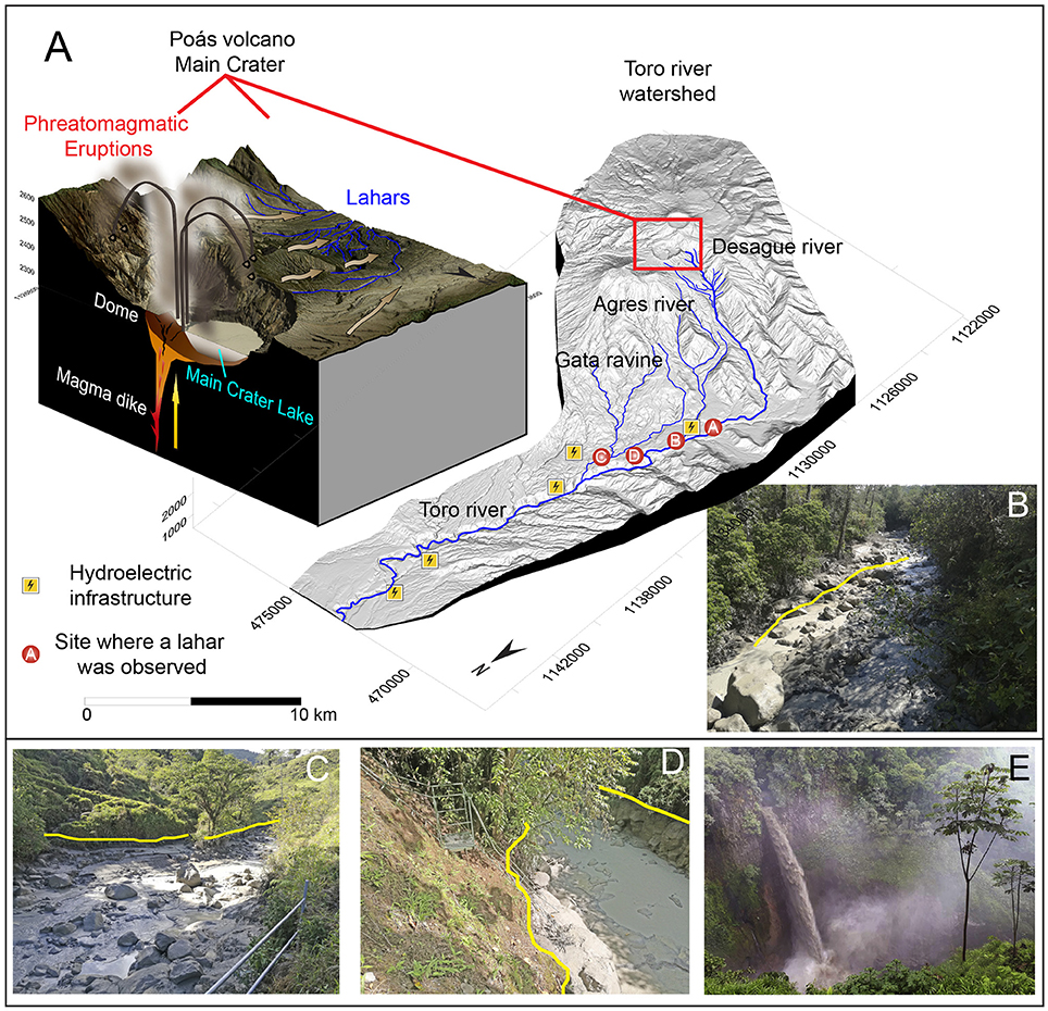
Figure 4. On April 2017, a phreatomagmatic eruption on the Main Crater of Poás Volcano expelled water, sediments and juvenile material into the air. (A) Schematic view of the eruption with a DEM of the Toro River watershed with the location of images where lahars arrived. The yellow lines on the pictures mark the upper limit of the lahar in the river channels (mud line): (B) Desagüe River; (C) Agrio River; (D) Gata Creek; (E) Lahar falling into the Toro River. Water of this waterfall is normally clear and is a tourist attraction.
Furthermore, both the Hule and Río Cuarto Maars experience periodic water overturns, which cause changes in water color and fish killing (Alvarado et al., 2011). These events are not large enough to kill people unless they stay at the border of the lake or swim in it at the time of the event, but they can have an impact on local wildlife. At present, the Bosque Alegre Complex boasts a number of bird and animal species due to its protected area statute. Pre-Hispanic inhabitants may have been taken by surprise by these types of events, which affected the species they hunted.
Turrialba Volcano and the Guayabo National Monument Case Study
The ruins of an ancient settlement that today is known as the Guayabo National Monument (GNM, Figure 1) are located on the southeast flank of the Turrialba Volcano, the easternmost active volcano of the Costa Rican Central Volcanic Range. This archeological site is within the Cartago province, just 85 km east from the capital of Costa Rica, San José. In 2009, the American Society of Civil Engineers (ASCE) declared this site as World Heritage of Engineering, recognition that was obtained due to its beauty and its aqueduct fine design, which are still working properly thousands of years after they were built. This declaration encouraged its preservation and maintenance in the last decade.
In 1502 Christopher Columbus, as part of his last trip to America, arrived to the Caribbean coast of Costa Rica. He and his crew interacted with the natives from the island of Cariari, which today is called “Uvita Island,” located just in front of the city of Limón. The historical accounts tells that by the time of Columbus arrival to this part of Central America, the pre-Hispanic settlement of Guayabo was already abandoned and many years had passed since its cultural peak (Aguilar, 1972). Based on a variety of radiocarbon dates from the Guayabo site we know that the construction had been developed ~900 and 1,100 CE (Alarcón, 2013). Based on the location of the samples analyzed and our understanding of the construction processes (i.e., bases, terraces, and stone pathways) the peak of the Guayabo constructive development has been calculated between 987 and 1,032 CE (Alarcón, 2017) based on data indicating the age of the construction.
As part of the restoration and maintenance programs of the GNM, the National Laboratory of Materials and Structural Models from the University of Costa Rica (LANAMME-UCR) took part in the generation of a three dimensional model of the site before and after the restoration of the main square and central stone pathway of the archeological site. These high resolution 3D models were made in 2011 and 2014 using a terrestrial LiDAR scanner (the raw data is available upon request for research projects). A small video of these data can be found on the LANAMME-UCR YouTube channel (LanammeUCR, 2014). The three dimensional rendering of the constructions allows the recognition of pre-dominant features such as the stairs and main pathway alignment of the construction (NW-SE), graves, aqueducts, a cluster of circular foundations where houses were built and surrounding walls. Due to the speed of the video and the constant changes in light and shadows, we encourage researchers to request the raw data to fully appreciate it.
Employing historical aerial photos, Base Imagery Map (ArcGis) and historical accounts we developed a compilation of different land uses in the area surrounding the GNM over time from pre-Hispanic times until today (Table 1). This compilation allowed us to compare land uses over time revealing similarities and differences, and providing key information for the planning of future development in similar areas. In order to understand the benefits and difficulties that the ancient and current inhabitants of Guayabo faced by living on the flank of an active volcano, a geomorphological analysis of the area is provided (Figure 5). This map, overlayed over a DEM, shows the data from Obando and Peraldo (2011) and our own discoveries and interpretations of the external geodynamic processes that are currently impacting this area.
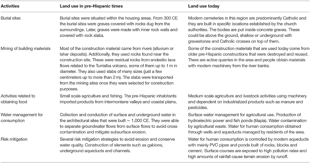
Table 1. Comparison of past and modern land use in GNM and its surrounding area, based on our observations.
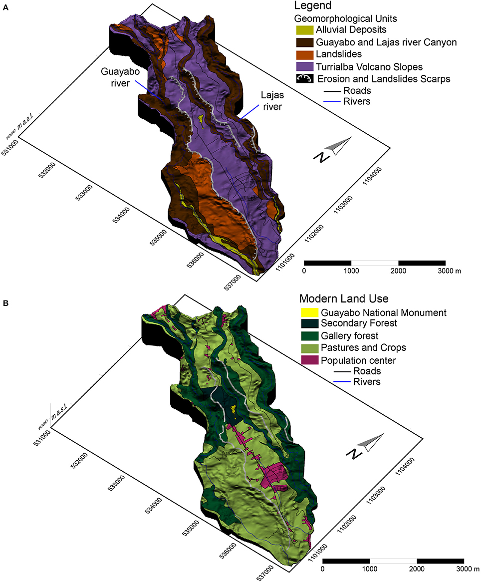
Figure 5. (A) Geomorphological context in the area of the Guayabo National Monument, based on Obando and Peraldo, 2011 and our observations; (B) Modern land use distribution around the GNM.
The GNM is one the most architectonically complex pre-Hispanic centers documented in Costa Rica. Archeologists have been able to identify 44 foundations, 3 squares, 4 ponds built to contain water, 3 aqueducts, 2 longitudinal roadways, a central square interconnected by a stone paved pathway, stairs and bridge systems (Fonseca and Hurtado de Mendoza, 1984). The use of geomorphology and understanding of the geodynamic processes present in this area may have played a key role in the success of building these architectural features. The original topography of the area where the GNM was developed was uneven and ground adjustments were performed during the pre-Hispanic time to build the monument. Hydrological knowledge had to be applied to be able to conduct water with high precision and allow the development of the site itself. Terraces were built on the surrounding hillsides to integrate and articulate the architectural design with the environment (Obando and Peraldo, 2011). Based on our observations, the archeological site is located in a landslide/fluvial erosion prone area. The terraces and water channels are thought to have been planned in order to reduce and mitigate the risk factors related to fluvial erosion and landslides (Baltodano et al., 2014). In fact, at the GNM, there is evidence of urban planning and constructions standardization in the homologation of the building supports (from 1 to 3 m height and up to 30 m in diameter), the position of the terraces, and the cobbled areas located around main buildings. The water flow management is evident due to the presence of hydraulic infrastructures inside the GNM with ponds and open and closed channels.
Recently, stability problems have been detected on the site. These problems are related directly to the uncontrolled surface and groundwater circulation, which have damaged some of the structures over the years. However, based on Obando and Peraldo (2011) and what we have seen in the field, so far the mass movements at the site have been only superficial and limited between the ground and the bedrock (no more than 5–6 m deep). Although there are evidences of important mass displacement in the surrounding areas, they are not directly affecting the GNM.
Unlike the case study of the pre-Hispanic people of the Poás volcano, Guayabo was developed based on a structured decision-making central organization controlling all aspects of the settlement development and beyond. A network of controlled roads, which connected the different settlements, existed. The road network related to the GNM extends for almost 15 km as documented thus far and integrates settlements in a 4 km radius (Acuña, 1987; Alarcón, 2017). The access to the pre-Hispanic settlement appears to be closely associated to the geologic setting of the area. For example, the main access road to the GNM (Calzada Caragra) is a walkway orientated toward the Turrialba Volcano summit (Fonseca and Hurtado de Mendoza, 1984). This stony road connects the southeast access of the GNM to the architectural core (biggest foundation) and extends further to the southeast. Its extension has been measured to 5.4 km and goes from the GNM to Nájera archeological site, where it changes its direction to the southwest and continues for 4.3 km to La Zoila archeological site. Overall its width is between 4 and 5 m (Vázquez, 2002). To the northeast, the walkway Palomo extends for more than 4 km to the archeological site Palomo-1 with a width of 2.5–3 m (Acuña, 1987).
Morphological and Physiographic Features of the Guayabo Area
Because of its location, the GNM is exposed to large volumes of moisture, which enter the continent coming from the Caribbean Sea and generate high precipitation rates. Based on the local meteorological data collected between 1985 and 2011, the MAP is 3,800 mm/yr and the mean temperature is 22°C. Employing data from vegetation, fauna, climate, physiography, geological formation and soil, the GNM Holdridge Life Zone was classified as a tropical region that includes two types of forest: (a) Very Humid Forest, and (b) Pluvial Forest. These show altitudinal floors called Premontane and Lower Montane, that have very similar species association (Holdridge, 1967). Over time, the original local Holdridge Life Zones features have been modified by human activities such as deforestation, agriculture (coffee and sugar), and livestock activities, especially after the end of the nineteenth century (Aguilar, 1972). Some of these changes in the flora and the fauna are in the process of regeneration in recently protected areas of the Central Volcanic Range Conservation Area, such as the GNM and the Turrialba Volcano National Park. During the time of construction of the GNM, ~1,000 CE, the environment in Central America was warm with moderate rainfall. These climatic conditions favored the intense weathering of the Turrialba volcanic materials and agents such as gravity and water accelerated the erosional processes. Because the paleo-CZ in this region included unstable terrains leading to landslides occurring both in dry and saturated conditions, it was key to manage water flow and mitigate risk factors during construction by leveling the ground with retaining walls that we call “pre-gabions” due to the fact they are similar to modern gabions (Figure 6).
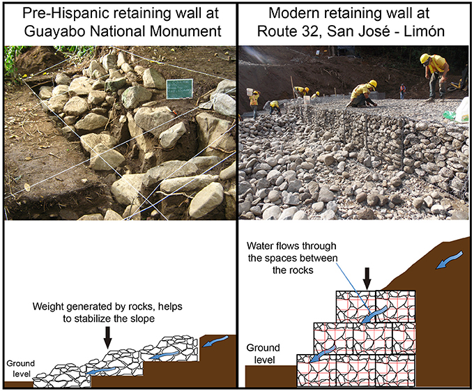
Figure 6. Comparison between pre-Hispanic (“pre-gabions”) and modern gabions. During pre-Hispanic times the retaining walls were built with blocks selected from the river areas. These prevented soil erosion by optimizing surface water flow. Similarly to modern retaining walls, they helped to maintain slope stability by letting water pass while adding weight to the ground on the foot of the hills.
The summit of the Turrialba Volcano has three craters, which are aligned northeast to southwest; the southernmost one has been active since 2010. The volcano is composed by a sequence of lavas (from basalts to dacites) and pyroclastics. The intense weathering of these volcanic materials, the high slopes and the high amounts of rain make this area very susceptible to landslides. It is common to find creep guilles, sharp scarps and mega landslides as defined by Tuan et al. (2013) in the Reventazón River slopes (Obando and Peraldo, 2011). The mass movement processes can be triggered by excess of rain and/or due to earthquakes (Linkimer and Soto, 2016). If the materials from these landslides reach the riverbeds, they can generate lahars, which are then deposited on the low altitude areas and on the river valley walls. The topography of these deposits can be unstable as well, and can generate earthflows in the lower areas. Lahar deposits are made of a sandy clayey matrix with boulders and smaller clasts that tend to erode easily. The lateritic soils forming from these deposits are dominated by forest or pastures since they are not good for agriculture purposes (Dondoli and Torres, 1954).
Thanks to historical accounts and geological mapping, we know that the pyroclastic deposits related to the activity of Turrialba Volcano between 1864 and 1866 went mainly toward its western slopes, severely affecting them, while ashfall reached the Central Valley and went as far as the Pacific coast of Costa Rica (Reagan et al., 2006; Soto and Mora, 2013). Therefore, the area of the GNM was not directly affected by this volcanic activity, even if located less than 20 km from the vent. This pattern has not changed. Based on our recent observations and volcanological reports (Alvarado et al., 2016) focused on the eruptive cycle of Turrialba Volcano since 2010, only a few minor eruptions produced pyroclastic currents into the crater area and there are no reports of ash falls on the eastern slopes or within the GNM area. Additionally, no ash deposits related to the Turrialba volcano and associated to pre-Hispanic sites have been found in the eastern side of the volcanic edifice nor in direction of the Turrialba Valley (Alarcón, 2013; this study). Lava blocks of basalts and andesites have been found at the base of some of the constructions; however, these are related to lahar deposits.
Guayabo: Land of Landslides and River Valleys
The drainage system of the study area shows two main river valleys (the Guayabo and the Lajas Rivers) running from NW to SE of the study area. These erosional features correspond to V-shaped valleys in the upper and middle altitude areas (1,410–935 m a.s.l.), where they are almost completely confined and could be considered canyons typical of a torrential regime. On the contrary, at lower altitudes (935–685 m a.s.l.), these valleys have a less confined wider morphology with some sinuosity and could be considered as true alluvial valleys due to the altitude and the morphology (Brierley and Hickin, 1991). Overall, they extend for over 9 km within narrow corridors (50 m in some areas) that resulted from deep fluvial erosion of lavas and tephras. The walls of these river valleys are mostly covered by gallery forest except for those zones in which landslides have removed it.
In the study region, areas with gentle slopes (<8°) have an efficient drainage system. These are low-energy fluvial zones with meandering river styles (Bridge, 2009) where deposition is common, and the upper layer of the soil observed is dark due to the rich content of organic material. These soil have medium grain-sized texture with almost no preserved content of their parent rock. They are fertile, crumbly and good for agricultural activities. The areas with medium slopes (8–16°) are well drained but with deeper grooves. The soil present here is very similar to the one observed in the areas with gentler slopes; however, the erosion processes are more common and ash remnants can be found in some of the layers. These deposits are less fertile than the ones located on lower lands, but still good enough to be used for agriculture. The areas with high slopes (16–35°) present a very abrupt relief and very deep drainage systems. Erosion processes are common in these areas and can sometimes generate threats like landslides. The observed residual soil is reddish and can be found on road cuts and drainage channels related to livestock activities since it is good for crops (Vásquez, 1991). Canyons present steep slopes (>35°), in some cases almost vertical with maximum altitude changes of 60 m from the scarps to the river bed. They are highly susceptible to erosion and landslides, while the lower parts of the valleys are associated with colluvial and lahar deposits (Obando and Peraldo, 2011). Most of the observed mass wasting forms are rotational and are located on the Guayabo river walls not far from the GNM.
Based on our observations, most of the materials used to build the GNM came from the banks of the Guayabo River. The distance from the river banks to the GNM is in average less than 2 km, which is a reasonable distance for humans to carry rocks that are not larger than 50 cm. Local inhabitants recognized the potential of these volcanic materials as construction materials and used them to build roads as well as the basement of their houses and buildings. Nowadays, these rocks are not employed for any type of construction within the study area. However, in the lower lands outside the study area and other parts of the country, volcanic rocks from the local riverbeds are commonly extracted to be used as aggregates for roads basements and concrete.
Around the year 1,000 CE, structures designed to contain the ground in areas with high slopes were built at the GNM. These structures worked similarly to today's gabions: they helped to maintain slope stability by letting water pass while adding weight to the ground on the foot of the slope (Figure 6). The stabilization of the ground allowed to create even surfaces near the architectural core to built habitations. Furthermore, these areas were used for agricultural purposes, especially near the Guayabo and Lajitas River Valleys.
Land Use and Infrastructures
The construction of the GNM architectural nucleus was a planned process that integrated the monument with surrounding areas, which were established and occupied during that period (Fonseca, 1981; Alarcón, 2017). The various constructions were designed in stylistic uniformity. Fonseca (1983) highlighted how structures such as terraces and basements were “connected by a series of paved sidewalks and stairways” and “the way the different features are separated, grouped together and connected […] makes it possible to establish social units.” This improved design and use of all spaces resulted into a major centralization. Thus, modifications and adaptations of land use, as well as the centralization of settlements, were carried out in a planned way ~1,000 CE (Fonseca, 1979, 1983).
According to estimates from the archeological investigations previously carried out at regional level by Fonseca and Hurtado de Mendoza (1984), the settlements in the study area date back to 1,500 BCE. Hamlets and funerary areas were permanently established from the time interval corresponding to the El Bosque Cultural Phase, between 300 BCE and 300 CE, and their use continued between 300 and 900 CE during La Selva and up to 1,550 CE with the La Cabaña phase. During 200 years, ~900 and 1,100 CE, the rate of constructions and conversion of spaces thought to accommodate human activities was sustained. These activities were carried out in an organized way, taking into account geologic and climatic conditions, integrating socio-political adhesion factors as well as a series of cultural adjustments in order to effectively take advantage of the natural resources at their disposal. Additionally, it is stated that “The good functioning and efficiency of their systems is evidence that each trait was placed with a concrete and interrelated objective with its environment” (Dubón et al., 1984). A political union centralized the power around the eleventh century. The roads that integrated the GNM with other settlements show a way of planning the transit, which conditioned the control of areas beyond the center of population. Similar political control on roads has been studied in the Sierra Nevada region of Colombia (Giraldo, 2010). The work of road infrastructure, hydraulics, and retaining walls to avoid erosion of the slopes in the canyons of the Guayabo and Lajas Rivers is evident. The retaining walls, like gabions (Figure 6), were built with the same constructive techniques used for the basement walls and platforms. Subangular blocks with relatively flat facets were selected from the river areas where the volcanic materials, mostly lahars and alluviums, were exposed as well as slabs extracted from outcrops in the river canyons walls. The rocks, between 20 cm and 1 m in diameter, were placed without mortar or cementitious so as to fit the shape of the gap or, and if necessary, were partially modified to give regularity to one of the facets (Alarcón, 2012). These pre-cautionary actions prevented soil erosion and allowed to optimize surface water flow and facilitate its conduction toward paved areas, ponds, reservoirs and canals, which were built with retaining walls and floors to avoid gradual erosion. These channels also had steps in order to slow down the water velocity and diminish the impact on riverbeds (Baltodano et al., 2014). Our studies showed that the perimeter-paved areas of the structures were designed with an adequate slope to allow the rapid flow of rainwater to watercourses and water wells as a way to optimize the collection of water. The total archeological area covers about ~15–20 hectares, but only a small part of which has been excavated and mapped. In Figure 7, we present and compare a topographic map of the GNM made in 1979 based on a conventional topographic survey with our map made with LiDAR technology obtained in 2014. The parametric data of each of the mapped structures with LiDAR can be easily obtained as shown in Figure 7.
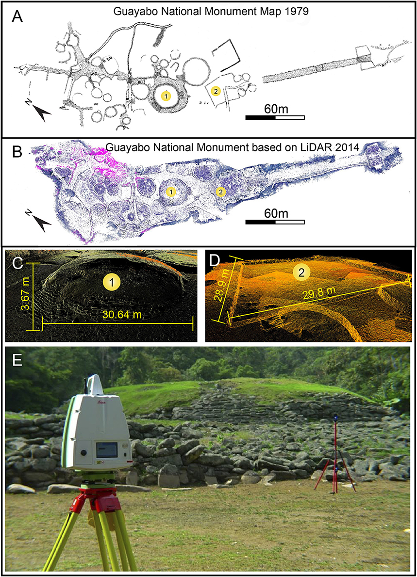
Figure 7. (A) Guayabo map from Fonseca (1979) based on conventional topography survey; (B) Guayabo map based on LiDAR data collected in 2014 by LANAMME-UCR; (C) Main circular basement of Guayabo LiDAR image; (D) Main square LiDAR image; (E) In the foreground the Leica LiDAR Scanner C10 used to obtain the data above. The flat area in the middle corresponds to the main square and in the background of the picture, the main basement is visible.
The construction of the GNM hydraulic system was due to the local environmental conditions as part of the planning of the settlement as a structural unit. The administration and the use of water courses was considered together with the location of public spaces with different purposes such as official access, passage areas, terraces, platforms, and basements (Alarcón, 2017). The planning of an infrastructure built to conduct, distribute, store, and evacuate water made it possible to prevent erosion along the natural water courses and permitted the establishment of water reservoirs in strategic parts of the villages; as it can be observed in archeological sites such as GNM (Alarcón, 2017). The structures destined for the hydraulic control have been classified according to functionality based on the identification of water flows connectivity: two for groundwater flow and one for the control of superficial rainwater runoff (Fonseca and Hurtado de Mendoza, 1984).
After the fifteenth century, the mountainous area of the Central Caribbean slope, including the Turrialba Valley, experienced a decline in the occupation and the construction boom halted. The acute intervention since pre-Hispanic times as well as the relative young age of materials in this area has contributed to the fragility of the ecosystems, especially regarding plant coverage and unplanned digging of water courses. During the sixteenth century, the political organization of the eastern end of the Central Valley had the Guarco Chiefdom controlling the main city with the other settlements hierarchized according to the degree of kinship with the cacique (chief). In this way they unified the political power and ensured territorial control (Fonseca and Ibarra, 1987; Ibarra, 1990), in contrast to the northern Poás area, where the Votos or Guatusos Tribes still lacked a unified socio-political order at that time.
Recent modifications of the land (see Table 1 for land use comparison), have been made to prepare the soil for agriculture. This activity has altered and partially destroyed architectural pre-Hispanic sites and other pre-Hispanic cultural features, such as cemeteries, living spaces, and growing areas (Alarcón, 2017). Additionally, archeological materials have been exposed during plowing operations and the excavation of drainage channels. The fragility of the area was intensified due to the land bound to new farmers, displaced by the activity of Irazú Volcano, in the early 1960s. At present, the physiognomy of the terrain has been altered by the use of heavy machinery to plow and level the ground and other anthropic factors such as the construction of drainage channels on farms and in areas with a higher degree of urbanization, construction of water reservoirs of different sizes for tilapia production and livestock together with the construction of infrastructures such as buildings, roads, warehouses, and greenhouses. These recent anthropic interventions have led to the destruction of a large number of archeological sites and accelerated erosion on the steepest slopes in the area due to deforestation.
Human occupation in this area over time has been directly related to the efficiency in social decision-making. The ability to change the environment to accommodate cultural needs with infrastructures such as aqueducts for transport and storage of water allowed the improvement of the living conditions. These constructions resulted in what archeologists describe as monumental architectural expressions. At present, the risk factors to be taken into account to optimize the anthropic occupation include high rates of precipitation over a short period of time, deforestation, which has led to greater volumes of materials mobilized by landslides, and rainwater runoff that affect modern human settlements and communication routes.
Discussion and Conclusions
In this study, the integration of an interdisciplinary approach has allowed a greater understanding of the co-occurrence between volcanoes and pre-Hispanic settlements during the Holocene in Costa Rica. Following the recent trend to use a multidisciplinary approach, geological, archeological and anthropological data were used (Cashman and Giordano, 2008). Additionally, geomorphological information and derived aspects, such as land-use analysis, were also taken into account enabling a better understanding of the interactions between humans and a volcanic derived CZ through time. CZ in tropical environments, and especially those under volcanic conditions, either eruptive or post-eruptive, vary greatly from other sites where previous studies have been carried out, hence producing different results. Even in a small country, such as Costa Rica, varying conditions like climate, type of volcanism, and cultural development result in great differences between different sites as illustrated by the two sites studied in this work.
Using geomorphological observations, we have studied and analyzed how a thick and unique fraction of the CZ in volcanic tropical regions has positively influenced the development of pre-Hispanic as well as modern cultures. Cultural adaptation and the correct choice of settlement sites was essential in order to take full advantage of the resources provided by the CZ in these environments in spite of the numerous volcanic and seismic hazards. In these areas, soil fertility derived from the weathering of rocks and ash assured a continuous food supply and promoted permanent settlements. This in return allowed for the cultural and socio-political development of communities.
The multidisciplinary work performed here has resulted successful in showing differences between cultures, approaches and human-volcanoes interactions, according to different scenarios in volcanic slopes, climate and life zones, volcanic activity (i.e., evolving CZ), and stages of the Holocene. The geomorphological information has been obtained from modern LíDAR technologies at different scales and equipment used, illustrating different approaches for different purposes, especially where precise archeological information (e.g., old engineered structures) needs to be integrated with geological knowledge (e.g., to explain the sources for raw materials). In order to facilitate the interpretation of the lifestyle of pre-Hispanic cultures, geologist and archeologist should do combined field work campaigns. This collaboration allowed us to infer the sourcing of the materials employed and especially certain types of volcanic rocks used for the construction of tools and buildings that were found at nearby outcrops in the northern Poás region and at the GNM on Turrialba Volcano's slopes.
The CZs in both studied sites have supplied their inhabitants large amounts of resources to be exploited: running water, groundwater, fertile soils derived from volcanic products, and timber and advantageous locations near valleys, protective mountains, and forests. Natural resources present in volcanic areas allow for the construction of stone buildings, as demonstrated by GNM. The development of buildings relied more on the cultural development and establishment of pre-Hispanic societies than the availability of construction materials. In fact, the tribes living on the Poás Volcano left trace of pottery but did not use stones for construction.
Landscapes have been modified by the volcanic activity due to the nearby volcanoes, Poás and Turrialba, in different ways. Poás' northern slopes were more severely affected by eruptions of different types related to the formation of Hule and Río Cuarto Maars during the Middle and early Late Holocene, at earlier stages of human occupation of the landscape in Costa Rica. It seems quite probable that they could have been affected as well by other hazards such as acid rain, strong seismicity, and related co-seismic landslides and lahars. The lahars could be also related to eruptions originated further to the south in the main crater or structures near the present summit of the Poás volcano. These tribes from northern Poás were apparently resilient to the volcanic effect in this area since the Early Holocene. They were able to redevelop their settlements mainly using the forestal resources and modifying them for agricultural purposes. The use of earth resources was limited to soils and stones for tools, and not for greater purposes such as construction. The CZs are resilient to such environments, where the frequent effects of earthquakes and volcanic eruptions have changed the surrounding landscapes as well. The depth and height of CZ frequently changed, since the new products affected the ground, the forests, soil rejuvenation, rock weathering, and generating profound changes into the sub-superficial activity of life and water. Under these conditions, humans and CZs are not only interacting but mutually evolving and becoming resilient together.
On the other hand, the case study from GNM, on the slopes of Turrialba Volcano, illustrates a case of human occupation in a place that has been less affected by volcanic activity during the Holocene, despite of the volcano activity, which has erupted at least six times during the Late Holocene (Reagan et al., 2006). Because the construction of the main structures in Guayabo occurred between ~900 and ~1,100 CE, reaching a relatively high sophistication for southern Central America, it seems clear that the inhabitants have lived in the surroundings of the volcano for several centuries, and they must have witnessed the major volcanic eruption that took place ~600 CE and possibly several other episodes of unrest and minor eruptions. According to Hurtado de Mendoza (2004), the main entry road at GNM might show the direct relation between the inhabitants and the surrounding environment based on a straight line of sight connecting the principal mound, and the cone of the Turrialba Volcano. Additionally, it can be speculated that these populations would have promoted religious practices related to the topographic setting centered around the alignment between the mound and the volcano, maybe comparable to those for astronomical purposes in other latitudes (Alvarado and Soto, 2008). If so, they would have felt safer, since the volcanic products only reached them as small ashfalls every few centuries. However, they took advantage of the resources provided by the volcano in a very dynamic CZ that they learned to handle and modify. Stones and timber were the first resources employed. Water was a resource that they learned to modify regulating its flow from turbulent to well controlled. Slope instabilities were also controlled near GNM by using smart solutions like the pre-gabions made with autochtonous materials.
Subsistence methods during pre-Hispanic times in the Poás region relied mainly on hunting and gathering activities. Volcanic activity caused the destruction of forests and scared animals away, which induced the migration of groups over small distances within the same area. Crops cultivated in later periods included corn, plantains, and bananas, which can grow sporadically in clearings and therefore do not imply an organized and systematic agriculture. In the GNM area, the agricultural practices were better developed. Crops were sown in fields and varied (i.e., corn, vegetables, and tubercles). The management and use of water sources was also fundamental for the development of this site.
Both volcanic activity and anthropic intervention show the degree to which sites were affected or preserved through time. This study shows that the GNM area is characterized by a fragile stability due to its geological constitution and geomorphological and climatological position, as well as the anthropic intervention that has occurred since pre-Hispanic times. The abandonment of this site facilitated an aggressive vegetation recovery and after the nineteenth century settlements a change of the soil and land use conditions. On the other hand, the northern Poás area has been exposed to more dynamic geologic conditions for longer, but it has been less affected by anthropic intervention until the beginning of nineteen century, when the inhabitants of the Central Valley moved to that area and started cleaning the forests for cattle fields and later growing cinchona and extracting rubber. It is important to take into account that even if volcanic activity has a short-term negative impact, over a longer period of time ash-derived soils can be richer in nutrients than other soils, and this transformation occurs quite swiftly in these tropical environments. Once again, in both cases the resilience and evolution of CZ according to the natural action and human intervention is very well established.
As it was pointed out, in the northern Poás area, early inhabitants were largely exposed to negative natural events. In spite of this, they managed to survive and adapt to the varying types and degrees of volcanic activity. They were particularly affected by the explosive activity of the Hule and Río Cuarto Maars, rather than the effusive or explosive activity of the main crater of Poás Volcano. Threats included periodical lake overturns, acid rain and in a lesser degree ashfall coming from the volcano main crater. Even though Poás has shown eruptive activity up to VEI 2 since 1747 (Casertano et al., 1983; Global Volcanism Program, 2013), no catastrophic impacts on human activities have been recorded, even during the stronger vulcanian eruptions recorded in 1910 and 1953–55 and April 2017. Indirect activities include lahars in the Toro and Sarapiquí Valleys and seismic activity related to the volcano or local faults. In fact, the seismic hazard in this area is much more significant than the volcanic hazards due to the quantity of active faults present and their periodic ruptures (Montero et al., 2010). In addition to the early phase of social order of local inhabitants, subsistence lifestyle based on hunting and gathering and periodic migration due to natural hazards, as evidenced by archeological remains, must have further hindered cultural and socio-political development. This lifestyle in the Middle Holocene implied a lack of permanent infrastructure such as water channels, stone buildings and stony roads, as well as a less intensive use of soil and water sources. In fact, even in the Late Holocene and as recent as 1 kyr ago, no developed and large structures were built in this area. According to their time-space settlement behavior, they were affected by maar eruptions but no major repercussions seem to have occurred. In contrast, since the beginning of the twentieth century, in a growing developing area both tectonic events and volcanic activity from the Poás crater have impacted directly human activities in the Toro River Basin affecting farms and cattle, and foremost the operation of hydroelectric power plants and more recently tourism.
Thus, the Poás case study has given the opportunity to learn how pre-Hispanic settlers lived and took advantage of natural resources during a stage of early cultural development previous to the establishment of permanent settlements. Here, archeological data provided information on the living sites and cultural aspects, but it was the geomorphological analysis in contrasts with present land use, which allowed for an interpretation on the interactions between past inhabitants and their environment. In contrast, the GNM case study at Turrialba Volcano's skirt area showed how a pre-Hispanic society with an established chiefdom and greater cultural development that made the most out of the geomorphological setting and natural resources on a volcano. In this case, geomorphological information complemented interpretations derived from archeological and anthropological analysis. If future studies allow finding archeological remains of less developed societies in the vicinity of Turrialba volcano, it would be interesting to focus on the use of natural resources and possible migrations due to volcanic activity, as compared to northern Poás area.
Although the GNM is close to the active crater of Turrialba Volcano (some 11 km away), neither past nor recent eruptions have had a direct impact on local inhabitants. Natural hazards present in the area include seismic activity from the volcano and local faults, and lahars in the Guayabo and Lajas River Valleys, which may have affected human activities to a smaller extent. Like at Poás, modern activities in the river valleys near the GNM include hydroelectric power plants and tourism in a lesser degree, although there are growing interests on its development. In the phase of greater cultural development of pre-Hispanic societies corresponding to the GNM, activities, which implied a change in land use included, amongst others, landscaping, building of stone structures, and the management of water sources with aqueducts and tanks. In this sense the contrast between past and present land use show minor differences in purpose, but greater contrast in the way the CZ has been affected. Political leaders during the Chiefdom phases knew how to combine administrative and geomorphological aspects to establish a protected center of command, which was hard to penetrate for any enemy.
Cultural development such as the one evidenced by the GNM indicates that leaders in some pre-Hispanic societies were aware of the natural hazards they were exposed to and took prevention and/or mitigation measures seriously. Modern mitigation methods include warning systems, containment barriers, and reforestation of catchment areas of a watershed. Additionally, at Poás Volcano ultrasonic microphones have been installed recently in the river canyons to issue a warning to hydroelectric power plants in case of sudden flooding.
In the Poás Volcano region the only communication routes available were low maintenance trails, without administrative control, used periodically to go from one hunting site or campsite to another. On the contrary, routes used in the GNM and surrounding areas were stone paved pathways, which had specific designs and construction methods, evidence of a greater development. These were controlled by the local administration and were deemed official roads.
The pre-Hispanic settlers knew how to use the geomorphology of the area in their favor in tactical aspects of defense and protection. In the Poás Volcano region protection was based on the use of watchpoints and pre-Hispanic inhabitants probably defended themselves with the same weapons they used for hunting. Guayabo was strategically located in an area protected from the north (by forests up to the Turrialba Volcano craters), east (by the Lajas River Canyon) and west (by the Guayabo River Canyon) and with controlled access from the south to achieve a strong defense and resist any attack.
The use of new technologies, some accessible and low-cost, such as Google Earth and others with restricted access and higher costs such as LiDAR, allowed us to complete a rapid and efficient characterization of land use and geomorphological features of the studied areas. These technologies have demonstrated to be very useful to find traces or remains of ancient civilizations when the forest cover is very dense (i.e., the finding of the “Ciudad Blanca” in the Mosquitia region, Honduras). In order to expand the knowledge obtained from these study areas, other works could be carried out such as geophysical studies (EM maps, GPR) and aerial LiDAR in Guayabo. Additionally, other sites with archeological remains in Costa Rica, could be studied using similar tools, including those surrounding the Orosí, Rincón de la Vieja, and Arenal Volcanoes.
Present impact of volcanic activity ought to be investigated and compared to past activity and their possible impacts. In the vicinity of the Central American Volcanic Arc, some cases of unstudied establishment of settlements have been found. Settlers valued the exploitation of resources provided by the CZ near volcanoes over their safety (probably by ignorance of the hazards, at the beginning) and during volcanic activity they were forced to flee, and under some instances, migrate to other locations. Nevertheless, they showed resilience, in some cases taking into account their experience and empirical observations on geomorphology, slightly changing their locations. Such a behavior extended well into the Colonial period and even in recent periods, especially under seismic events, reconstructing their cities and learning about materials. One example is Guatemala city, which was moved due to geological hazards from La Vieja to Antigua (Bell, 2010) and later to Guatemala City. Similar approaches could be performed in the Central American countries to shed light on pre-Hispanic conundrum under resources and geological hazards, and even in other countries where the interaction of humans and volcanoes has occurred for thousands of years and is well documented, such as in Italy, Greece, Indonesia, Japan, and Tanzania among other examples (Cashman and Giordano, 2008). The opportunity to apply similar studies in other tropical volcanic regions with Holocene human settlements such as Africa and southeast Asia must include a multidisciplinary set of researching tools, technologies and diversified professional team. Before incurring in high expenses to obtain LiDAR data, the sources of free and available information must be exhausted and, only once the targets for detailed spots have been identified, accurate LiDAR or other sophisticated technologies should be used.
Modern cities in the Central American region have grown swiftly and their exposure to volcanic hazards has increased proportionally. This study shows how some areas of Poás and Turrialba volcanic edifices have been less affected by certain volcanic processes than others ever since pre-Hispanic times. Pre-Hispanic population was able to locate and exploit these areas even with an incomplete knowledge of the existing hazards (i.e., lahars, ashfall, acid rain, etc.). This kind of information should be incorporated into the growing volume of knowledge used to generate volcanic hazard maps, risk assessments, and land planning processes for these and other active volcanic vents, in order to ensure a sustainable development at these locations.
Author Contributions
PR, SM, and GS designed the study; PR, GA, JG, and GS did field research on the Turrialba volcano and the Guayabo National Monument (GNM); JG and PR collected and analyzed the GNM LiDAR data; PR and AG studied the geomorphological context on Poás and Turrialba volcanoes; AG researched Pre-Hispanic people and studied the land use on Poás; GA is an expert on the GNM; PR, SM, and AG wrote the paper with contributions from GA, JG, and GS.
Conflict of Interest Statement
The authors declare that the research was conducted in the absence of any commercial or financial relationships that could be construed as a potential conflict of interest.
Acknowledgments
We are grateful for the opportunity to contribute in this special volume. We would like to acknowledge University of Costa Rica for providing the LiDAR images used in this work. The LiDAR data were collected employing a scanner owned by the Unit of Management and Evaluation of the National Road Network from LANAMME-UCR, to whom we are grateful for their technical and financial support to this project. We also thank the Central American School of Geology for its financial collaboration for the publication. The most recent archeological research in Guayabo was done with the support of the Anthropology School- of the University of Costa Rica and the Department of Mesoamerican Studies of the National Autonomous University of Mexico. We thank Blas Sánchez and Jean Paul Dinarte for sharing with us their photographs from the 2017 lahars of Poás volcano. GS acknowledges Terra Cognita Consultores for its financial support. We thank the Editor, Dr. Emily J. Beverly, and two reviewers for their thoughtful reviews and constructive suggestions.
References
Acuña, V. (1987). Relaciones entre asentamientos precolombinos al norte de Guayabo de Turrialba en la Fase Cabaña. Rev. Cienc. Soc. 35, 43–52.
Aguilar, C. H. (1972). Guayabo de Turrialba: Arqueología de un sitio Indígena Prehispánico. San José: Editorial Costa Rica.
Alarcón, G. (2012). Reporte sobre el diseño del programa de investigaciones arqueológicas en el Monumento Nacional Guayabo de Turrialba. Cuadernos de Antropología, No. 22, Núm. 1.
Alarcón, G. (2013). “Monumento Nacional Guayabo de Turrialba. Conceptos sobre patrimonio, experiencias y prioridades sobre la conservación arqueológica,” in La conservación del Patrimonio Cultural en Costa Rica, Esempi di Architetura 15, eds M. Aguilar and O. Niglio (Rome: Aracne Editrice S.R.I), 327–347.
Alarcón, G. (2017). La construcción de arquitectura pública con funciones sociales de legitimación política: Sierra Nevada de Santa Marta y Vertiente Caribe del Sur de América Central. Int. J South Am. Archaeol. 10, 21–33.
Alvarado, G. E. (2008). Los Volcanes de Costa Rica: Geología, Historia, Riqueza Natural y su Gente, 3rd Edn. San José: UNED.
Alvarado, G. E., Brenes-André, J., Barrantes, M., Vega, E., de Moor, J. M., Avard, G., et al. (2016). The explosive activity of Turrialba volcano (Costa Rica) in 2010–2016. Rev. Geol. Am. Central 55, 7–60. doi: 10.15517/rgac.v55i0.26965
Alvarado, G. E., Morales, L. D., Montero, W., Climent, A., and Rojas, W. (1988). Aspectos sismológicos y morfotectónicos en el extremo occidental de la Cordillera Volcánica Central de Costa Rica. Rev. Geol. Am. Central. 9, 75–98. doi: 10.15517/rgac.v0i09.12967
Alvarado, G. E., and Soto, G. J. (2008). Volcanoes in the pre-Columbian life, legend, and archaeology of Costa Rica (Central America). J. Volcanol. Geother. Res. 176, 356–362. doi: 10.1016/j.jvolgeores.2008.01.032
Alvarado, G. E., Soto, G. J., Salani, F. M., Ruiz, P., and Hurtado de Mendoza, L. (2011). The formation and evolution of Hule and Río Cuarto maars, Costa Rica. J. Volcanol. Geother. Res. 201, 342–356. doi: 10.1016/j.jvolgeores.2010.12.017
Baltodano, R., Vidal, P., and Alarcón, G. (2014). Estudio preliminar de la obra civil del Monumento Nacional Guayabo de Turrialba, Cartago. San José: Escuela de Ingeniería Civil, Universidad de Costa Rica.
Borgia, A., Burr, J., Montero, W., Morales, L. D., and Alvarado, G. E. (1990). Fault propagation folds induced by gravitational failure and slumping of the central Costa Rica volcanic range: implications for large terrestrial and Martian volcanic edifices. J Geophys. Res. Solid Earth, 95, 14357–14382. doi: 10.1029/JB095iB09p14357
Brantley, S. L., McDowell, W. H., Dietrich, W. E., White, T. S., Kumar, P., Anderson, S., et al. (2017). Designing a network of critical zone observatories to explore the living skin of the terrestrial Earth. Earth Surf. Dyn. 5, 841–860. doi: 10.5194/esurf-2017-36
Bridge, J. (2009). Rivers and Floodplains: Forms, Processes, and Sedimentary Record. New Jersey, NJ: John Wiley & Sons.
Brierley, G. J., and Hickin, E. J. (1991). Channel planform as a non-controlling factor in fluvial sedimentology: the case of the Squamish River floodplain, British Columbia. Sediment. Geol. 75, 67–83. doi: 10.1016/0037-0738(91)90051-E
Casertano, L., Borgia, A., and Cigolini, C. (1983). El volcán Poás, Costa Rica: Cronología y características de la actividad. Geofís. Int. 22, 215–236.
Cashman, K. V., and Giordano, G. (2008). Volcanoes and human history. J. Volcanol. Geother. Res. 176, 325–329. doi: 10.1016/j.jvolgeores.2008.01.036
Ceruti, M. C. (2010). Los volcanes sagrados en el folclore y la arqueología de Costa Rica. Mitológicas 25, 39–50.
Chazdon, R. L. (2008). Beyond deforestation: restoring forests and ecosystem services on degraded lands. Science 320, 1458–1460. doi: 10.1126/science.1155365
CIESIN Center for International Earth Science Information Network, Columbia University, United Nations Food and Agriculture Programme (FAO), Centro Internacional de Agricultura Tropical (CIAT). (2011). Gridded Population of the World, Version 3 (GPWv3): Population Density Grid, Future Estimates. Palisades, NY: Socioeconomic Data and Applications Center (SEDAC), Columbia University. Available online at: http://sedac.ciesin.columbia.edu/gpw
Clement, C. R. (1999). 1492 and the loss of Amazonian crop genetic resources. I. The relation between domestication and human population decline. Econ. Bot. 53, 188–202. doi: 10.1007/BF02866498
Conyers, L. B. (1995). The use of ground-penetrating radar to map the buried structures and landscape of the Ceren site, El Salvador. Geoarchaeology 10, 275–299. doi: 10.1002/gea.3340100404
Cottrell, E. (2015). “Global distribution of active volcanoes,” in Volcanic Hazards Risks Disaster, eds P. Papale and J. F. Shroder (Amsterdam: Elsevier), 1–16.
Dávila, H., and McDonald, R. (2009). Propuesta de Plan de Manejo Ambiental Para Aplicar a la Cuenca alta y Media del río Toro, Costa Rica, Con Base en Índices de Fragilidad Ambiental. MSc., Thesis, San José, Costa Rica, Universidad de Costa Rica.
Dondoli, C., and Torres, A. (1954). Estudio Geológico y Mineralógico Pedagógico de la Región Oriental de la Meseta Central. San José: Ministerio de Agricultura e Industrias.
Dubón, J., Solís, H., and Fonseca, O. (1984). “Arqueología e ingeniería hidráulica en Guayabo de Turrialba,” in Primer Seminario Nacional de Ingeniería de los Recursos Hidráulicos (San José: Colegio de Ingenieros Civiles, Sede del Colegio Federado de Ingenieros y de Arquitectos, Costa Rica).
Ecoplan Ltd (2003). Plan Regulador Urbano y Rural del Cantón de Grecia. Available online at: http://www.grecia.go.cr/index.php/planes-y-proyectos/plan-regulador-2
Fisher, C. T., Fernández-Diaz, J. C., Cohen, A. S., Cruz, O. N., Gonzáles, A. M., Leisz, S. J., et al. (2016). Identifying Ancient Settlement Patterns through LiDAR in the Mosquitia Region of Honduras. PLoS ONE 11:e0159890. doi: 10.1371/journal.pone.0159890
Fonseca, O. (1979). Informe de la primera temporada de re-excavación de Guayabo de Turrialba. Vínculos Rev Antropol Museo Nacional Costa Rica 5, 35–52.
Fonseca, O. (1981). “Guayabo de turrialba and its significance,” in Between Continents/Between Seas: Precolumbian Art of Costa Rica, ed E. Benson (New York, NY: Harry N Abrahams), 104–111.
Fonseca, O. (1983). “Historia de las investigaciones en la región de Guayabo,” in Comptes rendus des Communications du Neuvième Congrès International d'Ètudes des Civilisations Précolombiennes des Petites Antilles, ed L. Allaire (Montreal: Centre de Recherches Caraïbes, Université de Montréal), 201–218.
Fonseca, O., and Hurtado de Mendoza, L. (1984). Algunos resultados de las investigaciones en la región de Guayabo de Turrialba. Rev. Cienc. Soc. 1, 37–51.
Fonseca, O., and Ibarra, E. (1987). El Señorío del Guarco: Vida Cotidiana y Ambiente Natural (Avances de Investigación No. 25). San José: Centro de Investigaciones Históricas, Universidad de Costa Rica.
Garrison, E. (2016). “Geophysical techniques for archaeology,” in Techniques in Archaeological Geology, ed E. Garrison (Cham: Natural Science in Archaeology, Springer), 115–143.
Giardino, J. R., and Houser, C. (2015). “Principles and dynamics of the critical zone,” in Developments in Earth Surface Processes, Vol. 19, eds J. R. Giardino and C. Houser (Amsterdam: Elsevier), 674.
Giraldo, S. (2010). Lords of the Snowy Ranges: Politics, Place, and Landscape Transformation in Two Tairona Towns in the Sierra Nevada de Santa Marta, Colombia. Doctoral thesis, University of Chicago, Division of the Social Sciences, Department of Anthropology.
Global Volcanism Program (2013). Poas (345040) in Volcanoes of the World, Vol. 4.6.3, ed E. Venzke. Smithsonian Institution. Available online at: http://volcano.si.edu/volcano.cfm?vn=345040 (Accessed 08 Dec 2017).
González Víquez, C. (1910). Temblores, Terremotos, Inundaciones y Erupciones Volcánicas en Costa Rica 1608-1910. San José: Tipografía de A. Alsina.
Grattan, J., and Torrence, R. (eds.). (2016). Living under the Shadow: Cultural Impacts of Volcanic Eruptions. New York, NY: One World Archaeology. Routledge.
Hodge, W. H. (1948). Wartime cinchona procurement in Latin America. Econ. Bot. 2, 229–257. doi: 10.1007/BF02859067
Horn, S., and Haberyan, K. A. (1993). Physical and chemical properties of Costa Rican lakes. Natl. Geogr. Res. Explor. 9, 86–103.
Horn, S. P. (2001). The age of the Laguna Hule explosion crater, Costa Rica, and the timing of subsequent tephra eruptions: evidence from lake sediments. Rev. Geol. Am. Central 24, 57–66. doi: 10.15517/rgac.v0i24.8554
Hurtado de Mendoza, L. (2004). Guayabo: Historia Antigua de Turrialba. San José: Litografía e Imprenta Lehmann.
Hurtado de Mendoza, L., and Castillo, L. M. (2005). Burío (A-271 Bu) un sitio de cazadores del período formativo en la cuenca media del Sarapiquí, Costa Rica. Cuader. Antropol. 15, 67–87. doi: 10.15517/cat.v15i0.10762
Ibarra, E. (1990). Las Sociedades Cacicales de Costa Rica. Siglo XVI. San José: Editorial Universidad de Costa Rica.
Ingles, J., Darrozes, J., and Soulas, J. C. (2006). Effects of the vertical component of ground shaking on earthquake-induced landslide displacements using generalized Newmark analysis. Eng. Geol. 86, 134–147. doi: 10.1016/j.enggeo.2006.02.018
Jibson, R. W., and Keffer, N. M. (1993). Analysis of the seismic origin of landslides – example of the New Madrid seismic zone. Geol. Soc. Am. Bull. 105, 421–436.
LanammeUCR (2014). Escaneo en 3D a Monumento Nacional Guayabo. Available online at: https://www.youtube.com/watch?v=IcQQIS5SfrA&list=PLZUo5C71XuSBGObhdnwdrVrWtoMNXFn9T&index=9
Linkimer, L., and Soto, G. (2016). El Sismo de Capellades del 30 de noviembre del 2016. [Published report]. Available online at: http://rsn.ucr.ac.cr/actividad-sismica/reportes-sismicos/7989-16-12-16-informe-preliminar-sismo-capellades
Lücke, O. H., and Calderón, A. (2016). Caracterización de las cenizas de las erupciones del volcán Turrialba en 2014 y 2015 por medio de Microscopía Electrónica de Barrido y Espectroscopía de Rayos-X por Energía Dispersa. Rev. Geol. Am. Central 54, 109–123. doi: 10.15517/rgac.v54i0.23281
Mana, S., Ruiz, P., and Guitiérrez, A. (2015). “The Critical Zone in tropical environments,” in Developments in Earth Surface Processes, Vol. 19, Chapter 15, eds J. R. Giardino and C. Houser (Amsterdam: Elsevier), 473–496.
McKee, B. R. (1999). “Household archaeology and cultural formation processes: examples from the Ceren site, El Salvador,” in The Archaeology of Household Activities, ed P. M. Alliston (London; New York, NY: Psychology Press), 30–42.
Montero, W. (2001). Neotectónica de la región central de Costa Rica: frontera oeste de la microplaca de Panamá. Rev. Geol. Am. Central 24, 29–56. doi: 10.15517/rgac.v0i24.8551
Montero, W., Soto, G. J., Alvarado, G. E., and Rojas, W. (2010). División del deslizamiento tectónico y transtensión en el macizo del volcán Poás (Costa Rica), basado en estudios neotectónicos y de sismicidad histórica. Rev. Geol. Am. Central 43, 13–36. doi: 10.15517/rgac.v0i43.3456
Morales, L. D. (1986). Historia de la sismología en Costa Rica. Rev. Filosof. Univ. Costa Rica 59, 93–104.
Murata, K. J., Dondoli, C., and Sáenz, R. (1966). The 1963–65 eruption of Irazu volcano, Costa Rica (the period of March 1963 to October 1964). Bull. Volcanol. 29, 763. doi: 10.1007/BF02597194
Newmark, N. M. (1965). Effect of earthquakes on dams and embankments, Geotechnique, 15, 139–159. doi: 10.1680/geot.1965.15.2.139
Obando, L. G., and Peraldo, G. (2011). Geo-arqueología del Monumento Nacional Guayabo (MNG), Turrialba, Costa Rica. Rev. Geol. Am. Central 44, 119–130. doi: 10.15517/rgac.v0i44.3449
Parnell, J. J., Terry, R. E., and Sheets, P. (2002). Soil chemical analysis of ancient activities in Ceren, El Salvador: a case study of a rapidly abandoned site. Latin Am. Antiq. 13, 331–342. doi: 10.2307/972114
Peraldo, G., and Montero, W. (1994). Temblores del Período Colonial de Costa Rica. – Cartago: Editorial Tecnológica de Costa Rica.
Picado, W. (2012). En busca de la genética guerrera. Segunda Guerra Mundial, cooperación agrícola y Revolución Verde en la agricultura de Costa Rica. Hist. Agraria Rev. Agri. Hist. Rural 56, 107–134.
Solano, J., and Villalobos, R. (2001). Aspectos fisiográficos aplicados a un bosquejo de regionalización geográfico climático de Costa Rica. Tóp. Meteorol. Oceanog. 8, 26–39.
Reagan, M., Duarte, E., Soto, G. J., and Fernández, E. (2006). “The eruptive history of Turrialba volcano, Costa Rica, and potential hazards from future eruptions,” in Volcanic hazards in Central America. Geological Society of America Special Paper, Vol. 412, eds W. I. Rose, G. J. S. Bluth, M. J. Carr, J. W. Ewert, L. C. Patino, and J. W. Vallance, 235–257.
Rojas, W., Montero, W., Soto, G. J., Barquero, R., Boschini, I., Alvarado, G. E., et al. (2009). “Contexto geológico y tectónico local, sismicidad histórica y registro sísmico instrumental,” in El Terremoto de Cinchona, 8 de enero de 2009, [RSN report], ed R. Barquero, 7–33.
Ruiz, P. (2012). Reconstruction of the Paleo and Neo Stages of Poás and Turrialba Volcanoes, Costa Rica: Competing Processes of Growth and Destruction. Ph.D., thesis. Rutgers University, New Jersey, 172.
Ruiz, P., Garro, J. F., and Soto, G. J. (2014). El uso de imágenes lidar en Costa Rica: Casos de estudio aplicados en geología, ingeniería y arqueología. Rev. Geol. Am. Central 51, 7–31. doi: 10.15517/rgac.v51i1.16849
Ruiz, P., Gazel, E., Alvarado, G. E., Carr, M. J., and Soto, G. J. (2010). Caracterización geoquímica y petrográfica de las unidades geológicas del macizo del volcán Poás, Costa Rica. Rev. Geol. Am. Central 43, 37–66. doi: 10.15517/rgac.v0i43.3457
Ruiz, P., and Suárez, C. (2017). Evaluación integral de “Puente de Piedra”, Grecia, Costa Rica y su potencial turístico. Rev. Geol. Am. Central 57, 121–147. doi: 10.15517/rgac.v0i57.30151
Salani, F. M., and Alvarado, G. E. (2010). El maar poligenético de Hule (Costa Rica). Revisión de su estratigrafía y edades. Rev. Geol. Am. Central 43, 97–118. doi: 10.15517/rgac.v0i43.3459
Sánchez, K., Jiménez Otárola, F., Velásquez, S., Piedra, M., and Romero, E. (2004). Metodología de análisis multicriterio para la identificación de áreas prioritarias de manejo del recurso hídrico en la cuenca del río Sarapiquí, Costa Rica. Rev. Recur. Nat. Ambiente 41, 88–95.
Schmincke, H. U., Kutterolf, S., Pérez, W., Rausch, J., Freundt, A., and Strauch, W. (2009). Walking through volcanic mud: the 2,100-year-old Acahualinca footprints (Nicaragua). Bull. Volcanol. 71, 479–493. doi: 10.1007/s00445-008-0235-9
Schmincke, H. U., Rausch, J., Kutterolf, S., and Freundt, A. (2010). Walking through volcanic mud: the 2,100 year-old Acahualinca footprints (Nicaragua) II: the Acahualinca people, environmental conditions and motivation. Int. J. Earth Sci. 99, 279–292. doi: 10.1007/s00531-009-0438-0
Sheets, P. (2003). Uncommonly good food among commoners. Growing and consuming food in Ancient Ceren. Expedition 45, 17–21. Available online at: http://www.penn.museum/sites/expedition/?p=7808
Sheets, P. D. (1992). The Ceren Site: A Prehistoric Village Buried by Volcanic Ash in Central America. Harcourt College Publishers.
Sheets, P., Hoopes, J., Melson, W., McKee, B., Sever, T., Marilynn, M., et al. (1991). Prehistory and volcanism in Arenal area, Costa Rica. J. Field Archaeol. 18, 445–465.
Solórzano, J. C. (1999). Indígenas y neo-hispanos en las áreas fronterizas de Costa Rica (1800-1860). Anu. Estud. Centroam. 25, 73–102.
Soto, G. J., and Mora, M. M. (2013). “Actividad del volcán Turrialba en el periodo 2007–2011 y perspectivas de su amenaza,” in Desastres: Costa Rica en el Tercer Milenio: Desafíos y Propuestas Para la Reducción de Vulnerabilidad, eds M. Adamson and F. Castillo (San José: Contrastes Vivos, Preventec, Universidad de Costa Rica), 12, 287–310.
Tuan, N. A., Darrozes, J., Soula, J. C., Saillard, M., Christophoul, F., Guerrero, N., et al. (2013). “Slope stability of continental megalandslides,” in Landslide Science and Practice, 5: Complex environnement, ed Margottini (Canuti, Sassa: Springer), 305–313.
Vásquez, A. (1991). “Capítulo 5. Suelos,” in Historia Natural de Costa Rica, ed D. Janzen (San José: Editorial de la Universidad de Costa Rica), 63–65.
Vázquez, R. (2002). Arqueología del Área de Influencia del Proyecto Hidroeléctrico Angostura, Valle de Turrialba. San José: Convenio ICE-MNCR, Instituto Costarricense de Electricidad, Museo Nacional de Costa Rica.
Viramonte, J. G., and Incer-Barquero, J. (2008). Masaya, the “Mouth of Hell”, Nicaragua: volcanological interpretation of the myths, legends and anecdotes. J. Volcanol. Geother. Res. 176, 419–426. doi: 10.1016/j.jvolgeores.2008.01.038
Von Frantzius, A. (1862). La ribera derecha del río San Juan; hasta ahora una parte casi completamente desconocida de Costa Rica. Anal. Ins. Físico Geogr. V, 105–119.
Wyllie, L. A., Wright, R. N., Sozen, M. A., Degenkolb, H. J., Steinbrugge, K. V., and Kramer, S. (1974). Effects on structures of the Managua earthquake of December 23, 1972. Bull. Seismol. Soc. Amer. 64, 1069–1133.
Yakam-Simen, F., Nezry, E., and Ewing, J. (1998). The legendary lost city “Ciudad Blanca” found under tropical forest in Honduras, using ERS-2 and JERS-1 SAR imagery. SPIE Int. Soc. Opt. Photonics. 3496, 21–28.
Keywords: Guayabo, Poás, Turrialba, pre-Hispanic, Critical Zone, land use, human-volcano interaction, Holocene
Citation: Ruiz P, Mana S, Gutiérrez A, Alarcón G, Garro J and Soto GJ (2018) Geomorphological Insights on Human-Volcano Interactions and Use of Volcanic Materials in Pre-Hispanic Cultures of Costa Rica through the Holocene. Front. Earth Sci. 6:13. doi: 10.3389/feart.2018.00013
Received: 28 September 2017; Accepted: 02 February 2018;
Published: 19 February 2018.
Edited by:
Emily J. Beverly, University of Michigan, United StatesReviewed by:
José Darrozes, UMR5563 Géosciences Environnement Toulouse (GET), FranceFederica Rizzetto, Istituto di Scienze Marine (CNR), Italy
Copyright © 2018 Ruiz, Mana, Gutiérrez, Alarcón, Garro and Soto. This is an open-access article distributed under the terms of the Creative Commons Attribution License (CC BY). The use, distribution or reproduction in other forums is permitted, provided the original author(s) and the copyright owner are credited and that the original publication in this journal is cited, in accordance with accepted academic practice. No use, distribution or reproduction is permitted which does not comply with these terms.
*Correspondence: Paulo Ruiz, pruizccr@gmail.com