On the Use of Maps and Models in Conservation and Resource Management (Warning: Results May Vary)
 Vincent Lecours
- Fisheries and Aquatic Sciences, School of Forest Resources and Conservation, University of Florida, Gainesville, FL, United States
Conservation planning and management typically require accurate and spatially explicit data at scales that are relevant for conservation objectives. In marine conservation, these data are often combined with spatial analytical techniques to produce marine habitat maps. While marine habitat mapping is increasingly used to inform conservation efforts, this field is still relatively young and its methods are rapidly evolving. Because conservation efforts do not always specify standards or guidelines for the production of habitat maps, results can vary dramatically. As representations of real environmental characteristics, habitat maps are highly sensitive to how they are produced. In this review paper, I present four concepts that are known to cause variation in spatial representation and prediction of habitats: the methodology used, the quality and scale of the data, and the choice of variables in regards to fitness for use. I then discuss the potential antinomy associated with the use of habitat maps in conservation: while habitat maps have become an invaluable tool to inform and assist decision-making, maps of the same area built using different methods and data may provide dissimilar representations, thus providing different information and possibly leading to different decisions. Exploring the theories and methods that have proved effective in terrestrial conservation and the spatial sciences, and how they can be integrated in marine habitat mapping practices, could help improve maps used to support marine conservation efforts and result in more reliable products to inform conservation decisions. Having a strong, consistent, transparent, repeatable, and science-based protocol for data collection and mapping is essential for effectively supporting decision-makers in developing conservation and management plans. The development of user-friendly tools to assist in the application of such protocol is crucial to a widespread improvement in practices. I discuss the potential to use interactive and collaborative Geographic Information Systems (GIS) to encourage the conservation and management community, from data collectors and mapmakers to decision-makers, to move toward a digital resilience and to develop such science-based protocol. Until standards and protocols are developed, habitat maps should always be interpreted with care, and the methods and metadata associated with their production should always be explicitly stated.
Introduction
In the past 25 years, the impacts of anthropogenic pressure on marine environments (e.g., Fraschetti et al., 2010) and a growing awareness of the significance of these ecosystems (Borja, 2014) have steered many nations toward increasing efforts to better manage and protect marine resources (Leslie, 2005; Laffoley et al., 2016; Wells et al., 2016). However, these efforts have not always been effective as they are sometimes based on incomplete or inappropriate data for the targeted environments (Broderick, 2015; Orlikowska et al., 2016), and can also be manipulated by political processes that may induce bias (Edgar et al., 2008; Devillers et al., 2014). It has been argued that marine protected areas impacted by such bias have low value for biodiversity conservation despite the high costs associated with the conservation efforts (Edgar et al., 2008). In spite of a wide recognition of the importance for conservation policy to be based on scientific evidence (Gjerde and Rulska-Domino, 2012; Adams and Sandbrook, 2013; Rose, 2015; Walsh et al., 2015), it has been suggested that the use of science in conservation and policy decision-making has declined (Parsons et al., 2015; Borja et al., 2016; McConney et al., 2016). This paradox may result, in part, from a lack of effective communication between scientists and policy/decision makers (Holmes and Clark, 2008; Grorud-Colvert et al., 2010; Duarte, 2014; Broderick, 2015).
Maps hold great potential for attempting to (re)connect decision-making with science; maps are known to be an effective means of communication, particularly when they can be understood by a variety of audiences (Wright, 2016). Maps are often required to assess and monitor marine environments (see Table 1). In turn, such assessments can be used to inform and assist conservation scientists, planners, and other decision-makers, for instance in the implementation of scientific management (Buhl-Mortensen et al., 2015), the monitoring of environmental change (McCarthy and Halls, 2014), the assessment of impacts of anthropogenic disturbance on ecosystems (Rolet et al., 2015), and the identification of marine protected areas (Le Pape et al., 2014). Maps representing the actual or predicted spatial distribution of organisms and ecological features are currently among the best available spatial decision-support tools (Guisan et al., 2013; Levin et al., 2014). They have become key for data integration and synthesis to inform decision-making in a variety of contexts (Costello, 2014); in a meta-analysis of marine conservation planning approaches, Leslie (2005) identified that 24 of the 27 cases examined used maps to make decisions.
Table 1. Examples with references of elements that are often mapped or modeled to assess and monitor the marine environment.
While the ability of maps and models to communicate relevant information about current and predicted states of the environment makes them ideal candidates in any attempt to (re)connect decision-making with science, how do we know that these spatial decision-support tools are conveying the right information? In fact, maps and models have downsides and their use in conservation and policy-making should be carefully examined (Reiss et al., 2015). In this contribution I ask, “What if the information extracted from such tools is misleading?” There may be very few ways to find out; marine habitat maps often suffer from a lack of scrutiny from mapmakers and end-users, a shortcoming that is particular to marine applications. For instance, in agricultural and peri-urban settings, landowners and other stakeholders often verify that the maps/models reflect the reality of the landscape, forcing the mapmaker to ensure that the appropriate data are collected and are representative of the environment, that the method used to produce the maps/models is sound and adequate, and that the output is robust (Wintle et al., 2005). In contrast, data from the marine environment that are used in the production of maps and models are not always easily accessible for decision-makers and stakeholders to further investigate (Lengyel et al., 2008; Cvitanovic et al., 2014).
The consequences of making marine conservation decisions based on information extracted from misleading maps would be significant: loss of trust in science, conservation plans or management plans that do not reach their objectives, financial costs and temporal costs, etc. My objective with this contribution is to advocate against the uncritical use of maps and models by discussing the high variability of these spatial decision-support tools and how they can become double-edge swords by affecting conservation and management planning outcomes. I first briefly review the use of habitat mapping in conservation and management, and highlight the misconnection between habitat mapping practices and concepts from the spatial sciences. In each of the following sub-sections, I then present and discuss one of four vectors of map variability that must be carefully taken into account when making or using maps: the methodology used to produce the map, the quality of the data that are used, scale, and data selection in a context of fitness for use. I then discuss how the concept of digital resilience recently introduced by Wright (2016) can be applied to a context of marine conservation and management through the use of Geographic Information Systems (GIS) for more informed, robust and science-based decision-making. To support my argument and propose ways to move forward, I explore the theories and methods that have proved effective in terrestrial conservation and spatial sciences, and how they can be integrated in marine habitat mapping practices to improve maps and models as spatial decision-support tools for conservation and management. For the remainder of this paper, I use the term “habitat maps” to encompass all types of static maps and models that represent some characteristic of the marine environment. Following the definitions by Brown et al. (2011), those include abiotic maps used to characterize distinct physical potential habitats, and single species and community habitat maps (including but not limited to species distribution models).
Habitat Mapping and Spatial Sciences for Conservation and Management
As illustrated in Figure 1, the interest in marine habitat mapping has grown continuously since the early 1990s (Smith and McConnaughey, 2016). Developments in sampling technologies such as multibeam echosounders often directly translated into advances in the field of habitat mapping (Harris and Baker, 2012a). In addition, the realization of the extent of anthropogenic impacts on marine environments (e.g., Matthaüs, 1995), which has resulted in increased efforts by many nations to manage and protect marine resources (e.g., the United States Magnuson-Stevens Fishery Conservation and Management Act), has also boosted the need for accurate and spatially explicit data for baseline mapping, management, and conservation.
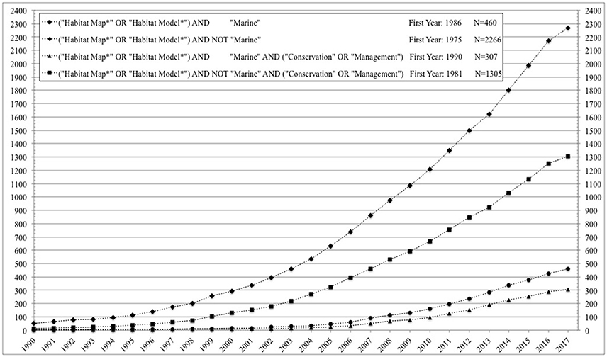
Figure 1. Cumulative number of publications (articles or reviews) listed in the Scopus database mentioning specific keywords (see legend) in their title, abstract, or keywords, in July 2017.
Scientists and decision-makers involved in conservation and management also grew an interest for marine habitat mapping (e.g., Ross and Howell, 2013; Selgrath et al., 2016): while habitat maps can serve many purposes, statistics show that habitat mapping studies are most often directly or indirectly set in a context of conservation or management (Figure 1), and the meta-analysis showed that 16 review articles were written on the use of marine habitat mapping for conservation and management between 2003 and 2016. The proportion of habitat mapping studies set in a context of conservation or management is higher in the marine environment (about 67%) than in other types of environments (about 58%) (Figure 1). These numbers are in line with observations made by Harris and Baker (2012a) for the GeoHab Atlas of Seafloor Geomorphic Features and Benthic Habitats (Harris and Baker, 2012b), in which about 64% of the case studies were performed for conservation or management purposes (e.g., baseline mapping for management, fisheries resources management, marine protected areas design). They also identified conservation groups and governments and industries that manage marine resources as the main users and clients of habitat mapping.
Since marine habitats are broadly defined as distinct areas characterized by a combination of specific chemical, physical and/or biological characteristics (Lecours et al., 2015), their study is by definition a multidisciplinary endeavor. By its spatial and data-driven natures, marine habitat mapping strongly relies on spatial sciences (Cogan et al., 2009). Through the development of geospatial technologies and methods (e.g., GIS, remote sensing, spatial analysis), spatial sciences have become very accessible to a wide range of scientists involved in marine habitat mapping (e.g., biologists, ecologists, geologists, oceanographers) (e.g., Valavanis et al., 2008; Reshitnyk et al., 2014). The near ubiquitous use of these technologies and methods in the habitat mapping workflow makes its practices directly influenced by spatial concepts such as spatial scale, spatial autocorrelation, and spatial heterogeneity (Lecours et al., 2015). However, the scientists from different disciplines framing the questions related to the study of marine habitats, and the managers and decision-makers applying the answers are frequently not trained in the theories behind the many tools and techniques that migrate from the spatial sciences to habitat mapping. While spatial scientists have been studying some of these concepts—some of which are addressed in this paper—for a long time (Table 2), the understanding of their role and their integration in the habitat mapping workflow have received scant attention in the past. For example, of the 460 marine habitat mapping studies from Figure 1, very few of them had the terms “data quality” (0.7%), “spatial scale” (7.4%), or “temporal scale” (1.3%) in their title, abstract, or keywords. This problem is rooted in a disconnection between marine habitat mapping practioners and the sciences (e.g., geography, geomatics) that provide the spatial concepts that partly support habitat mapping practices. The fast pace at which tools and techniques are developing may commonly prevent scientists not directly involved in spatial sciences from remaining apprised of new developments in these fields. In addition, the development of easily accessible GIS tools bring hidden dangers by facilitating non-critical use by end-users who may have limited appreciation of spatial concepts (Lecours et al., 2016b). Because the tools are made to be intuitive, they often do not require end-users to fully understand the characteristics of the underlying processes and parameters implemented in the tools, and of the spatial data that form the basis for analysis. The scientific concepts and foundations are thus often hidden behind increasingly “black-box,” user-friendly tools. The combination of these factors leads to the danger of inappropriate use of geospatial data and tools and the lack of appropriate consideration of important spatial concepts, from which misinformed and potentially erroneous interpretations or inferences could be made in contexts like conservation and management. There is a need to reunite the marine habitat mapping and spatial sciences communities to encourage the production of habitat maps that take into account the relevant spatial concepts to increase robustness and validity of habitat distribution and predictions. The remainder of this paper attempts to do so by reviewing four concepts from spatial sciences that may cause issues when not properly considered in marine habitat mapping for conservation and management.
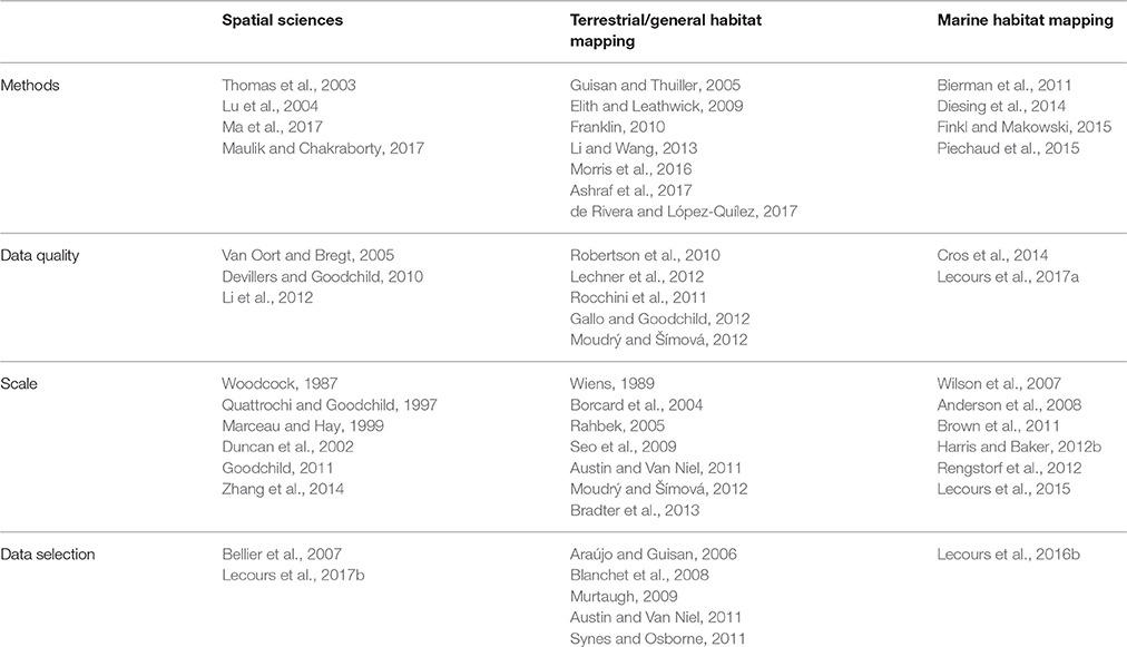
Table 2. Examples of publications that discuss issues associated with methods selection, data quality, scale, and data selection, with their context.
Warning: Vectors of Map Variability
This section discusses four vectors of map variability that need to be considered when producing habitat maps: methodology, data quality, scale, and data selection. As highlighted in Table 2, each of these topics have been previously reviewed or discussed in length in different contexts, including the spatial sciences and both terrestrial and marine habitat mapping. However, these reviews and discussions were often not directly set in a marine conservation and management context. In order to prevent repetition with published work, this section solely focuses on the impacts of these issues on marine conservation and management (as opposed to focusing on the issues themselves). More information on these four issues can be found in the literature listed in Table 2.
Methodology
One of the first elements that requires a critical decision is the methodology that is used to create a map or model. This can be approached from two perspectives: the data collection methods and the map production methods. Developments in data collection techniques in the last few decades have increased the types, amount and quality of data that can be collected for marine environmental characterization, particularly in terms of remotely sensed data (Brown et al., 2011; Kachelriess et al., 2014; Lecours et al., 2016b). Despite all the benefits associated with new data collection tools, Wells et al. (2016) have warned against an over-dependence on technology, which can create a false feeling of trust in the data (see Section Data Quality) to the detriment of collecting appropriate ground-truthing data to verify the maps. Ground-truthing should always be performed, whether it is to train a model, to validate a final map, or to give an ecological interpretation to patterns in the data. Data collection methods and sampling patterns have to be carefully selected as they define key elements, such as the type of information collected and the observational scale of the data (Bradshaw and Fortin, 2000; Lecours et al., 2015), in addition to logistical elements like cost and surveying time. Even before any maps are made, these elements directly impact the information provided to decision-makers regarding the surveyed environment (Pinn and Robertson, 2003). Data collection methods and sampling patterns also need to align with the goals and needs of the mapping exercise, or, in other words, the intended use of the map.
In terms of the map production approach, it has been shown in many studies that given the same context and data, using different mapping and modeling techniques produces different outcomes (e.g., Keil and Hawkins, 2009; Marmion et al., 2009; Murtaugh, 2009), which can inform conservation and management differently (Jones-Farrand et al., 2011). While the type of approach is selected based on the objectives of the maps and the available data (Brown et al., 2012), the specific method is open to subjectivity from mapmakers or modelers. For instance, when performing unsupervised (i.e., self-classifying, without training data) classifications on a set of data, it is unclear whether algorithms of the “ISO cluster” family perform better or worse than algorithms from the “K-means” family, and this would presumably depend on the phenomenon being mapped. While Table 3 gives examples of methods that have been applied in marine habitat mapping studies, Figure 2 shows that even when two algorithms are from the same family, they can still introduce differences in mapping outcomes. In this figure, the reference map was computed using the “k-Means” unsupervised classification algorithm from WhiteBox GAT (v.3.4 “Montreal”), and the altered map was produced with the “Modified k-Means” algorithm from the same software. While the two algorithms are very similar, they classified 4.1% of the entire area differently. Algorithms that are not from the same family produce much more discrepancies in habitat distributions.
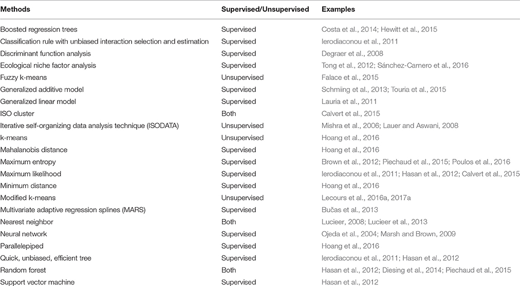
Table 3. Examples of classification methods used in marine habitat mapping and species distribution modeling, with examples.
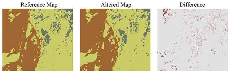
Figure 2. Example of how different methods can produce different outcomes. The input data were bathymetric data, backscatter data, and topographic data (i.e., slope, easterness, northerness, and relative deviation from mean value) (see Lecours et al., 2016b). The area shown is a 13.4 km by 12 km subset of the German Bank study area presented in Brown et al. (2012) and Lecours et al. (2016b).
The literature comparing different methods is much more extensive for species distribution modeling, likely because of the constant development of new methods (e.g., Elith et al., 2006; Phillips et al., 2006; Crase et al., 2012). However, the problem is not a lack of methods, but rather a question of which method produces the most appropriate results for an intended use (Elith and Graham, 2009; Jones-Farrand et al., 2011). Unfortunately, no consensus has ever been reached on which modeling techniques are best, and it has been recognized that little guidance is provided to users (Elith and Graham, 2009; Jones-Farrand et al., 2011). The reality is that no approach is universally applicable (Hamil et al., 2016). However, map producers should be able to explain why a particular method was selected and how that method helps achieve the objectives of the process. Model comparisons studies showing how different techniques produce different outcomes should be limited until they start addressing why techniques perform differently (Elith and Graham, 2009): a better understanding of the mechanics of the modeling techniques will enable the proposition of guidelines to help map producers make a more informed choice of methods.
From a conservation and management perspective, the lack of guidance in method selection has been criticized based on its importance in the planning process (Jones-Farrand et al., 2011). Differences in sampling methodologies make planning difficult (Griffiths et al., 1999) and prevent transparency, comparability and repeatability. Critiques on the lack of standardization of methods for robust decision-making have been made for many years in both terrestrial and marine conservation (e.g., Laffoley and Hiscock, 1993; Griffiths et al., 1999; Cork et al., 2000). While those early critiques may have contributed to encouraging many countries to standardize mapping and decision-making processes (Guarinello et al., 2010; e.g., Buhl-Mortensen et al., 2015), judgment calls are still being made (Lengyel et al., 2008; Levin et al., 2014); the inconsistency in the use of different methods is still considered a challenge for decision-making and the development of robust conservation and management measures (Crossman et al., 2012; Gjerde et al., 2016). The most important outcome of standardization is arguably the comparability of the resulting maps (Howell, 2010; Davies et al., 2015) which enables, for instance, the systematic identification of priority conservation targets based on common criteria (Laffoley and Hiscock, 1993; Edgar et al., 2008), comparisons across geographic areas (Borja et al., 2014), and multi-temporal assessments as verification process to ensure that conservation objectives are reached (Bisack and Magnusson, 2016; Wells et al., 2016).
Standardization of protocols from data collection to decision-making can minimize political bias and ensure that conservation decisions are objective, data-driven and grounded in sound science (Edgar et al., 2008). The main challenge for standardization is the scale of management (see Section Scale): while many individual countries are developing their own protocols (Guarinello et al., 2010), calls are being made for common frameworks for instance across the European Union (Lengyel et al., 2008; Levin et al., 2014; Howell et al., 2016) and at the international level for areas beyond national jurisdiction or for the protection of migratory species (Di Sciara et al., 2016; Gjerde et al., 2016; Wenzel et al., 2016). To save time, costs and efforts, each level of protocol should be in line with the others, which is quite challenging considering that no solution is universally applicable at all scales and in all contexts (but see Section Toward a Digital Resilience in Marine Conservation and Management).
Data Quality
Another element that can significantly affect the outcomes of mapping and modeling processes is data quality. Data quality encompasses concepts of accuracy, precision, and uncertainty, and can be of different types including spatial, thematic, and temporal. The different components of data quality have been reviewed in a number of publications (e.g., Jager and King, 2004; Barry and Elith, 2006; Devillers et al., 2010; Moudrý and Šímová, 2012; Levin et al., 2014), and I thus focus here on their impacts on habitat maps in a conservation context.
When integrated into a modeling exercise, each dataset carries its own uncertainty and errors (Heuvelink, 1998). For instance, species distribution data can be uncertain and associated with positional and thematic accuracy (Edgar et al., 2008; Moudrý and Šímová, 2012), while bathymetric data can also be associated with uncertainty (Lecours and Devillers, 2015) and affected by different kinds of artifacts (Hughes-Clarke, 2003; Yang et al., 2007). Principles of error and uncertainty propagation make errors and uncertainty likely to impact any subsequent analyses, including mapping and modeling (Arbia et al., 1998; Heuvelink, 1998). The algorithms and modeling techniques themselves, through their structure and parameters, can also introduce uncertainty in the final outputs (Heuvelink, 1998). While the concepts associated with error and uncertainty propagation have been studied in the geospatial literature (Fisher and Tate, 2006; Wilson, 2012), the attempts to raise end-users' awareness in fields like ecology and environmental modeling have failed (Brown and Heuvelink, 2007; Devillers et al., 2010). With a few exceptions from the terrestrial literature (e.g., van Niel and Austin, 2007; Livne and Svoray, 2011), and despite repeated calls for the appropriate consideration of error and uncertainty propagation in environmental modeling and mapping (Rocchini et al., 2011; Beale and Lennon, 2012; Lechner et al., 2012), these concepts have yet to be better implemented, especially in a marine context (Lecours et al., 2015).
It has been argued that there is a general lack of concern about data quality from both mapmakers and end-users (Devillers et al., 2010), to the point where data quality issues are ignored and tolerated by conservation planners as an inherent part of data (Tulloch et al., 2016). Tulloch et al. (2016) found out that conservation planners prefer simplicity of maps to their accuracy, which is understandable to a certain point because it is easier to make policy from a simple map than from a complex one, or one with contingencies (Borja, 2014). However, errors and uncertainty can result in inaccurate representation of the environments, and thus inaccurate maps (Wintle et al., 2005, Figure 3). While looking at the impact of artifacts in bathymetric data on the habitat mapping workflow, Lecours et al. (2017a) found that poor data quality affects the outcome of the mapping process, although in an often unpredictable way: the presence of artifacts can sometimes artificially increase the measured map accuracy and model predictive power while in other cases it can decrease them. A lack of awareness and understanding of the concepts associated with data quality can in turn lead to misinformed conservation and management decisions (Rondinini et al., 2006; Beale and Lennon, 2012; Katsanevakis et al., 2012) with dire results for biodiversity (Regan et al., 2005). For instance, it can become an issue when prioritizing conservation decisions (Tulloch et al., 2016): if one area is identified as being a slightly more important target for conservation than another, but the first is associated with a higher level of uncertainty, which one should be prioritized?
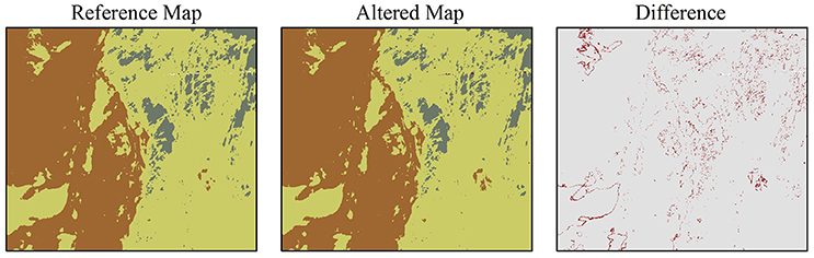
Figure 3. Example of how using data of different quality can produce different outcomes. The reference map is the same as in Figure 2. The altered map used bathymetric data impacted by artifacts caused by a 0.25 s mis-synchronization in the surveying system (see Lecours et al., 2017a). The presence of artifacts made the classification vary of 2.1%. Motion artifacts, which are often present in bathymetric data, can cause much more impacts in mapping outcomes than time artifacts.
Some methods exist to estimate the quality of resulting maps. For example, when using unsupervised classifications of environmental data to identify distinct habitats, the classification accuracy can be evaluated using confusion matrices (e.g., Brown et al., 2012; Lecours et al., 2016a). Confusion matrices identify commission and omission errors, or the level of agreement and disagreement between the classification results and ground-truth data. Commission errors occur when a species or habitat is mistakenly identified as present while omissions errors occur when they are mistakenly identified as being absent. Rondinini et al. (2006) identified the implications for conservation of these two types of errors: commission errors may lead to areas being identified as relevant for conservation when they are not, while omission errors may miss the identification of relevant areas for conservation, thus underestimating the needs for protection. Consequently, these errors affect the adequacy and efficiency of conservation, and the representativeness and comprehensiveness of the areas that should be targeted or prioritized (Rondinini et al., 2006).
Modeling error and uncertainty propagation through an entire workflow is challenging because it is unclear how the quality of each individual dataset influences the processing and adds to the uncertainty of the modeling technique. In addition, it is not fully understood how the combination of individual components of data quality (e.g., positional accuracy, thematic accuracy) can be translated into one overall measure of quality. Perhaps it cannot, but different approaches exist in other fields to combine multiple metrics (e.g., Borja et al., 2014) that could likely be adapted to combine different components of data quality. One of the current problems is transparency: it has been argued that readily available data could affect the accuracy of conservation planning outcomes (Rondinini et al., 2006) by introducing uncertainty and subjectivity in the process (Larsen and Rahbek, 2003). However, subjectivity would be removed if complete metadata including quality information would be associated with each dataset, enabling a robust data quality assessment. Rocchini et al. (2011) and Diesing et al. (2016), among other authors, have highlighted the need for maps of ignorance, i.e., maps that spatially display uncertainty and errors associated with the primary maps and can assist decision-makers in assessing the reliability of predictions. While some tools have been provided to assess individual components of data quality [e.g., Combined Uncertainty Bathymetric Estimator (Calder and Mayer, 2003); Data Uncertainty Engine (Brown and Heuvelink, 2007)], there is a need for a user-friendly tool that enables the combined quantification of errors and uncertainty at the end of an analysis workflow. In addition, an analysis of data quality of each dataset at the beginning of the mapping workflow would facilitate decisions regarding the validity of data integration in the exercise. Research in geovisualization and cognition also needs to be done to develop a geovisualization tool that would enable a clear spatial representation of uncertainty and errors associated with habitat maps and models. Such a tool would have to be suitable for decision-makers without generating negative perceptions of uncertainty and errors in the end-users: issues of data quality are known to be a sensitive topic in management as a lack of understanding of these issues can lead managers to disqualify science on the sole basis that uncertainty and errors were identified or acknowledged.
Awareness of data quality issues in conservation and management must be improved, and many actions can be taken to move toward resolving this issue. First, there should be a focus on increasing awareness in the end-users community and increasing the connection between data producers, mapmakers and end-users (Cork et al., 2000; Devillers et al., 2010). In addition, sources of errors and uncertainty and known limitations of data and methods should be acknowledged and this information should be associated with maps and models. Relating to methods (as discussed in Section Methodology), Jones-Farrand et al. (2011) warned against the use of only one habitat model, indicating how risky it can be for conservation planning. They advocate for the comparisons of outputs from different models (e.g., Figure 2) to enable the identification of areas with stronger potential for conservation and those associated with more uncertainty, thus holding more risks for conservation. As they explain, combining multiple maps can reduce uncertainty, increase efficacy of conservation when maps agree with each other, and increase understanding of the data and process when maps do not agree with each other. Ensemble techniques are promising methods to implement these solutions (Diesing and Stephens, 2015; Robert et al., 2016). In all cases, mapmakers should explicitly report commission and omission errors and their meaning when relevant (Rondinini et al., 2006; Borja, 2014), and in modeling processes probabilistic outputs accounting for model uncertainty should be provided (Tulloch et al., 2013). Finally, all of this information should be incorporated into the decision-making processes (Moilanen et al., 2006; Tulloch et al., 2016): Levin et al. (2014) argued that the lack of data quality information is among the most significant impediments to adequate conservation efforts.
Scale
The issues associated with thematic, spatial, and temporal scales have been widely discussed in the ecological (e.g., Levin, 1992; Schneider, 2001; Hobbs, 2003) and geospatial literatures (e.g., Stone, 1972; Atkinson and Tate, 2000; Goodchild, 2011), including a recent review by Lecours et al. (2015) on scale in marine habitat mapping. Here, I focus on how scale impacts mapping outcomes, and the implications of scale for decision-making. Planning processes and outcomes are directly affected by scale (Rondinini et al., 2006; Wolff et al., 2016): measuring the same phenomenon with data at different scales produces different patterns (Keil and Hawkins, 2009; Ross et al., 2015) which provides different information to decision-makers. For instance, Figure 4 shows that by generating the bathymetric and backscatter surfaces at 25 and 100 m spatial resolution instead of 10 m resolution, the representations of the distribution of habitats vary by 13.2% (482 km2) and 31.3% (1,144 km2) respectively. While generating sets of species distribution models using the same data but at different spatial resolutions, Seo et al. (2009) found that both the accuracy of the models and the spatial distribution of predictions varied with changing scale.
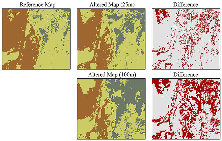
Figure 4. Example of how using the same data at different scales can produce different outcomes. The reference map is the same as in Figure 2. The two altered maps were computed using the same methods and the same data but generated at 25 m (top) and 100 m (down) spatial resolution.
Ecological patterns and processes occur at multiple scales (Buhl-Mortensen et al., 2015) and by often focusing on single scales current habitat mapping practices regularly fail to capture multiscale environmental drivers (Eidens et al., 2015; Lecours et al., 2015). The situation becomes more complex when the maps are used for conservation and management as the scale of management has to match the ecological scales in order to be effective. While many authors have recommended shifting habitat mapping practices toward multiscale analyses, Battista et al. (2017) suggested also moving toward multiscale conservation and management planning that involves self-replication across scales. If implemented properly, this would solve a constant dilemma in conservation regarding the choice between protection of large comprehensive areas or networks of smaller areas (Di Sciara et al., 2016). However, cross-scale interactions in social-ecological systems and exercises—like in conservation and management—are complex and identified as a key challenge (see Cash et al., 2006). While issues of scale are well-known across sciences, it is unclear how different stakeholders with different backgrounds perceive and interpret the concept of scales (Apostolopoulou and Paloniemi, 2012). This is more acute in conservation and management that is the product of transdisciplinary collaboration and that requires the appropriate matching of methodological (observational and analytical), ecological, social (i.e., the scale at which people or industry use the resources) and management scales (Edgar et al., 2008; Levin et al., 2014). Mismatches between the natural and social scales have been identified as causes for failures in conservation and management (Crowder et al., 2006; Cumming et al., 2006). Much work remains to fully understand the underpinnings of attempting to match the many different types of scale to produce sound science, better inform decisions, and answer the needs of the different stakeholders. As stated by Apostolopoulou and Paloniemi (2012), “biodiversity conservation is an illuminating case for exploring scale challenges, given that biodiversity is by definition a multiscale phenomenon, and conservation expansion has at its core several emerging multiscalar challenges.”
The incorporation of scientific knowledge regarding ecological scale into conservation planning has been identified as one of the most urgent scale challenge (e.g., Apostolopoulou and Paloniemi, 2012). However, like for data quality, the lack of translation between theory and practice is problematic; while there are methods to properly account for scale in ecological mapping and modeling (e.g., Detto and Muller-Landau, 2013; Matteo Sánchez et al., 2014), practical solutions are often not implemented in user-friendly, easily accessible software (Hamil et al., 2016). Until such tools become available, scale information should always be explicitly stated in the metadata and conservation and management plans to effectively support decision-makers (Wolff et al., 2016).
Data Selection and Fitness for Use
Finally, in addition to data scale and quality, data selection itself requires critical evaluation when being integrated into the habitat mapping workflow for use in conservation and management. While this may seem obvious, data content is a matter that needs to be carefully approached: it has been reported that data for marine characterization are not always carefully selected, with data being selected primarily based on availability rather than ecological meaning and fitness-for-use (Peterson et al., 2011; Tulloch et al., 2016; Lecours et al., 2017a). It is evident that selecting different variables, for instance broad-scale currents instead of fine-scale substrate types, is likely to produce different maps and influence models differently. However, it has been shown that significant variations occur even when selecting different variables that describe the same environmental characteristics. Figure 5 provides an example in which significant changes in habitat distribution were observed by simply replacing one of eight variables by another one that was highly spatially correlated with it (r = 0.96). Based on that correlation, it would be intuitive to not be expecting much change in mapping outputs. However, 15.5% (566 km2) of the study area was mapped differently. When more than one variable is replaced, the changes can be more significant, with changes in habitats' spatial distributions that can reach as much as thousands of square kilometers (Lecours et al., 2016a). One of the main solutions that has been discussed widely in the ecological literature is to select variables with an ecological meaning for the studied area, species or habitat (Howell, 2010; Borja et al., 2014; Lecours et al., 2015, 2016a). However, this makes comparability of maps in a broader context difficult; as previously discussed, there is no universal approach and variable selection is site- and case-specific (Pitcher et al., 2012).
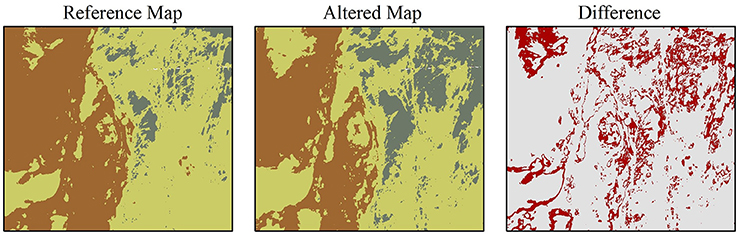
Figure 5. Example of how replacing only one variable as input to the mapping process can produce different outcomes. The reference map is the same as in Figure 2. The altered map was produced with all the same data layers, except that the slope data was replaced by rugosity data. The slope and rugosity layers are highly spatially correlated in this study area (r = 0.96).
Selecting which variables to use amongst those for which data are available is different than selecting which variables should be used: easily accessible datasets often cause an over-simplification of habitat maps by encouraging the lack of consideration of important variables. The marine environment is a complex, multidimensional environment, and mapping exercises often do not include a comprehensive set of pertinent data such as physical, geological, biological, and anthropogenic characteristics (Guarinello et al., 2010; Boyd and Brown, 2015). Even more challenging is the integration of appropriate ecological phenomena and interactions that limits our ability to use this crucial information in decision-making, whether it is the synergistic and antagonistic effects of drivers on species distributions (Boyd and Brown, 2015), habitat edges and transitions (Pinn and Robertson, 2003; Ries et al., 2004), or the addition of temporal variability and the third dimension (i.e., depth of phenomenon rather than depth of the seafloor, see Duffy and Chown, 2017). It is time to recognize that in order to improve the representation of marine habitats, establishing or predicting their spatial extent and distribution may not be enough (Spalding et al., 2016). When characterizing the environment for conservation and management, we need to recognize the importance of elements such as life history (Kindsvater et al., 2016), prey-predator dynamics (Chakraborty et al., 2013), community ecology (Pitcher et al., 2012), population biology (Sherman et al., 2016), structure and dynamics (Borja et al., 2014), connectivity (Hilário et al., 2015), dispersal (Beier et al., 2011), sensitivity to changes (Borja et al., 2014), and ecosystem services (Spalding et al., 2016).
While I recognize that many of these elements do not necessarily lend themselves well to static cartographic representation, we need to work with cartographers and other spatial scientists toward finding a solution to do so. To better understand how we can achieve such complex integration of variables, more research and data are needed (Broderick, 2015; Buhl-Mortensen et al., 2015; Hilário et al., 2015), in addition to cross-disciplinary collaborations that will improve the quantity and quality of information available for decision-making (Lent, 2015; Bisack and Magnusson, 2016). A promising endeavor in that vein is the Ecological Marine Units (EMUs) project (Sayre et al., 2017), which offers a baseline three-dimensional global map of marine ecosystems. Finally, habitat mapping methods that give a more accurate representation of the marine environment should be explored. For instance, changes in habitat types are often more characterized by gradual changes driven by environmental gradients than by hard demarcation lines; many traditional habitat mapping methods do not capture the presence of these mixed, transitional habitats (Pinn and Robertson, 2003), an issue also highlighted in the terrestrial literature (Ries et al., 2004). However, habitat edges are ecologically important and their study has potential for improving understanding of spatial patterning in ecosystems and therefore can inform conservation and management (Ries et al., 2004). Some classification methods emerging from concepts of fuzzy logic hold great promises in improving representation of habitat edges and should be further explored (Kobryn et al., 2013; Lecours et al., 2015).
Toward a Digital Resilience in Marine Conservation and Management
So far, this paper has highlighted impediments to a valid, appropriate use of marine habitat maps in the context of marine conservation and management. Methods and data selection, scale, and data quality significantly influence the mapping process, its outcomes, and consequently the decisions that are being supported by the maps. In this section, I discuss the potential to use interactive and collaborative GIS to encourage the conservation and management community, from data collectors and mapmakers to decision-makers, to move toward a digital resilience. Digital resilience involves data and tools that are “freely accessible, interchangeable, operational, of high quality, and up-to-date” (Wright, 2016). In a context of human adaptation to change, Wright (2016) discussed how innovations in information technologies and analyses assist in decision-making and help people become more resilient. The author made three recommendations that I believe can be transferred to the context of habitat mapping for marine conservation and management and can help move toward resolving some of the issues identified in this paper. The recommendations are to “ (1) create and implement a culture that consistently shares not only data, but workflows and use cases with the data, particularly within maps and geographic information systems or GIS; (2) use maps and other visuals to tell compelling stories that many different kinds of audiences will understand and remember; and (3) be more open to different kinds of partnerships to reduce project costs, yield better results, and foster public awareness and behavioral change.” In this section, I propose GIS environments as a supporting tool for the implementation of these recommendations in a habitat mapping context.
Interactive GIS Framework to Improve Critical Use of Maps in Marine Sciences
Many of the components of marine habitat mapping that I have problematized and discussed in this paper could be better integrated in the habitat mapping workflow, and thus help to ground decision-making in sound science, if the maps and data were interactive and embedded in a GIS environment (Levin et al., 2014). In the last 25 years, innovations related to GIS have contributed considerably to developments in marine habitat mapping (Wright and Heyman, 2008; Brown et al., 2011). Within a GIS environment, spatial analytical techniques can be combined with environmental data and in situ observations to enable accurate quantification and representation of habitats, providing a framework for mapping the distribution of species and interpreting spatial patterns in biodiversity (Brown et al., 2011; Lecours et al., 2015). In addition, existing GIS tools provide options for the implementation of many habitat mapping approaches, including tools based on concepts of fuzzy logic or landscape ecology theory. In terms of science communication, GIS environments facilitate the visualization of maps and data, and queries on those maps and data and their associated metadata. While most conservation and management decision-making exercises are currently assisted by one or a few static maps (Leslie, 2005), the use of GIS in facilitating dynamic interaction with multiple maps could help resolve the issues discussed in this paper: behavioral experiments have shown that the use of GIS to analyze and interpret data and maps can improve decision-making (Crossland et al., 1995). In addition, it is recognized that GIS-based spatial decision-support tools remain among the best options for environmental decision-making (Andersen et al., 2004).
Characterized by three main components, namely database management, data analysis, and mapping and geovisualization (Table 4), GIS developed specifically for assisting decision-making in marine conservation and management could help increase awareness about the importance of varying methods, data quality, scale and data selection, and move toward resolving issues associated with them. First, geodatabases can facilitate data selection by regrouping available data and identifying gaps in relevant data. In addition, geodatabases enable the proper integration of metadata for each dataset, including information on data quality and scale. In terms of analysis, habitat mapping and modeling tools (e.g., different algorithms for unsupervised classifications, MaxEnt, boosted regressions) can be integrated within GIS environments, in addition to proper tools for error and uncertainty propagation analysis. By combining the different algorithms and tools in one computing environment, multiple scenarios could be run on the data and compared to assess the reliability of predictions and maps, as previously suggested. In terms of mapping, GIS offer versatility in visualizing individual datasets, including spatial representations of errors and uncertainty. In addition, GIS offer a scalable environment, which can be useful for conservation planners that may need broader-scale maps to serve as vision statements at the same time as finer-scale maps to plan site-specific interventions (Beier et al., 2011). GIS also allow the exploration of ways to represent the four-dimensional nature of the environment, whether it is for accounting for depth in the study of pelagic species or for the temporal component of migration (Bentlage et al., 2013; Kaplan et al., 2014). Tools to help make individual maps or a combination of maps that tell a story could also be incorporated in such GIS (Wright, 2016), and all potential outcomes could be interrogated by decision-makers retrieving different types of information (e.g., uncertainty associated with a result, classification results for one area but given by different models). Finally, GIS like this would be based on an adaptive framework wherein data, tools, maps, and models could be iteratively updated and refined with new developments. This would offer replicable and transparent options for processing and analysis, enabling valid comparisons to be made.
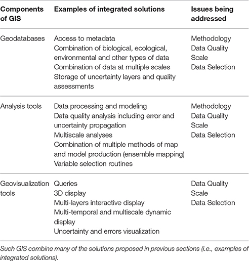
Table 4. The different components of GIS that make them potential candidates for informing decision-making in marine conservation and management while facilitating awareness on the different issues highlighted in this paper.
Such GIS would address the second recommendation made by Wright (2016) by enabling the production of different visuals (e.g., story maps) to effectively communicate the relevant information to the appropriate audiences. Furthermore, it would be possible to address Wright's two other recommendations by establishing specific management guidelines for these systems. These GIS should be in line with the open-access, data-sharing movement (Sedberry et al., 2011; Borja, 2014; Levin et al., 2014), by being accessible to anyone, by making data and tools accessible to anyone, and by allowing everyone to contribute data and tools. Gjerde and Rulska-Domino (2012) suggested the creation of an internationally accepted advisory body for providing scientific and technical advice in conservation, which could be in charge of such GIS. Similar to the controlled environment of OpenStreetMap (Haklay and Weber, 2008), data and tools would be quality-controlled before being integrated into the systems. Whether members of these GIS communities or members of their advisory body would perform this quality control is up for debate among the different stakeholders and may vary according to the needs of different conservation mandates. A collaborative effort from different researchers across a variety of fields and jurisdictions would also be needed (Gjerde and Rulska-Domino, 2012; Dunstan et al., 2016; Jay et al., 2016) to ensure sharing of resources and proper representation of ecological processes that occur across and beyond political jurisdictions (Poiani et al., 2000). As highlighted by Rudd (2014), such efforts would benefit from the involvement of social scientists. Suitable guidelines would need to be established to avoid conflicts between natural and social scientists, who may have different priorities and definitions (e.g., in terms of data quality or validity) (see discussion in Rudd, 2014). In addition, a committee on ethics would be required within the advisory body. For example, the inclusion of social data into a public geodatabase involves ethical questions related to data ownership and access.
While such GIS may seem utopian, user-contributed websites like OpenStreetMap (Haklay and Weber, 2008), collaborative global initiatives like the Census for Marine Life (Alexander et al., 2011; Vermeulen, 2013), projects like DEVOTES (http://www.devotes-project.eu), OpenTopography (http://opentopography.org) or the production of Ecological Marine Units (http://www.esri.com/ecological-marine-units), and other calls for GIS to support conservation and management (e.g., Levin et al., 2014) put the proposed GIS in the realm of feasibility, if the different stakeholders come together with the appropriate resources to make it happen. In addition, there recently has been a rise in similar GIS of smaller amplitude and complexity (e.g., Tyberghein et al., 2012; Karnatak et al., 2014).
Impediments to a Successful Implementation
While marine ecosystems and sciences are complex, decision-makers and the public are drawn to simple scientific communication (Borja et al., 2014; Hilário et al., 2015; Tulloch et al., 2016), and sound and informed choices in conservation require effective communication that reaches the multiple audiences involved in the planning process (Fischhoff, 2013; Wright, 2016). We have a responsibility as scientists to make our results and recommendations understandable for the stakeholders and to fit their needs (Groffman et al., 2010; Duarte, 2014; Broderick, 2015; Mea et al., 2016). The proposed idea of open-access GIS that enable geodatabase building, geovisualization tools, data quality control, and multiple habitat mapping options is not a panacea. First, GIS have their own set of issues, including those associated with mapping and identified in this paper (e.g., data quality). The advantage of GIS over static maps is the possibility of showing multi-dimensional datasets that can include data quality information, metadata, temporal variations, etc. Second, we cannot discount the possibility that such GIS could be manipulated to display misleading information, whether it is for a political purpose or simply due to a lack of understanding of tools or data. Then, the most effective solution still resides in improving scientific and geospatial literacy among the different people involved in conservation and management efforts (e.g., scientists, decision-makers, politicians, the public). It is thus crucial to keep raising awareness of the high variability of maps and models, and to continue proposing solutions to better consider the issues discussed in this paper. By including all who are involved at each step of conservation and management efforts, and by working all together, we can start reducing the gap between the priorities of scientists, society and policy-makers, and ensuring that conservation policy is based on sound scientific evidence (Adams and Sandbrook, 2013; Rudd, 2014; Rose, 2015).
Conclusion
Maps are critical to effectively communicate information about the marine environment to the relevant decision-makers. However, maps are highly variable and they depend strongly on a variety of elements like the methodology used to produce them, the data that were selected to make them, and the scale and quality of these data. These elements have to be acknowledged and appropriately dealt with as they are inherent to map production and may cause issues for conservation and management planning (Tulloch et al., 2016). In addition, they are all related; for instance, there is often a relationship between data quality and spatial scale (Braunisch and Suchant, 2010; Lecours and Devillers, 2015), and between data quality and model selection (Rondinini et al., 2006).
This contribution to the literature was written keeping this antinomy in mind, which can be summarized with a quote from Box and Draper (1987), who wrote that “essentially, all models are wrong, but some are useful,” and a subsequent quote by Devillers et al. (2010): “all spatial data are wrong, but some are useful.” Despite their utility and their strong potential for clear and understandable communication, maps and models will always require scientific expert advice and interpretation (Reiss et al., 2015): we must be transparent with the mapping techniques and data, and recognize their respective limitations (Kindsvater et al., 2016). In addition, understanding the different trade-offs involved in the mapping process is critical when maps and models are used in marine conservation and management planning (Langford et al., 2009). However, stakeholders involved in these practices are frequently not trained to critically evaluate the maps they are presented, in addition to the underlying methods and data. Mapmakers also need to consider the end-use of the maps in order to make appropriate decisions when producing the maps. While geographers and other spatial scientists have been studying concepts of scale and data quality for a long time, the understanding of their role and integration in the marine habitat mapping workflow has received scant attention in the past. There is an urgent need to improve our understanding of how these concepts influence the representation of ecosystems and habitats, and to raise awareness among scientists, decision-makers, and other stakeholders about their implications. Having a strong, consistent, transparent, repeatable, and science-based protocol for data collection and mapping that is truly representative of the environment and ecological patterns and processes is essential for effectively supporting decision-makers in developing conservation and management plans. To reach this goal, I recommend: (1) standardizing methods, (2) implementing multiscale data collection and analyses, (3) using ensemble mapping and prediction techniques, (4) quantifying and spatially representing errors, uncertainty, and their propagation, (5) explicitly addressing scale components in analyses and interpretations, (6) producing complete metadata, and (7) developing a digital resilience through the integration of interactive and dynamic GIS in support of decision-making.
Author Contributions
The author confirms being the sole contributor of this work and approved it for publication.
Conflict of Interest Statement
The author declares that the research was conducted in the absence of any commercial or financial relationships that could be construed as a potential conflict of interest.
Acknowledgments
Many thanks are due to Emma LeClerc for her insightful comments on the different versions of this manuscript, and to Benjamin Misiuk for his assistance with classification methods. Publication of this article was funded in part by the University of Florida Open Access Publishing Fund. The ideas for this paper emerged from my work and enlightening discussions with Drs. Rodolphe Devillers, Craig Brown, Vanessa Lucieer, and Evan Edinger, and I thank them for that. A data-based presentation on some of the elements presented in this paper was given at the 4th International Marine Conservation Congress, under the title “Assessing marine habitat maps' sensitivity to variable selection and data quality,” by VL, R. Devillers, C. Brown, V. Lucieer, and E. Edinger. I would also like to thank the two reviewers for their comments that significantly improved this manuscript.
References
Adams, W. M., and Sandbrook, C. (2013). Conservation, evidence and policy. Oryx 47, 329–335. doi: 10.1017/S0030605312001470
Alexander, V., Miloslavich, P., and Yarincik, K. (2011). The census of marine life – evolution of worldwide marine biodiversity research. Mar. Biodivers. 41, 545–554. doi: 10.1007/s12526-011-0084-1
Allen, G. R. (2008). Conservation hotspots of biodiversity and endemism for indo-Pacific coral reef fishes. Aquatic Conserv. Mar. Freshw. Ecosyst. 18, 541–556. doi: 10.1002/aqc.880
Andersen, M. C., Thompson, B., and Boykin, K. (2004). Spatial risk assessment across large landscapes with varied land use: lessons from a conservation assessment of military lands. Risk Anal. 24, 1231–1242. doi: 10.1111/j.0272-4332.2004.00521.x
Anderson, J. T., Van Holliday, D., Kloser, R., Reid, D. G., and Simard, Y. (2008). Acoustic seabed classification: current practice and future directions. ICES J. Mar. Sci. 65, 1004–1011. doi: 10.1093/icesjms/fsn061
Apostolopoulou, E., and Paloniemi, R. (2012). Frames of scale challenges in Finnish and Greek biodiversity conservation. Ecol. Soc. 17, 1–15. doi: 10.5751/ES-05181-170409
Araújo, M. B., and Guisan, A. (2006). Five (or so) challenges for species distribution modelling. J. Biogeogr. 33, 1677–1688. doi: 10.1111/j.1365-2699.2006.01584.x
Arbia, G., Griffith, D., and Haining, R. (1998). Error propagation and modelling in raster GIS: overlay operations. Int. J. Geogr. Inform. Sci. 12, 145–167. doi: 10.1080/136588198241932
Ashraf, U., Peterson, A. T., Chaudhry, M. N., Ashraf, I., Saqib, Z., Ahmad, S. R., et al. (2017). Ecological niche model comparison under different climate scenarios: a case study of Olea spp. in Asia. Ecosphere 8:e01825. doi: 10.1002/ecs2.1825
Atkinson, P. M., and Tate, N. J. (2000). Spatial scale problems and geostatistical solutions: a review. Prof. Geogr. 52, 607–623. doi: 10.1111/0033-0124.00250
Austin, M. P., and Van Niel, K. P. (2011). Improving species distribution models for climate change studies: variable selection and scale. J. Biogeogr. 38, 1–8. doi: 10.1111/j.1365-2699.2010.02416.x
Barry, S., and Elith, J. (2006). Error and uncertainty in habitat models. J. Appl. Ecol. 43, 413–423. doi: 10.1111/j.1365-2664.2006.01136.x
Battista, W., Tourgee, A., Wu, C., and Fujita, R. (2017). How to achieve conservation outcomes at scale: an evaluation of scaling principles. Front. Mar. Sci. 3:278. doi: 10.3389/fmars.2016.00278
Beale, C. M., and Lennon, J. J. (2012). Incorporating uncertainty in predictive species distribution modelling. Philos. Trans. R. Soc. B 367, 247–258. doi: 10.1098/rstb.2011.0178
Bedulli, D., Bassignani, F., and Bruschi, A. (2002). Use of biodiversity hotspots for conservation of marine molluscs: a regional approach. Mediterr. Mar. Sci. 3, 113–121. doi: 10.12681/mms.250
Beier, P., Spencer, W., Baldwin, R. F., and McRae, B. H. (2011). Toward best practices for developing regional connectivity maps. Conserv. Biol. 25, 879–892. doi: 10.1111/j.1523-1739.2011.01716.x
Bellier, E., Monestiez, P., Durbec, J. P., and Candau, J. N. (2007). Identifying spatial relationships at multiple scales: principal coordinates of neighbour matrices (PCNM) and geostatistical approaches. Ecography 3, 385–399. doi: 10.1111/j.0906-7590.2007.04911.x
Bentlage, B., Perterson, A. T., Barve, N., and Cartwright, P. (2013). Plumbing the depths: extending ecological niche modelling and species distribution modelling in three dimensions. Glob. Ecol. Biogeogr. 22, 952–961. doi: 10.1111/geb.12049
Bierman, P., Lewis, M., Ostendorf, B., and Tanner, J. (2011). A review of methods for analyzing spatial and temporal patterns in coastal water quality. Ecol. Indic. 11, 103–114. doi: 10.1016/j.ecolind.2009.11.001
Bisack, K. D., and Magnusson, G. M. (2016). Measuring management success for protected species: looking beyond biological outcomes. Front. Mar. Sci. 3:61. doi: 10.3389/fmars.2016.00061
Blanchet, F. G., Legendre, P., and Borcard, D. (2008). Forward selection of explanatory variables. Ecology 89, 2623–2632. doi: 10.1890/07-0986.1
Borcard, D., Legendre, P., Avois Jacquet, C., and Tuomisto, H. (2004). Dissecting the spatial structure of ecological data at multiple scales. Ecology 85, 1826–1832. doi: 10.1890/03-3111
Borja, A. (2014). Grand challenges in marine ecosystems ecology. Front. Mar. Sci. 1:1. doi: 10.3389/fmars.2014.00001
Borja, A., Elliot, M., Snelgrove, P. V. R., Austen, M. C., Berg, T., Cochrane, S., et al. (2016). Bridging the gap between policy and science in assessing the health status of marine ecosystems. Front. Mar. Sci. 3:6. doi: 10.3389/978-2-88945-004-6
Borja, A., Prins, T. C., Simboura, N., Andersen, J. H., Berg, T., Marques, J.-C., et al. (2014). Tales from a thousand and one ways to integrate marine ecosystem components when assessing the environmental status. Front. Mar. Sci. 1:72. doi: 10.3389/fmars.2014.00072
Box, G. E. P., and Draper, N. R. (1987). Empirical Model-Building and Response Surfaces. Hoboken, NJ: Wiley.
Boyd, P. W., and Brown, C. J. (2015). Modes of interactions between environmental drivers and marine biota. Front. Mar. Sci. 2:9. doi: 10.3389/fmars.2015.00009
Bradshaw, G., and Fortin, M. J. (2000). Landscape heterogeneity effects on scaling and monitoring large areas using remote sensing data. Geogr. Inf. Sci. 6, 61–68. doi: 10.1080/10824000009480534
Bradter, U., Kunin, W. E., Altringham, J. D., Thom, T. J., and Benton, T. G. (2013). Identifying appropriate spatial scales of predictors in species distribution models with the random forest algorithm. Methods Ecol. Evol. 4, 167–174. doi: 10.1111/j.2041-210x.2012.00253.x
Braunisch, V., and Suchant, R. (2010). Predicting species distributions based on incomplete survey data: the trade-off between precision and scale. Ecography 33, 826–840. doi: 10.1111/j.1600-0587.2009.05891.x
Broderick, A. C. (2015). Grand challenges in marine conservation and sustainable use. Front. Mar. Sci. 2:11. doi: 10.3389/fmars.2015.00011
Brown, C. J., Sameoto, J. A., and Smith, S. J. (2012). Multiple methods, maps, and management applications: purpose made seafloor in support of ocean management. J. Sea Res. 72, 1–13. doi: 10.1016/j.seares.2012.04.009
Brown, C. J., Smith, S. J., Lawton, P., and Anderson, J. T. (2011). Benthic habitat mapping: a review of progress towards improved understanding of the spatial ecology of the seafloor using acoustic techniques. Estuar. Coast Shelf Sci. 92, 502–520. doi: 10.1016/j.ecss.2011.02.007
Brown, J. D., and Heuvelink, G. B. M. (2007). The Data Uncertainty Engine (DUE): a software tool for assessing and simulating uncertain environmental variables. Comput. Geosci. 33, 172–190. doi: 10.1016/j.cageo.2006.06.015
Bučas, M., Bergström, U., Downie, A. L., Sundblad, G., Gullström, M., Von Numers, M., et al. (2013). Empirical modelling of benthic species distribution, abundance, and diversity in the Baltic Sea: evaluating the scope for predictive mapping using different modelling approaches. ICES J. Mar. Sci. 70, 1233–1243. doi: 10.1093/icesjms/fst036
Buhl-Mortensen, L., Buhl-Mortensen, P., Dolan, M. F. J., and Gonzalez-Mirelis, G. (2015). Habitat mapping as a tool for conservation and sustainable use of marine resources: some perspectives from the MAREANO programme, Norway. J. Sea Res. 100, 46–61. doi: 10.1016/j.seares.2014.10.014
Calder, B. R., and Mayer, L. A. (2003). Automatic processing of high-rate, high-density multibeam echosounder data. Geochem. Geophy. Geosy. 4, 1048–1069. doi: 10.1029/2002GC000486
Calvert, J., Strong, J. A., Service, M., McGonigle, C., and Quinn, R. (2015). An evaluation of supervised and unsupervised classification techniques for marine benthic habitat mapping using multibeam echosounder data. ICES J. Mar. Sci. 72, 1498–1513. doi: 10.1093/icesjms/fsu223
Cash, D. W., Adger, W., Berkes, F., Garden, P., Lebel, L., Olsson, P., et al. (2006). Scale and cross-scale dynamics: governance and information in a multilevel world. Ecol. Soc. 11, 1–12. doi: 10.5751/ES-01759-110208
Chakraborty, K., Das, K., and Kar, T. K. (2013). An ecological perspective on marine reserves in prey-predator dynamics. J. Biol. Phys. 39, 749–776. doi: 10.1007/s10867-013-9329-5
Cogan, C. B., Todd, B. J., Lawton, P., and Noji, T. T. (2009) The role of marine habitat mapping in ecosystem-based management. ICES J. Mar. Sci. 66, 2033–2042. doi: 10.1093/icesjms/fsp214
Cork, S. J., Clark, T. W., and Mazur, N. (2000). Conclusions and recommendations for koala conservation. Conserv. Biol. 14, 702–704. doi: 10.1046/j.1523-1739.2000.99392.x
Costa, B., Taylor, J. C., Kracker, L., Battista, T., and Pittman, S. (2014). Mapping reef fish and the seascape: using acoustics and spatial modeling to guide coastal management. PLoS ONE 9:e85555. doi: 10.1371/journal.pone.0085555
Costello, M. J. (2014). Long live marine reserves: a review of experiences and benefits. Biol. Conserv. 176, 289–296. doi: 10.1016/j.biocon.2014.04.023
Crase, B., Liedloff, A. C., and Wintle, B. A. (2012). A new method for dealing with residual spatial autocorrelation in species distribution models. Ecography 35, 879–888. doi: 10.1111/j.1600-0587.2011.07138.x
Cros, A., Venegas-Li, R., Teoh, S. J., Peterson, N., Wen, W., and Fatan, N. A. (2014). Spatial data quality control for the Coral Triangle Atlas. Coast. Manage. 42, 128–142. doi: 10.1080/08920753.2014.877760
Crossland, M. D., Wynne, B. E., and Perkins, W. C. (1995). Spatial decision support systems: an overview of technology and a test of efficacy. Decis. Support Syst. 14, 219–235. doi: 10.1016/0167-9236(94)00018-N
Crossman, N. D., Burkhard, B., and Nedkov, S. (2012). Quantifying and mapping ecosystem services. Int. J. Biodiv. Sci. Ecosyst. Serv. Manage. 8, 1–4. doi: 10.1080/21513732.2012.695229
Crowder, L. B., Osherenko, G., Young, O. R., Airamé, S., Norse, E. A., Baron, N., et al. (2006). Resolving mismatches in U.S. ocean governance. Science 313, 617–618. doi: 10.1126/science.1129706
Cumming, G. S., Cumming, D. H. M., and Redman, C. L. (2006). Scale mismatches in social-ecological systems: causes, consequences, and solutions. Ecol. Soc. 11, 1–20. doi: 10.5751/ES-01569-110114
Cvitanovic, C., Fulton, C. J., Wilson, S. K., van Kerkhoff, L., Cripps, I. L., and Muthiga, N. (2014). Utility of primary scientific literature to environmental managers: an international case study on coral-dominated marine protected areas. Ocean Coast. Manage. 102, 72–78. doi: 10.1016/j.ocecoaman.2014.09.003
Davies, J. S., Stewart, H. A., Narayanaswamy, B. E., Jacobs, C., Spicer, J., Golding, N., et al. (2015). Benthic assemblages of the Anton Dohrm Seamount (NE Atlantic): defining deep-sea biotopes to support habitat mapping and management efforts with a focus on vulnerable marine ecosystems. PLoS ONE 10:e0124815. doi: 10.1371/journal.pone.0124815
de Rivera, Ó., and López-Quílez, A. (2017). Development and comparison of species distribution models for forest inventories. ISPRS Int. J. Geo Inf. 6, 1–14. doi: 10.3390/ijgi6060176
Degraer, S., Verfaillie, E., Willems, W., Adriaens, E., Vincx, M., and Van Lancker, V. (2008). Habitat suitability modelling as a mapping tool for macrobenthic communities: an example from the Belgian part of the North Sea. Cont. Shelf Res. 15, 369–379. doi: 10.1016/j.csr.2007.09.001
Detto, M., and Muller-Landau, H. C. (2013). Fitting ecological process models to spatial patterns using scalewise variances and moment equations. Am. Nat. 181, 68–82. doi: 10.1086/669678
Devillers, R., and Goodchild, H. (2010). Spatial Data Quality, from Process to Decisions. Boca Raton, FL: CRC Press, 222.
Devillers, R., Pressey, R. L., Grech, A., Kittinger, J. N., Edgar, G. J., Ward, T., et al. (2014). Reinventing residual reserves in the sea: are we favouring ease of establishment over need for protection? Aquat. Conserv. Mar. Freshw. Ecosyst. 25, 480–504. doi: 10.1002/aqc.2445
Devillers, R., Stein, A., Bédard, Y., Chrisman, N., Fisher, P., and Shi, W. (2010). Thirty years of research on spatial data quality: achievements, failures, and opportunities. Trans. GIS 14, 387–400. doi: 10.1111/j.1467-9671.2010.01212.x
Di Sciara, G. N., Hoyt, E., Reeves, R., Ardron, J., Marsh, H., Vongraven, D., et al. (2016). Place-based approaches to marine mammal conservation. Aquat. Conserv. Mar. Freshw. Ecosyst. 26, 85–100. doi: 10.1002/aqc.2642
Diesing, M., and Stephens, D. (2015) A multi-model ensemble approach to seabed mapping. J. Sea Res. 100, 62–69. doi: 10.1016/j.seares.2014.10.013
Diesing, M., Green, S. L., Stephens, D., Lark, R. M., Stewart, H. A., and Dove, D. (2014). Mapping seabed sediments: comparison of manual, geostatistical, object-based image analysis and machine learning approaches. Cont. Shelf Res. 84, 107–119. doi: 10.1016/j.csr.2014.05.004
Diesing, M., Mitchell, P., and Stephens, D. (2016). Image-based seabed classification: what can we learn from terrestrial remote sensing? ICES J. Mar. Sci. 73, 2425–2441. doi: 10.1093/icesjms/fsw118
Duarte, C. M. (2014). Global change and the future ocean: a grand challenge for marine sciences. Front. Mar. Sci. 1:63. doi: 10.3389/fmars.2014.00063
Duffy, G. A., and Chown, S. L. (2017). Explicitly integrating a third dimension in marine species distribution modelling. Mar. Ecol. Prog. Ser. 564, 1–8. doi: 10.3354/meps12011
Duncan, J. L., Perry, J. N., Dale, M. R. T., Legendre, P., Citron-Pousty, S., Fortin, M. J., et al. (2002). A balanced view of scale in spatial statistical analysis. Ecography 25, 626–640. doi: 10.1034/j.1600-0587.2002.250510.x
Dunstan, P. K., Bax, N. J., Dambacher, J. M., Hayes, K. R., Hedge, P. T., Smith, D. C., et al. (2016). Using ecologically or biologically significant marine areas (EBSAs) to implement marine spatial planning. Ocean Coast. Manage. 121, 116–127. doi: 10.1016/j.ocecoaman.2015.11.021
Edgar, G. J., Langhammer, P. F., Allen, G., Brooks, T. M., Brodie, J., Crosse, W., et al. (2008). Key biodiversity areas as globally significant target sites for the conservation of marine biological diversity. Aquat. Conserv. Mar. Freshw. Ecosyst. 18, 969–983. doi: 10.1002/aqc.902
Eidens, C., Hauffe, T., Bayraktarov, E., Wild, C., and Wilke, T. (2015). Multi-scale processes drive benthic community structure in upwelling-affected coral reefs. Front. Mar. Sci. 2:2. doi: 10.3389/fmars.2015.00002
Elith, J., and Graham, C. H. (2009). Do they? How do they? Why do they differ? on finding reasons for differing performances of species distribution models. Ecography 32, 66–77. doi: 10.1111/j.1600-0587.2008.05505.x
Elith, J., and Leathwick, J. R. (2009). Species distribution models: ecological explanation and prediction across space and time. Ann. Rev. Ecol. Evol. System. 40, 677–697. doi: 10.1146/annurev.ecolsys.110308.120159
Elith, J., Graham, C. H., Anderson, R. P., Dudik, M., Ferrier, S., Guisan, A., et al. (2006). Novel methods improve prediction of species' distributions from occurrence data. Ecography 29, 129–151. doi: 10.1111/j.2006.0906-7590.04596.x
Falace, A., Kaleb, S., Curierl, D., Miotti, C., Galli, G., Querin, S., et al. (2015). Calcareous bio-concretions in the Northern Adriatic Sea: habitat types, environment factors that influence habitat distributions, and predictive modeling. PLoS ONE 10:e0140931. doi: 10.1371/journal.pone.0140931
Finkl, C. W., and Makowski, C. (2015). Autoclassification versus cognitive interpretation of digital bathymetric data in terms of geomorphological features for seafloor characterization. J. Coast. Res. 31, 1–16. doi: 10.2112/JCOASTRES-D-14A-00006.1
Fischhoff, B. (2013). The sciences of science communication. Proc. Natl. Acad. Sci.U.S.A. 110, 14033–14039. doi: 10.1073/pnas.1213273110
Fisher, P. F., and Tate, N. J. (2006). Causes and consequences of error in digital elevation models. Prog. Phys. Geogr. 30, 467–489. doi: 10.1191/0309133306pp492ra
Franklin, J. (2010). Moving beyond static species distribution models in support of conservation biogeography. Divers. Distrib. 16, 321–330. doi: 10.1111/j.1472-4642.2010.00641.x
Fraschetti, S., Terlizzi, A., Guarnieri, G., Pizzolante, F., D'Ambrosio, P., Maiorano, P., et al. (2010). Effects of unplanned development on marine biodiversity: a lesson from Albania (Central Mediterranean Sea). J. Coast. Res. 58, 106–115. doi: 10.2112/SI_58_10
Gallo, J., and Goodchild, M. (2012), Mapping uncertainty in conservation assessment as a means toward improved conservation planning implementation. Soc. Nat. Resour. 25, 22–36. doi: 10.1080/08941920.2011.578119
Galparsoro, I., Borja, A., and Uyarra, M. C. (2014). Mapping ecosystem services provided by benthic habitats in the European North Atlantic Ocean. Front. Mar. Sci. 1:23. doi: 10.3389/fmars.2014.00023
García-Alegre, A., Sánchez, F., Gómez-Ballesteros, M., Hinz, H., Serrano, A., and Parra, S. (2014). Modelling and mapping the local distribution of representative species on the Le Danois Bank, El Cachucho marine protected area (Cantabrian Sea). Deep Sea Res. II 106, 151–164. doi: 10.1016/j.dsr2.2013.12.012
Gjerde, K. M., and Rulska-Domino, A. (2012). Marine protected areas beyond national jurisdiction: some practical perspectives for moving ahead. Int. J. Mar. Coast. Law 27, 351–373. doi: 10.1163/157180812X633636
Gjerde, K. M., Nordtvedt Reeve, L. L., Harden-Davies, H., Ardron, J., Dolan, R., Durussel, C., et al. (2016). Protecting Earth's last conservation frontier: scientific, management and legal priorities for MPAs beyond national boundaries. Aquat. Conserv. Mar. Freshw. Ecosyst. 26, 45–60. doi: 10.1002/aqc.2646
Goodchild, M. F. (2011). Scale in GIS: an overview. Geomorphology 130, 5–9. doi: 10.1016/j.geomorph.2010.10.004
Griffiths, G. H., Eversham, B. C., and Roy, D. B. (1999). Integrating species and habitat data for nature conservation in Great Britain: data sources and methods. Global Ecol. Biogeogr. 8, 329–345. doi: 10.1046/j.1365-2699.1999.00143.x
Groffman, P. M., Stylinski, C., Nisbet, M. C., Duarte, C. M., Jordan, R., Burgin, A., et al. (2010). Restarting the conversation: challenges at the interface between ecology and society. Front. Ecol. Environ. 8, 284–291. doi: 10.1890/090160
Grorud-Colvert, K., Lester, S. E., Airamé, S., Neeley, E., and Gaines, S. D. (2010). Communicating marine reserve science to diverse audiences. Proc. Natl. Acad. Sci. U.S.A. 107, 18306–18311. doi: 10.1073/pnas.0914292107
Guarinello, M. L., Shumchenia, E. J., and King, J. W. (2010). Marine habitat classification for ecosystem-based management: a proposed hierarchical framework. Environ. Manage. 45, 793–806. doi: 10.1007/s00267-010-9430-5
Guisan, A., and Thuiller, W. (2005). Predicting species distribution: offering more than simple habitat models. Ecol. Lett. 8, 993–1009. doi: 10.1111/j.1461-0248.2005.00792.x
Guisan, A., Reid, T., Baumgartner, J. B., Naujokaitis-Lewis, I., Sutcliffe, P. R., Tulloch, A. I. T., et al. (2013). Predicting species distributions for conservation decisions. Ecol. Lett. 16, 1424–1435. doi: 10.1111/ele.12189
Haklay, M., and Weber, P. (2008). OpenStreetMap: user-generated street maps. IEEE Perv. Comput. 7, 12–18. doi: 10.1109/MPRV.2008.80
Hamil, K. A. D., Iannone, B. V. III., Huang, W. K., Fei, S., and Zhang, H. (2016). Cross-scale contradictions in ecological relationships. Landscape Ecol. 31, 7–18. doi: 10.1007/s10980-015-0288-z
Harris, P. T. (2012). “Anthropogenic threats to benthic habitats,” in Seafloor Geomorphology as Benthic Habitats, eds P. T. Harris and E. K. Baker (Amsterdam: Elsevier), 39–60.
Harris, P. T., and Baker, E. K. (eds.). (2012a). “GeoHab atlas of seafloor geomorphic features and benthic habitats: synthesis and lessons learned,” in Seafloor Geomorphology as Benthic Habitats (Amsterdam: Elsevier), 871–890.
Harris, P. T., and Baker, E. K. (2012b). Seafloor Geomorphology as Benthic Habitats. Amsterdam: Elsevier, 900.
Hasan, R. C., Ierodiaconou, D., and Monk, J. (2012). Evaluation of four supervised learning methods for benthic habitat mapping using backscatter from multi-beam sonar. Remote Sens. 4, 3427–3443. doi: 10.3390/rs4113427
Heuvelink, G. B. M. (1998) Error Propagation in Environmental Modelling with GIS. London: Taylor and Francis, 127.
Hewitt, J. E., Wang, D., Francis, M., Lundquist, C., and Duffy, C. (2015). Evaluating demersal fish richness as a surrogate for epibenthic richness in management and conservation. Divers. Distrib. 21, 901–912. doi: 10.1111/ddi.12336
Hilário, A., Metaxas, A., Gaudron, S. M., Howell, K. L., Mercier, A., Mestre, N. C., et al. (2015). Estimating dispersal distance in the deep sea: challenges and applications to marine reserves. Front. Mar. Sci. 2:6. doi: 10.3389/fmars.2015.00006
Hoang, T. C., O'Leary, M. J., and Fotedar, R. K. (2016). Remote-sensed mapping of Sargassum spp. Distribution around Rottnest Island, Western Australia, using high-spatial resolution WorldView-2 satellite data. J. Coast. Res. 32, 1310–1321. doi: 10.2112/JCOASTRES-D-15-00077.1
Hobbs, N. T. (2003). Challenges and opportunities in integrating ecological knowledge across scales. For. Ecol. Manage. 181, 223–238. doi: 10.1016/S0378-1127(03)00135-X
Holmes, J., and Clark, R. (2008). Enhancing the use of science in environmental policy-making and regulation. Environ. Sci. Policy 11, 702–711. doi: 10.1016/j.envsci.2008.08.004
Hossain, M. S., Bujang, J. S., Zakaria, M. H., and Hashim, M. (2016). Marine and human habitat mapping for the Coral Triangle Initiative region of Sabah using Landsat and google Earth imagery. Mar. Policy 72, 176–191. doi: 10.1016/j.marpol.2016.07.003
Howell, K. L. (2010). A benthic classification system to aid in the implementation of marine protected area networks in the deep/high seas of the NE Atlantic. Biol. Conserv. 143, 1041–1056. doi: 10.1016/j.biocon.2010.02.001
Howell, K. L., Piechaud, N., Downie, A. L., and Kenny, A. (2016). The distribution of deep-sea sponge aggregations in the North Atlantic and implications for their effective spatial management. Deep Sea Res. I 115, 309–320. doi: 10.1016/j.dsr.2016.07.005
Hughes-Clarke, J. E. (2003). Dynamic motion residuals in swath sonar data: ironing out the creases. Int. Hydrogr. Rev. 4, 6–23.
Ierodiaconou, D., Monk, J., Rattray, A., Laurenson, L., and Versace, V. L. (2011). Comparison of automated classification techniques for predicting benthic biological communities using hydroacoustics and video observations. Cont. Shelf. Res. 31, S28–S38. doi: 10.1016/j.csr.2010.01.012
Jager, H. I., and King, A. W. (2004). Spatial uncertainty and ecological models. Ecosystems 7, 841–847. doi: 10.1007/s10021-004-0025-y
Jay, S., Alves, F. L., O'Mahony, C., Gomez, M., Rooney, A., Almodovar, M., et al. (2016). Transboundary dimensions of marine spatial planning: fostering inter-juridictional relations and governance. Mar. Policy 65, 85–96. doi: 10.1016/j.marpol.2015.12.025
Jones-Farrand, D. T., Fearer, T. M., Thogmartin, W. E., Thompson, F. R. III., Nelson, M. D., and Tirpak, J. M. (2011). Comparison of statistical and theoretical habitat models for conservation planning: the benefit of ensemble prediction. Ecol. Appl. 21, 2269–2282. doi: 10.1890/10-1047.1
Kachelriess, D., Wegmann, M., Gollock, M., and Pettorelli, N. (2014). The application of remote sensing for marine protected area management. Ecol. Indic. 36, 169–177. doi: 10.1016/j.ecolind.2013.07.003
Kaplan, D. M., Chassot, E., Amandé, J. M., Dueri, S., Demarcq, H., Dagorn, L., et al. (2014). Spatial management of Indian Ocean tropical tuna fisheries: potential and perspectives. ICES J. Mar. Sci. 71, 1728–1749. doi: 10.1093/icesjms/fst233
Karnatak, H., Pandey, K., Oberai, K., Roy, A., Joshi, D., Singh, H., et al. (2014). Geospatial data sharing, online spatial analysis and processing of Indian biodiversity data in internet and GIS domain – a case study for raster based online geo-processing. Int. Arch. ISPRS 40, 1133–1137. doi: 10.5194/isprsarchives-XL-8-1133-2014
Katsanevakis, S., Weber, A., Pipitone, C., Leopold, M., Cronin, M., Scheidat, M., et al. (2012). Monitoring marine populations and communities: methods dealing with imperfect detectability. Aquat. Biol. 16, 31–52. doi: 10.3354/ab00426
Keil, P., and Hawkins, B. A. (2009). Grids versus regional species lists: are broad-scale patterns of species richness robust to the violation of constant grain size? Biodivers. Conserv. 18, 3127–3137. doi: 10.1007/s10531-009-9631-5
Kindsvater, H. K., Mangel, M., Reynolds, J. D., and Dulvy, N. K. (2016). Ten principles from evolutionary ecology essential for effective marine conservation. Ecol. Evol. 6, 2125–2138. doi: 10.1002/ece3.2012
Kobryn, H. T., Wouters, K., Beckley, L. E., and Heege, T. (2013). Ningaloo Reef: shallow marine habitats mapped using a hyperspectral sensor. PLoS ONE 8:e70105. doi: 10.1371/journal.pone.0070105
Laffoley, D., and Hiscock, K. (1993). The classification of benthic estuarine communities for nature conservation assessments in Great Britain. Neth. J. Aquat. Ecol. 27, 181–187. doi: 10.1007/BF02334781
Laffoley, D., Lundin, C., and Simard, F. (2016). Introduction. Aquat. Conserv. Mar. Freshw. Ecosyst. 26, 5–6. doi: 10.1002/aqc.2682
Langford, W. T., Gordon, A., and Bastin, L. (2009). When do conservation planning methods deliver? Quantifying the consequences of uncertainty. Ecol. Inform. 4, 123–135. doi: 10.1016/j.ecoinf.2009.04.002
Larsen, F. W., and Rahbek, C. (2003). Influence of scale on conservation priority setting – a test on African mammals. Biodivers. Conserv. 12, 599–614. doi: 10.1023/A:1022448928753
Lauer, M., and Aswani, S. (2008). Integrating indigenous ecological knowledge and multi-spectral image classification for marine habitat mapping in Oceania. Ocean Coast. Manage. 51, 495–504. doi: 10.1016/j.ocecoaman.2008.04.006
Lauria, V., Vaz, S., Martin, C. S., Mackinson, S., and Carpentier, A. (2011). What influences European plaice (Pleuronectes platessa) distribution in the eastern English Channel? Using habitat modelling and GIS to predict habitat utilization. ICES J. Mar. Sci. 68, 1500–1510. doi: 10.1093/icesjms/fsr081
Le Pape, O., Delavenne, J., and Vaz, S. (2014). Quantitative mapping of fish habitat: a useful tool to design spatialised management measures and marine protected area with fishery objectives. Ocean Coast. Manage. 87, 8–19. doi: 10.1016/j.ocecoaman.2013.10.018
Lechner, A. M., Langford, W. T., Bekessy, S. A., and Jones, S. D. (2012). Are lansdscape ecologists addressing uncertainty in their remote sensing data? Landscape Ecol. 27, 1249–1261. doi: 10.1007/s10980-012-9791-7
Lecours, V., and Devillers, R. (2015). “Assessing the spatial data quality paradox in the deep-sea,” in Spatial Knowledge and Information Canada (Banff, AB: SKI-Canada), 1–8.
Lecours, V., Brown, C. J., Devillers, R., Lucieer, V. L., and Edinger, E. N. (2016b). Comparing selections of environmental variables for ecological studies: a focus on terrain attributes. PLoS ONE 11:e0167128. doi: 10.1371/journal.pone.0167128
Lecours, V., Devillers, R., Edinger, E. N., Brown, C. J., and Lucieer, V. L. (2017a). Influence of artefacts in marine digital terrain models on habitat maps and species distribution models: a multiscale assessment. Remote Sens. Ecol. Conserv. doi: 10.1002/rse2.49. [Epub ahead of print].
Lecours, V., Devillers, R., Schneider, D. C., Lucieer, V. L., Brown, C. J., and Edinger, E. N. (2015). Spatial scale and geographic context in benthic habitat mapping: review and future directions. Mar. Ecol. Prog. Ser. 535, 259–284. doi: 10.3354/meps11378
Lecours, V., Devillers, R., Simms, A. E., Lucieer, V. L., and Brown, C. J. (2017b). Towards a framework for terrain attribute selection in environmental studies. Environ. Model. Softw. 89, 19–30. doi: 10.1016/j.envsoft.2016.11.027
Lecours, V., Dolan, M. F. J., Micallef, A., and Lucieer, V. L. (2016a). A review of marine geomorphometry, the quantitative study of the seafloor. Hydrol. Earth Syst. Sci. 20, 3207–3244. doi: 10.5194/hess-20-3207-2016
Lengyel, S., Kobler, A., Kutnar, L., Framstad, E., Henry, P. Y., Babij, V., et al. (2008). A review and a framework for the integration of biodiversity monitoring at the habitat level. Biodivers. Conserv. 17, 3341–3356. doi: 10.1007/s10531-008-9359-7
Lent, R. J. (2015). Conservation benefits of an interdisciplinary approach to marine mammal science. Front. Mar. Sci. 2:67. doi: 10.3389/fmars.2015.00067
Leslie, H. M. (2005). A synthesis of marine conservation approaches. Conserv. Biol. 19, 1701–1713. doi: 10.1111/j.1523-1739.2005.00268.x
Levin, N., Coll, M., Fraschetti, S., Gal, G., Giakoumi, S., Göke, C., et al. (2014). Biodiversity data requirements for systematic conservation planning in the Mediterranean Sea. Mar. Ecol. Prog. Ser. 508, 261–281. doi: 10.3354/meps10857
Levin, S. A. (1992). The problem of pattern and scale in ecology. Ecology 73, 1943–1967. doi: 10.2307/1941447
Li, D., Zhang, J., and Wu, H. (2012). Spatial data quality and beyond. Int. J. Geogr. Inf. Sci. 26, 2277–2290. doi: 10.1080/13658816.2012.719625
Li, X., and Wang, Y. (2013). Applying various algorithms for species distribution modelling. Int. Zool. 8, 124–135. doi: 10.1111/1749-4877.12000
Livne, E., and Svoray, T. (2011). Components of uncertainty in primary production model: the study of DEM, classification and location error. Int. J. Geogr. Inf. Sci. 25, 473–488. doi: 10.1080/13658816.2010.517752
Lu, D., Mausel, P., Batistella, M., and Moran, E. (2004). Comparison of land-cover classification methods in the Brazilian Amazon Basin. Photogram. Eng. Remote Sens. 70, 723–731. doi: 10.14358/PERS.70.6.723
Lucieer, V. L. (2008). Object-oriented classification of sidescan sonar data for mapping benthic marine habitats. Int. J. Remote Sens. 29, 905–921. doi: 10.1080/01431160701311309
Lucieer, V. L., Hill, N. A., Barrett, N. S., and Nichol, S. (2013). Do marine substrates ‘look’ and ‘sound’ the same? Supervised classification of multibeam acoustic data using autonomous underwater vehicle images. Estuar. Coast. Shelf Sci. 117, 94–106. doi: 10.1016/j.ecss.2012.11.001
Ma, L., Manchun, L., Ma, X., Cheng, L., Du, P., and Liu, Y. (2017). A review of supervised object-based land-cover image classification. ISPRS J. Photogr. Remote Sens. 130, 277–293. doi: 10.1016/j.isprsjprs.2017.06.001
Marceau, D. J., and Hay, G. J. (1999). Remote sensing contributions to the scale issue. Can. J. Remote Sens. 25, 357–366. doi: 10.1080/07038992.1999.10874735
Marmion, M., Parviainen, M., Luoto, M., Heikkinen, R. K., and Thuiller, W. (2009). Evaluation of consensus methods in predictive species distribution modelling. Divers. Distrib. 15, 59–69. doi: 10.1111/j.1472-4642.2008.00491.x
Marsh, I., and Brown, C. (2009). Neural network classification of multibeam backscatter and bathymetry data from Stanton Bank (Area IV). Appl. Acoust. 70, 1269–1276. doi: 10.1016/j.apacoust.2008.07.012
Matteo Sánchez, M. C., Cushman, S. A., and Saura, S. (2014). Scale dependence in habitat selection: the case of the endangered brown bear (Ursus arctos) in the Cantabrian Range (NW Spain). Int. J. Geogr. Inf. Sci. 28, 1531–1546. doi: 10.1080/13658816.2013.776684
Matthaüs, W. (1995) Natural variability and human impacts reflected in longterm changes in the Baltic deep water conditions–a brief review. Deutsche Hydrographische Zeitschrift 47, 47–65. doi: 10.1007/BF02731990.
Maulik, U., and Chakraborty, D. (2017). Remote sensing image classification: a survey of support-vector-machine-based advanced techniques. IEEE Geosc. Remote Sens. Mag. 5, 33–52. doi: 10.1109/MGRS.2016.2641240
McCarthy, M. J., and Halls, J. N. (2014). Habitat mapping and change assessment of coastal environments: an examination of WorldView-2, Quickbird, and Ikonos satellite imagery and airborne lidar for mapping barrier island habitats. ISPRS Int. J. Geo Inform. 3, 297–325. doi: 10.3390/ijgi3010297
McConney, P., Fanning, L., Mahon, R., and Simmons, B. (2016). A first look at the science-policy interface for ocean governance in the wider Caribbean Region. Front. Mar. Sci. 2:119. doi: 10.3389/fmars.2015.00119
Mea, M., Newton, A., Uyarra, M. C., Alonso, C., and Borja, A. (2016). From science to policy and society: enhancing the effectiveness of communication. Front. Mar. Sci. 3:168. doi: 10.3389/fmars.2016.00168
Mishra, D., Narumalani, S., Rundquist, D., and Lawson, M. (2006). Benthic habitat mapping in tropical marine environments using Quickbird multispectral data. Photogr. Eng. Remote Sens. 72, 1037–1048. doi: 10.14358/PERS.72.9.1037
Moilanen, A., Wintle, B. A., Elith, J., and Burgman, M. (2006). Uncertainty analysis for regional-scale reserve selection. Conserv. Biol. 20, 1688–1697. doi: 10.1111/j.1523-1739.2006.00560.x
Morris, L. R., Proffitt, K. M., and Blackburn, J. K. (2016). Mapping resource selection functions in wildlife studies: concerns and recommendations. Appl. Geogr. 76, 173–183. doi: 10.1016/j.apgeog.2016.09.025
Moudrý, V., and Šímová, P. (2012). Influence of positional accuracy, sample size and scale on modelling species distributions: a review. Int. J. Geogr. Inf. Sci. 26, 2083–2095. doi: 10.1080/13658816.2012.721553
Murtaugh, P. A. (2009). Performance of several variable-selection methods applied to real ecological data. Ecol. Lett. 12, 1–8. doi: 10.1111/j.1461-0248.2009.01361.x
Ojeda, G. Y., Gayes, P. T., Van Dolah, R. F., and Schwab, W. C. (2004). Spatially quantitative seafloor habitat mapping: example from the northern South Carolina inner continental shelf. Estuar. Coast. Shelf Sci. 59, 399–416. doi: 10.1016/j.ecss.2003.09.012
Orlikowska, E. H., Roberge, J.-M., Blicharska, M., and Mikusiński, G. (2016). Gaps in ecological research on the world's largest internationally coordinated network of protected areas: a review of Natura 2000. Biol. Conserv. 200, 216–227. doi: 10.1016/j.biocon.2016.06.015
Outeiro, L., Häussermann, V., Viddi, F., Hucke-Gaete, R., Försterra, G., Oyarzo, H., et al. (2015). Using ecosystem services mapping for marine spatial planning in southern Chile under scenario assessment. Ecosyst. Serv. 16, 341–353. doi: 10.1016/j.ecoser.2015.03.004
Parsons, E. C. M., DellaSala, D. A., and Wright, A. J. (2015). Is marine conservation science becoming irrelevant to policy makers? Front. Mar. Sci. 2:102. doi: 10.3389/fmars.2015.00102
Peterson, A. T., Soberón, J., Pearson, R. G., Anderson, R. P., Martínez-Meyer, E., Nakamura, M., et al. (2011). Ecological Niches and Geographic Distributions. Princeton, NJ: Princeton University Press.
Phillips, S. J., Anderson, R. P., and Schapire, R. E. (2006). Maximum entropy modeling of species geographic distributions. Ecol. Modell. 190, 231–259. doi: 10.1016/j.ecolmodel.2005.03.026
Piechaud, N., Downie, A., Stewart, H. A., and Howell, K. L. (2015). The impact of modelling method selection on predicted extent and distribution of deep-sea benthic assemblages. Earth Environ. Sci. Trans. R. Soc. 105, 251–261. doi: 10.1017/S1755691015000122
Pinn, E. H., and Robertson, M. R. (2003). Effect of track spacing and data interpolation on the interpretation of benthic community distribution derived from RoxAnn acoustic surveys. ICES J. Mar. Sci. 60, 1288–1297. doi: 10.1016/S1054-3139(03)00134-6
Pitcher, C. R., Lawton, P., Ellis, N., Smith, S. J., Incze, L. S., Wei, C. L., et al. (2012). Exploring the role of environmental variables in shaping patterns of seabed biodiversity composition in regional-scale ecosystems. J. Appl. Ecol. 49, 670–679. doi: 10.1111/j.1365-2664.2012.02148.x
Poiani, K. A., Richter, B. D., Anderson, M. G., and Richter, H. E. (2000). Biodiversity conservation at multiple scales: functional sites, landscapes, and networks. Bioscience 50, 133–146. doi: 10.1641/0006-3568(2000)050[0133:BCAMSF]2.3.CO;2
Poulos, D. E., Gallen, C., Davis, T., Booth, D. J., and Harasti, D. (2016). Distribution and spatial modelling of a soft coral habitat in the port stephens-great lakes marine park: implications for management. Mar. Freshw. Res. 67, 256–265. doi: 10.1071/MF14059
Quattrochi, D. A., and Goodchild, M. F. (1997). Scale in Remote Sensing and GIS. Boca Raton, FL: Lewis Publishers.
Rahbek, C. (2005). The role of spatial scale and the perception of large-scale species-richness patterns. Ecol. Lett. 8, 224–239. doi: 10.1111/j.1461-0248.2004.00701.x
Regan, H. M., Ben-Haim, Y., Langford, B., Wilson, W. G., Lundberg, P., Andelman, S. J., et al. (2005). Robust decision-making under severe uncertainty for conservation management. Ecol. Appl. 15, 1471–1477. doi: 10.1890/03-5419
Reiss, H., Birchenough, S., Borja, A., Buhl-Mortensen, L., Craeymeersch, J., Dannheim, J., et al. (2015). Benthos distribution modelling and its relevance for marine ecosystem management. ICES J. Mar. Sci. 72, 297–315. doi: 10.1093/icesjms/fsu107
Rengstorf, A. M., Grehan, A., Yesson, C., and Brown, C. (2012). Towards high-resolution habitat suitability modeling of vulnerable marine ecosystems in the deep-sea: resolving terrain attribute dependencies. Mar. Geod. 35, 343–361. doi: 10.1080/01490419.2012.699020
Reshitnyk, L., Costa, M., Robinson, C., and Dearden, P. (2014) Evaluation of WorldView-2 acoustic remote sensing for mapping benthic habitats in temperate coastal Pacific waters. Remote Sens. Environ. 153, 7–23. doi: 10.1016/j.rse.2014.07.016
Ries, L., Fletcher, R. J. Jr., Battin, J., and Sisk, T. D. (2004). Ecological responses to habitat edges: mechanisms, models, and variability explained. Annu. Rev. Ecol. Evol. Syst. 35, 491–522. doi: 10.1146/annurev.ecolsys.35.112202.130148
Robert, K., Jones, D. O. B., Roberts, J. M., and Huvenne, V. A. I. (2016) Improving predictive mapping of deep-water habitats: considering multiple model outputs ensemble techniques. Deep Sea Res. I 113, 80–89. doi: 10.1016/j.dsr.2016.04.008
Robertson, M. P., Cumming, G. S., and Erasmus, B. F. N. (2010). Getting the most out of atlas data. Divers. Distrib. 16, 363–375. doi: 10.1111/j.1472-4642.2010.00639.x
Rocchini, D., Hortal, J., Lengyel, S., Lobo, J. M., Jiménez-Valverde, A., Ricotta, C., et al. (2011). Accounting for uncertainty when mapping species distributions: the need for maps of ignorance. Prog. Phys. Geogr. 35, 211–226. doi: 10.1177/0309133311399491
Rolet, C., Spilmont, N., Dewarumez, J. M., and Luczak, C. (2015). Linking macrobenthic communities structure and zonation patterns on sandy shores: mapping tool toward management and conservation perspectives in Northern France. Cont. Shelf Res. 99, 12–25. doi: 10.1016/j.csr.2015.03.002
Rondinini, C., Wilson, K. A., Boitani, L., Grantham, H., and Possingham, H. P. (2006). Tradeoffs of different types of species occurrence data for use in systematic conservation planning. Ecol. Lett. 9, 1136–1145. doi: 10.1111/j.1461-0248.2006.00970.x
Rose, C. (2015). The case for policy-relevant conservation science. Conserv. Biol. 29, 748–754. doi: 10.1111/cobi.12444
Ross, L. K., Ross, R. E., Stewart, H. A., and Howell, K. L. (2015). The influence of data resolution on predicted distribution and estimates of extent of current protection of three ‘listed’ deep-sea habitats. PLoS ONE 10:e0140061. doi: 10.1371/journal.pone.0140061
Ross, R. E., and Howell, K. L. (2013) Use of predictive habitat modelling to assess the distribution extent of the current protection of ‘listed’ deep-sea habitats. Divers. Distrib. 19, 433–445. doi: 10.1111/ddi.12010
Rudd, M. A. (2014). Scientists' perspectives on global ocean research priorities. Front. Mar. Sci. 1:36. doi: 10.3389/fmars.2014.00036
Sánchez-Carnero, N., Rodríguez-Pérez, D., Couñago, E., Le Barzik, F., and Freire, J. (2016). Species distribution models and local ecological knowledge in marine protected areas: the case of Os Miñarzos (Spain). Ocean Coast. Manage. 124, 66–77. doi: 10.1016/j.ocecoaman.2016.02.008
Sayre, R. G., Wright, D. J., Breyer, S. P., Butler, K. A., Van Graafeiland, K., Costello, M. J., et al. (2017) A three-dimensional mapping of the ocean based on environmental data. Oceanography 30, 90–103. doi: 10.5670/oceanog.2017.116
Schmiing, M., Afonso, P., Tempera, F., and Santos, R. S. (2013). Predictive habitat modelling of reef fishes with contrasting trophic ecologies. Mar. Ecol. Prog. Ser. 474, 201–216. doi: 10.3354/meps10099
Schneider, D. C. (2001). The rise of the concept of scale in ecology. Bioscience 51, 545–553. doi: 10.1641/0006-3568(2001)051[0545:TROTCO]2.0.CO;2
Sedberry, G. R., Fautin, D. G., Feldman, M., Fornwall, M. D., Goldstein, P., and Guralnick, R. P. (2011). A data-sharing legacy of the census of marine life. Oceanography 24, 166–173. doi: 10.5670/oceanog.2011.36
Selgrath, J. C., Roelfsema, C., Gergel, S. E., and Vincent, A. C. J. (2016) Mapping for coral reef conservation: comparing the value of participatory remote sensing approaches. Ecosphere 7:e01325. doi: 10.1002/ecs2.1325
Seo, C., Thorne, J. H., Hannah, L., and Thuiller, W. (2009). Scale effects in species distribution models: implications for conservation planning under climate change. Biol. Lett. 5, 39–43. doi: 10.1098/rsbl.2008.0476
Sherman, K. D., Dahlgren, C. P., Stevens, J. R., and Tyler, C. R. (2016). Integrating population biology into conservation management for endangered Nassau grouper Epinephelus striatus. Mar. Ecol. Prog. Ser. 554, 263–280. doi: 10.3354/meps11771
Smith, T. A., and McConnaughey, R. A. (2016) The Applicability of Sonars for Habitat Mapping: A Bibliography. US Dep. Commer. NOAA Tech. Memo. NMFS-AFSC-317, 129.
Spalding, M. D., Meliane, I., Bennett, N. J., Dearden, P., Patil, P. G., and Brumbaugh, R. D. (2016). Building towards the marine conservation end-game: consolidating the role of MPAs in a future ocean. Aquat. Conserv. Mar. Freshw. Ecosyst. 26, 185–199. doi: 10.1002/aqc.2686
Stone, K. H. (1972). A geographer's strength: the multiple scales approach. J. Geogr. 71, 354–362. doi: 10.1080/00221347208981686
Synes, N. W., and Osborne, P. E. (2011). Choice of predictor variables as a source of uncertainty in continental-scale species distribution modelling under climate change. Glob. Ecol. Biogeogr. 20, 904–914. doi: 10.1111/j.1466-8238.2010.00635.x
Thomas, N., Hendrix, C., and Congalton, R. G. (2003). A comparison of urban mapping methods using high-resolution digital imagery. Photogram. Eng. Remote Sens. 69, 963–972. doi: 10.14358/PERS.69.9.963
Tong, R., Purser, A., Unnithan, V., and Guinan, J. (2012). Multivariate statistical analysis of distribution of deep-water gorgonian corals in relation to seabed topography on the Norwegian margin. PLoS ONE 7:e43534 doi: 10.1371/journal.pone.0043534
Touria, B., Sébastien, R., Martial, L., Axel, E., Anouar, H., and Philippe, L. N. (2015). Multi-approach mapping to help spatial planning and management of the kelp species L. digitata and L. hyperborean: case study of the Molène Archipelago, Brittany. J. Sea Res. 100, 2–21. doi: 10.1016/j.seares.2015.04.004
Tulloch, A. I. T., Sutcliffe, P., Naujokaitis-Lewis, I., Tingley, R., Brotons, L., Ferraz, K. M. P. M. B., et al. (2016). Conservation planners tend to ignore improved accuracy of modelled species distributions to focus on multiple threats and ecological processes. Conserv. Biol. 199, 157–171. doi: 10.1016/j.biocon.2016.04.023
Tulloch, V. J., Possingham, H. P., Jupiter, S. D., Roelfsema, C., Tulloch, A. I. T., and Klein, C. J. (2013). Incorporating uncertainty associated with habitat data in marine reserve design. Biol. Conserv. 162, 41–51. doi: 10.1016/j.biocon.2013.03.003
Tyberghein, L., Verbruggen, H., Pauly, K., Troupin, C., Mineur, F., and De Clerck, O. (2012). Bio-ORACLE: a global environmental dataset for marine species distribution modelling. Global Ecol. Biogeogr. 21, 272–281. doi: 10.1111/j.1466-8238.2011.00656.x
Valavanis, V. D., Pierce, G. J., Zuur, A. F., Palialexis, A., Saveliev, A., Katara, I., et al. (2008) Modelling of essential fish habitat based on remote sensing, spatial analysis GIS. Hydrobiologia 612, 5–20. doi: 10.1007/s10750-008-9493-y
van Niel, K. P., and Austin, M. P. (2007). Predictive vegetation modeling for conservation: impact of error propagation from digital elevation data. Ecol. Appl. 17, 266–280. doi: 10.1890/1051-0761(2007)017[0266:PVMFCI]2.0.CO;2
Van Oort, P. A. J., and Bregt, A. K. (2005). Do users ignore spatial data quality? A decision-theoretic perspective. Risk Anal. 25, 1599–1610. doi: 10.1111/j.1539-6924.2005.00678.x
Vermeulen, N. (2013). From Darwin to the census of marine life: marine biology as big science. PLoS ONE 8:e54284. doi: 10.1371/journal.pone.0054284
Walsh, J. C., Dicks, L. V., and Sutherland, W. J. (2015). The effect of scientific evidence on conservation practitioners' management decisions. Conserv. Biol. 29, 88–98. doi: 10.1111/cobi.12370
Wells, S., Ray, G. C., Gjerde, K. M., White, A. T., Muthiga, N., Creel, J. E. B., et al. (2016). Building the future of MPAs – lessons from history. Aquat. Conserv. Mar. Freshw. Ecosyst. 26, 101–125. doi: 10.1002/aqc.2680
Wenzel, L., Laffoley, D., Caillaud, A., and Zuccarino-Crowe, C. (2016). Protecting the World's ocean – the Promise of Sydney. Aquat. Conserv. Mar. Freshw. Ecosyst. 26, 251–155. doi: 10.1002/aqc.2659
Wilson, J. P. (2012). Digital terrain modeling. Geomorphology 137, 107–121. doi: 10.1016/j.geomorph.2011.03.012
Wilson, M. F. J., O'Connell, B., Brown, C., Guinan, J. C., and Grehan, A. J. (2007). Multiscale terrain analysis of multibeam bathymetry data for habitat mapping on the continental slope. Mar. Geod. 30, 3–35. doi: 10.1080/01490410701295962
Wintle, B. A., Elith, J., and Potts, J. M. (2005). Fauna habitat modelling and mapping: a review and case study in the lower hunter central coast region of NSW. Austral. Ecol. 30, 719–738. doi: 10.1111/j.1442-9993.2005.01514.x
Wolff, C., Vafeidis, A. T., Lincke, D., Marasmi, C., and Hinkel, J. (2016) Effects of scale input data on assessing the future impacts of coastal flooding: an application of DIVA for the Emilia-Romagna Coast. Front. Mar. Sci. 3:41. doi: 10.3389/fmars.2016.00041
Woodcock, C. E. (1987). The factor of scale in remote sensing. Remote Sens. Environ. 21, 311–332. doi: 10.1016/0034-4257(87)90015-0
Wright, D. J. (2016). Toward a digital resilience. Elementa 4:82. doi: 10.12952/journal.elementa.000082
Wright, D. J., and Heyman, W. D. (2008). Introduction to the special issue: marine and coastal GIS for geomorphology, habitat mapping, and marine reserves. Mar. Geod. 31, 223–230. doi: 10.1080/01490410802466306
Yang, F., Li, J., Wu, Z., Jin, X., Chu, F., and Kang, Z. (2007). A post-processing method for the removal of refraction artifacts in multibeam bathymetry data. Mar. Geod. 30, 235–247. doi: 10.1080/01490410701438380
Keywords: marine conservation, habitat mapping, data quality, scale, data selection, species distribution modeling, GIS, management information systems
Citation: Lecours V (2017) On the Use of Maps and Models in Conservation and Resource Management (Warning: Results May Vary). Front. Mar. Sci. 4:288. doi: 10.3389/fmars.2017.00288
Received: 06 February 2017; Accepted: 23 August 2017;
Published: 11 September 2017.
Edited by:
Brett Favaro, Memorial University of Newfoundland, CanadaReviewed by:
Rochelle Diane Seitz, Virginia Institute of Marine Science, United StatesLydia Chi Ling Teh, University of British Columbia, Canada
Copyright © 2017 Lecours. This is an open-access article distributed under the terms of the Creative Commons Attribution License (CC BY). The use, distribution or reproduction in other forums is permitted, provided the original author(s) or licensor are credited and that the original publication in this journal is cited, in accordance with accepted academic practice. No use, distribution or reproduction is permitted which does not comply with these terms.
*Correspondence: Vincent Lecours, vlecours@ufl.edu