A Global Ocean Observing System (GOOS), Delivered Through Enhanced Collaboration Across Regions, Communities, and New Technologies
 Tim Moltmann1*
  Jon Turton2
  Huai-Min Zhang3
  Glenn Nolan4
  Carl Gouldman5
  Laura Griesbauer5
  Zdenka Willis6
  Ángel Muñiz Piniella7
  Sue Barrell8
  Erik Andersson9
  Champika Gallage10
  Etienne Charpentier10
  Mathieu Belbeoch10,11
  Paul Poli12 Anthony Rea8
  Eugene F. Burger13
  David M. Legler14
  Rick Lumpkin15
  Christian Meinig13
  Kevin O’Brien13 Korak Saha16
  Adrienne Sutton13
  Dongxiao Zhang13
  Yongsheng Zhang3
- 1Integrated Marine Observing System, University of Tasmania, Hobart, TAS, Australia
- 2Met Office, Exeter, United Kingdom
- 3National Centers for Environmental Information, National Oceanic and Atmospheric Administration, Asheville, NC, United States
- 4EuroGOOS AISBL, Brussels, Belgium
- 5U.S. Integrated Ocean Observing System, National Oceanic and Atmospheric Administration, Silver Spring, MD, United States
- 6Veraison Consulting LLC, Great Falls, VA, United States
- 7European Marine Board IVZW, Ostend, Belgium
- 8Bureau of Meteorology, Melbourne, VIC, Australia
- 9European Centre for Medium-Range Weather Forecasts, Reading, United Kingdom
- 10World Meteorological Organization, Geneva, Switzerland
- 11JCOMM in-situ Observations Programme Support Centre (JCOMMOPS), Plouzané, France
- 12Météo-France, Toulouse, France
- 13Pacific Marine Environmental Laboratory, National Oceanic and Atmospheric Administration, Seattle, WA, United States
- 14Climate Program Office, National Oceanic and Atmospheric Administration, Silver Spring, MD, United States
- 15Atlantic Oceanographic and Meteorological Laboratory, National Oceanic and Atmospheric Administration, Miami, FL, United States
- 16Earth System Science Interdisciplinary Center SSMC3, Silver Spring, MD, United States
Since OceanObs’09, the Global Ocean Observing System (GOOS) has evolved from its traditional focus on the ocean’s role in global climate. GOOS now also encompasses operational services and marine ecosystem health, from the open ocean into coastal environments where much of the world’s population resides. This has opened a field of opportunity for new collaborations—across regions, communities, and technologies—facilitating enhanced engagement in the global ocean observing enterprise to benefit all nations. Enhancement of collaboration is considered from the perspectives of regional alliances, global networks, national systems, in situ observing, remote sensing, oceanography, and meteorology. Reinvigoration of GOOS Regional Alliances has been important in connecting the power of this expanded remit to the needs of coastal populations and the capabilities of regional and national marine science communities. An assessment of progress is provided, including issues/challenges with the current structure, and opportunities to increase participation and impact. Meeting the expanded requirements of GOOS will entail new system networks. The Joint Technical Commission for Oceanography and Marine Meteorology Observations Coordination Group has been working with some communities to help assess their readiness, including high frequency radars, ocean gliders, and animal tracking. Much more needs to be done, with a range of strategies considered. Other opportunities include partnering with programs such as the Global Ocean Acidification Observing Network, engaging with mature and emerging national ocean observing programs, and learning from multinational projects such as Tropical Pacific Observing System 2020 and AtlantOS, which are bringing renewed rigor to the design and operation of regional observing systems. Consideration is given to the expansion and advancement that is coming in both in situ and remote sensing ocean observation platforms over the next decade. In combination they provide the potential to measure new Essential Ocean Variables routinely at global scale. Opportunities provided by the World Meteorological Organization Integrated Global Observing System (WIGOS) in fostering a comprehensive and integrated approach across meteorology and oceanography are also considered. The focus of WIGOS on providing accurate, reliable and timely weather, climate, and related environmental observations and products sits well with the expanded requirements of GOOS, in climate, operational services, and marine ecosystem health.
The Changing Context for GOOS – From OceanObs’09 To OceanObs’19
The genesis of the Global Ocean Observing System (GOOS) lies in the need to understand the ocean’s role in global climate. In response to calls from the Second World Climate Conference, the Intergovernmental Oceanographic Commission (IOC) created GOOS in March 1991 (Jager and Ferguson, 1991). The first International Conference on the Ocean Observing System for Climate was held in San Rafael, France in October 1999 (‘OceanObs’99’) (Drinkwater et al., 1999).
Tremendous progress was made in our ability to observe the ocean globally between the creation of GOOS in 1991 and the second International Conference on Ocean Observing held in Venice in September 2009 (OceanObs’09) (Anderson, 2010). Examples include the Argo global profiling float array and virtual constellations of satellites measuring sea surface temperature, ocean color, ocean surface topography, and ocean surface vector winds.
Notwithstanding these achievements, implementation of GOOS in situ networks had plateaued at approximately 60% of design by the late 2000s (Figure 1).
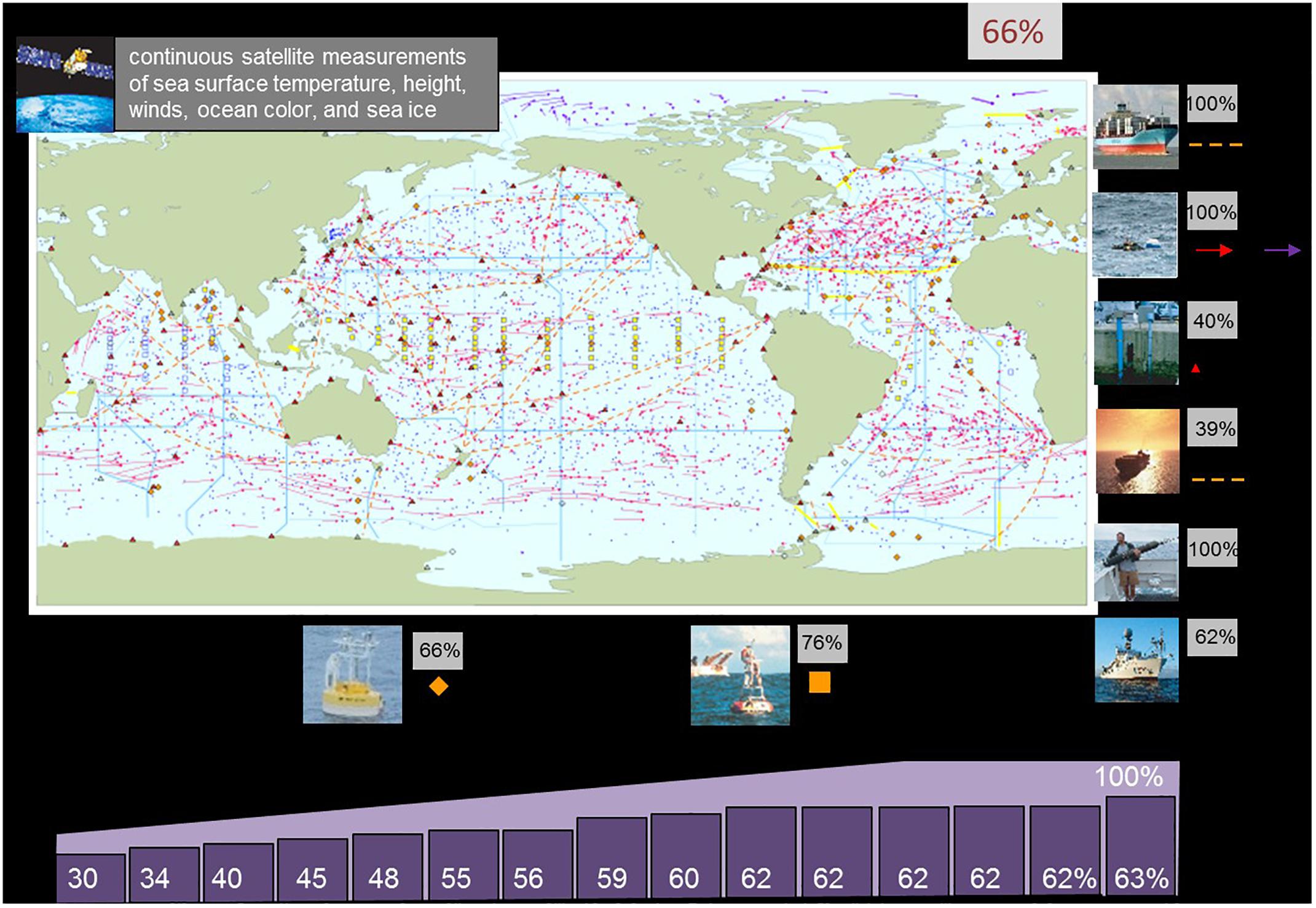
Figure 1. Implementation of GOOS in situ networks versus ‘design’ (IOC-UNESCO, 2018).
Recognizing that GOOS needed to address requirements beyond the ocean’s role in global climate, a key recommendation from OceanObs’09 was for international integration and coordination of interdisciplinary ocean observations. The OceanObs’09 sponsors commissioned a Task Team to respond to this challenge, leading to the development of A Framework for Ocean Observing, released in 2012 (Lindstrom et al., 2012).
The Framework for Ocean Observing applied a systems approach to sustained global ocean observing. It used Essential Ocean Variables (EOVs) as the common focus and defined the system based on requirements, observations, and data and information as the key components. Importantly it incorporated both coastal and open ocean observations. Assessment of feasibility, capacity, and impact for each of the three system components was based on readiness levels, i.e., concept, pilot, and mature.
It is the expansion of requirements for GOOS beyond weather and climate that is most significant in the context of this paper. Regional and global ocean assessments, fisheries management, ecosystem services, and real-time services have become drivers for GOOS over the last decade (Figure 2).
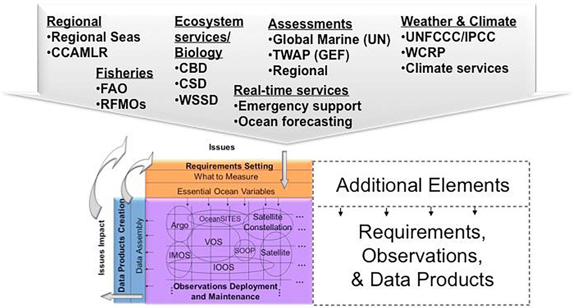
Figure 2. Framework for Ocean Observing, societal drivers for the next decade (Lindstrom et al., 2012).
Global Ocean Observing System now seeks to coordinate observations around the global ocean for three critical themes: climate, operational services, and marine ecosystem health (GOOS, 2018a). This has opened up a field of opportunity for new collaborations to be formed—across regions, communities, and technologies—facilitating much enhanced engagement in the global ocean observing enterprise.
The governance of GOOS needed to change in response to these expanded requirements; therefore, a three-tiered governance model was implemented. A multinational steering committee was established to provide oversight (tier one). Scientific expert panels were formed to guide system requirements. Pre-existing structures were evolved to create discipline-based panels, providing scientific oversight on physics, biogeochemistry, and biology/ecosystems (tier two). Efforts were also made to connect with observation coordination groups involved in implementation at global and regional scales (tier three): the Joint Technical Commission for Oceanography and Marine Meteorology (JCOMM), Observations Coordination Group (OCG), and the GOOS Regional Alliance (GRA) Council. The Chairs of JCOMM OCG and the GRA Council became ex-officio members of the GOOS Steering Committee. Finite lifetime observing system development projects (called GOOS pilot projects) were also introduced as a way of increasing the readiness of the observing system. Under this revised governance model, the GOOS Project Office has responsibility for facilitating collaboration between the three tiers.
In this paper we discuss progress in enhancing collaboration to meet the expanded requirements of GOOS in climate, operational services, and marine ecosystem health. Collaboration is considered among national systems, regional alliances, and global networks, in situ observing and remote sensing, and oceanography and meteorology.
The role of GRAs is considered in Section “Think Global, Act Local – Challenges and Opportunities in Collaborating Across GOOS Regional Alliances.” GRAs are particularly important for incorporating both coastal and open ocean observations, and for engaging with the users of operational services and the beneficiaries of marine ecosystem health. Efforts to build capacity within the GRA Council since OceanObs’09 are ongoing.
The need for GOOS to embrace new observations and data is considered in Section “The Need for New Observations and Biological and Coastal Data to Meet Expanded Requirements for GOOS.” The expanded requirements of GOOS in 2019 will not be met by a system designed in the 1990s. New EOVs for biogeochemistry (e.g., oxygen), and biology/ecosystems (e.g., zooplankton biomass and diversity, fish distribution, and abundance), need to be measured by platforms and sensors with the requisite level of technological readiness. Expanding spatial coverage of physical observing into coastal oceans requires additional technologies [e.g., high frequency (HF) radars, ocean gliders]. Global coordination of these additional networks presents a challenge for JCOMM OCG and others. That said, the fact that several GRAs are already operating some of these networks provides a basis for multinational coordination that can be leveraged. Partnerships with programs such as the Global Ocean Acidification Observing Network (GOA-ON) and other programs centered around EOVs rather than platforms provide another opportunity. The need for new data and information systems and products is also a significant issue.
The importance of harnessing national efforts is considered in Section “Harnessing the Power of National Capabilities and Multinational Collaborations.” Most investment in global ocean observing comes through national programs and to some extent has been engaged through the GRA Council and JCOMM OCG (e.g., in the United States, Australia, and Europe). In other cases, mature and emerging national programs have not yet been engaged in GOOS through existing intergovernmental mechanisms (e.g., in India, Canada, South Africa). In addition, multinational projects such as Tropical Pacific Observing System (TPOS) 2020 and AtlantOS are redesigning regional observing systems to enhance integration and fully leverage all available ocean observing technologies. How these redesigned systems are governed on an ongoing basis will be significant in a GRA context. Harnessing national efforts and regional collaborations is considered to be a major opportunity for GOOS in the coming decade.
In Section “GOOS as a Mechanism for Partnership Between Global Satellite and in situ Programs” considers the great expansion and advancement that is coming in both in situ and remote sensing ocean observation platforms [e.g., unmanned surface vehicles (USVs), new advanced satellites]. In combination, they provide the potential to measure new EOVs routinely at global scale. Enhanced collaboration between the in situ and remote sensing communities will deliver many benefits. Efficiencies will be gained through evaluation of requirements in an integrated manner. Effectiveness will be increased through development of blended products.
In Section “Integrating Marine and Ocean Observations Into the Global Observing System” considers the opportunities provided by the World Meteorological Organization (WMO) Integrated Global Observing System (WIGOS) in fostering a more comprehensive and integrated approach across meteorology and oceanography. Enhanced collaboration between these communities will allow end users to understand observational data more completely—and be assured that observations have been quality monitored and problems identified and fixed. Easier incorporation of partner networks and expansion of observations available will enable more comprehensive products to be generated for users. The focus of WIGOS is on provision of accurate, reliable and timely weather, climate, water and related environmental observations and products. This sits well with the expanded requirements of GOOS in climate, operational services, and marine ecosystem health.
In Section “The Way Ahead” outlines the way ahead. Significant effort has been expended by the GOOS community over the last decade in setting requirements, specifying EOVs, improving observations coordination, and reinvigorating GRAs. We argue that the focus now needs to shift to ensuring the ocean observing system clearly demonstrates and is widely recognized for its fundamental role in underpinning the delivery of climate services, weather predictions, regional and global ocean assessments, fisheries management, ecosystem services, and real-time services.
Think Global, Act Local – Challenges and Opportunities in Collaborating Across GOOS Regional Alliances
There has been a concerted effort over the past decade to reinvigorate the GRAs in response to challenges and opportunities identified at OceanObs’09, and through development of the Framework for Ocean Observing. Several initiatives have been undertaken to increase understanding and awareness, enhance collaboration, and build capacity. While good progress has been made, much more needs to be done in the coming decade if GRAs are to realize their potential in contributing to the vision and mission of GOOS.
What Are GRAs?
GOOS Regional Alliances identify, enable, and develop sustained GOOS ocean monitoring and services to meet regional and national priorities, aligning the global goals of GOOS with the need for services and products satisfying local requirements (IOC-UNESCO, 2013). Historically, the GRAs were introduced as a way to integrate national needs into a regional system and to deliver the benefits of GOOS strategy, structure, and programs at a regional and national level. The first GRA was formed in 1994, and the most recent addition was in 2014. There are now thirteen GRAs (see Table 1). For more information on the function and structure of the GRAs, please see the GOOS Regional Policy (IOC-UNESCO, 20131). All GRAs are focused on the provision of ocean observing information.
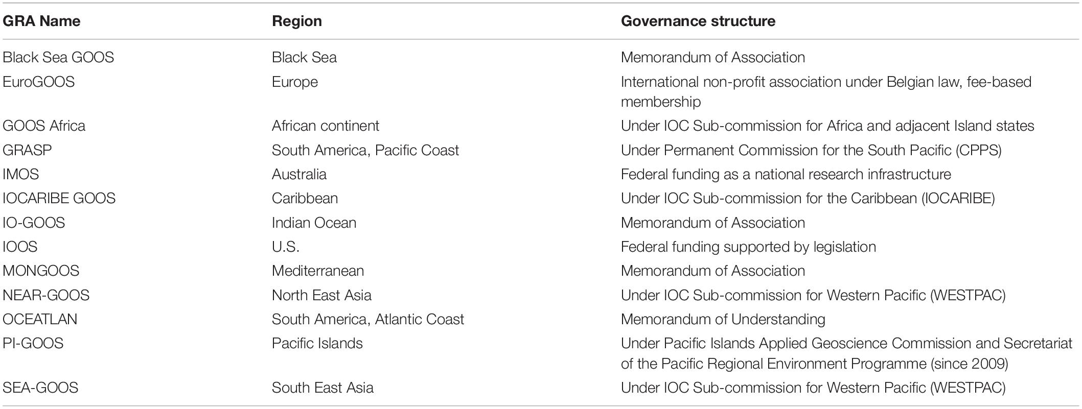
Table 1. Summary of GRA governance structures (GOOS, 2018b).
The leads of each GRA come together to form a GRA Council, which elects a Chair for a 2-year term, with a second term allowed. The Council can also elect a Deputy Chair to assist the Chair. A GOOS Regional Forum is held every 2 years, organized by the Chair with support from the GOOS Project Office. Between forum meetings, an action agenda is progressed through regular teleconferences. The GRA Council Chair is an ex officio member of the GOOS Steering Committee.
How the GRAs Are Governed
There is significant heterogeneity in the governance and funding of GRAs. Six GRAs are formed under IOC sub-commissions or related intergovernmental structures. Four are formed under memorandums of understanding. One is an international non-profit association, and two are funded national government programs.
Most GRAs can access funding only through ad hoc projects, if at all. Only U.S. Integrated Ocean Observing System (IOOS) and Integrated Marine Observing System (IMOS) have program budgets, with EuroGOOS having a member fee base.
Recent efforts across the GRAs have recognized this heterogeneity and taken a multifaceted approach to enhancing collaboration across regions, communities, and technologies. In this section we consider initiatives undertaken by the GRA Council to increase understanding and awareness, increase collaboration, and build capacity. As GOOS expands to include new observing networks (see section “The Need for New Observations and Biological and Coastal Data to Meet Expanded Requirements for GOOS”) and better embrace national and multinational capabilities (see section “Harnessing the Power of National Capabilities and Multinational Collaborations”), the potential contribution of a strengthened GRA network to the GOOS vision and mission is increasingly being recognized.
Consideration will need to be given as to whether the current GRA structure is fit for this purpose.
GRA Initiatives Since OceanObs’09
Since OceanObs’09, the better resourced GRAs have taken greater responsibility for leadership within the GRA Council. U.S. IOOS was elected Chair for 2012 and 2013, and again for 2014 and 2015 with IMOS as Deputy Chair. IMOS was elected Chair for 2016 and 2017, with EuroGOOS as Deputy Chair. EuroGOOS was elected Chair for 2018 and 2019, with IO-GOOS as Deputy Chair. The intention has been to create a forum where those who are responsible for implementing regional ocean observing systems have the chance to exchange ideas, develop best practices, and work closer together.
Assessments of GRAs
An important step was the completion of self-assessments by GRAs during 2012. These assessments included basic information on governance and management, societal benefit areas being addressed, types of observation technologies being operated, and data management arrangements. The assessments were summarized and discussed at GOOS Regional Forum VI in 2013, providing a basis for identifying priorities to increase collaboration and build capacity (Fischer and Willis, 2013).
The assessments dispelled the notion that GRAs supported only the coastal component of GOOS, highlighting that several GRAs had evolved to meet a wide range of societal challenges related to both the coastal and open ocean observations. They revealed that GRAs had been active in embracing new networks (see section “The Need for New Observations and Biological and Coastal Data to Meet Expanded Requirements for GOOS”), consistent with the expanded vision and mission of GOOS. Five GRAs were operating HF radar networks, seven were operating ocean gliders, five were operating animal tagging programs, and six were operating ocean acidification (OA) networks. The assessments also highlighted the operational modeling capacities within GRAs. The information provided in the assessments has been used to advance GRA activities since 2012.
With support from the GOOS Steering Committee (via the U.S. National Aeronautics and Space Administration [NASA]), an external review and analysis of all of the detailed inputs to the GRA assessments was then undertaken (GOOS, 2015). The review report was presented at the GOOS Regional Forum VII in 2015 and included a number of actions and recommendations for the GRA Council and the GOOS Project Office (GOOS, 2017). The full report is available online (IOC-UNESCO, 20152).
Mapping Ocean Observing Assets
Catalyzed by the assessment, a global inventory of ocean observing assets was established based on metadata and data supplied from GRAs. A key motivation was to encourage use of international metadata and data exchange standards across the GRAs consistent with the GOOS Regional Policy. The asset map includes most platform types and most ocean regions. It is updated periodically and maintained by the European Marine Observations and Data Network (EMODNet). The number of platforms displayed on the asset map has increased three-fold between the 2015 and 2017 GOOS Regional Forum meetings.
Development of an Ocean Modeling Inventory
In order to promote a value chain approach to ocean observing, the GRAs also compiled an inventory of operational ocean modeling activities. Information on the spatial extent and parameters output (state variables) of each model was provided using an internet-based mapping tool (EuroGOOS, 2018). GRAs can update this resource as new models for their region are developed providing useful guidance to users contemplating the use of such models.
GOOS Pilot Projects
The GOOS Steering Committee has identified focused, finite lifetime development projects (GOOS pilot projects) as an effective way to drive the development of the GOOS—both for redesigning mature observing systems and for expanding the observing system into new areas. The TPOS 2020 project was an early example. Initially it appeared that GOOS pilot projects would be selected by the Steering Committee or developed through the Expert Panels. At the GOOS Regional Forum VII in 2015, it was proposed that GRAs also develop and propose GOOS pilot projects (GOOS, 2017).
The GRA Council saw this as being a particularly important development. It is impossible to identify priorities benefiting all GRAs because of their significant heterogeneity. It is much more plausible for subsets of GRAs with different levels of capability and capacity to come together around issues of common interest. GOOS pilot projects provide a mechanism to do this.
During late 2015/early 2016 the first GRA pilot project was developed. MONGOOS and GOOS Africa (with support from U.S. IOOS and EuroGOOS) developed a MEditerranean Sea-level Change And Tsunamis (MESCAT) project. Its aims were to (a) create a tide gauge network covering all coasts of the Mediterranean Sea, (b) make sea level projections and impact studies in the Mediterranean Sea, and (c) develop capacity in North African nations to operate and maintain the network. The GRA Council also identified opportunities to develop similar multi-GRA pilot projects in the Caribbean and in the Pacific Islands.
The GOOS Steering Committee approved MESCAT as a GOOS pilot project in June 2016; however, it has yet to secure funding (GOOS, 2016).
Concluding Remarks and Recommendations
Notwithstanding progress over the last decade, significant heterogeneity in the governance and funding of GRAs continues to provide challenges.
Several GRAs are founded on governance agreements that do not easily allow the addition of new partners. Stakeholder feedback suggests that GOOS needs to become more inclusive of ocean observing efforts relevant to its expanded vision and mission, and more creative in facilitating expansion and growth. This is particularly the case for biological EOVs and for continental shelf and coastal marine systems, where societal benefit is highest.
Opportunities do exist to address this challenge. Taking advantage of the GOOS Steering Committee meeting held in Colombia in June 2018, a GOOS South American Regional Workshop was organized to discuss regional projects and national strategies on marine monitoring in this region (GOOS, 2018c). The workshop was acknowledged as an historic event that gathered key players and communities from across South America who share a common interest in realizing the vision and mission of GOOS, and whose plans are thus well aligned with the decadal strategy of GOOS. It highlighted the fact that significant capability exists within the region that is not currently engaged with the GRA structures. We must understand the impediments and work to remove them.
Scarcity of funding to support multinational ocean observing efforts and genuine capacity development within nations is also serious challenge. The GRA Council has shown it is capable of developing projects to address regional priorities and develop national capacity – projects that are worthy of endorsement by the GOOS Steering Committee. However, if there are no mechanisms to fund such projects, the contribution of some GRAs toward the vision and mission of GOOS will continue to be heavily constrained.
It is hoped that the United Nations Decade of Ocean Science for Sustainable Development will provide new opportunities to address this challenge.
The Need for New Observations and Biological and Coastal Data to Meet Expanded Requirements for GOOS
Global Ocean Observing System now seeks to coordinate observations around the global ocean for three critical themes: climate, operational services, and marine ecosystem health. To address these expanded requirements, new observations and data are clearly needed. This is especially true for the measurement of biological EOVs and for extending GOOS from the open ocean into continental shelf and coastal systems.
Bringing New Observing Technologies and Networks Into GOOS
The ocean observing networks currently recognized as being part of GOOS are shown in Figure 1 (see section “The Changing Context for GOOS – From OceanObs’09 to OceanObs’19”). There are other ocean observing networks in operation around the globe that can measure physical, biogeochemical, and biological EOVs across relevant time and space scales. GOOS needs to develop effective and efficient mechanisms to assess the readiness of new networks and facilitate their inclusion in the global system. These are not yet fully in place.
Here, the term “networks” refers to capabilities to observe the ocean and includes both collaborative frameworks of people as well as observing technologies and data management practices from national observing systems. They do not necessarily have a global design, like Argo or satellite virtual constellations. There are “global” networks where national/regional programs use common technologies to answer common questions and are coming together to share, learn, build capacity, and work to common data standards enabling interoperability where required.
As noted in Section “Think Global, Act Local – Challenges and Opportunities in Collaborating Across GOOS Regional Alliances,” multiple GRAs are operating HF radar networks, ocean gliders, animal tagging programs, and OA networks. The GRA Council has advocated for formal inclusion of these networks into GOOS. The adoption of other new technologies will continue as they are developed.
High Frequency Radar
The Global High Frequency Radar Network (GHFRN) was established in 2012 as part of the Group on Earth Observations (GEO) to promote HF radar technology. At that time there was no opportunity to integrate this activity in GOOS. HF radar networks produce hourly maps of ocean surface currents within 200 kilometers of a coastline. The technology is becoming a standard component of regional ocean observing systems, and the growth of the network remains steady with approximately 400 stations currently operating and collecting real-time surface current information. However, only 2% of the world’s coastline is currently measured with this technology. There are approximately 281 sites reporting to the GEO list as of 2018. Approximately 140 installations are active in the Asia-Pacific region, and this number is expected to grow with new installations in the Philippines and Vietnam. The number of organizations displaying surface current information on the GHFRN web page has also increased from seven in November 2016 to thirteen.
The GHFRN is aiming to standardize data formats across the regions, develop quality control standards and emerging applications of HF radar measurements, and accelerate the assimilation of the surface current measurements into ocean and ecosystem models. Participation in JCOMM OCG has been important in furthering these goals. The GRA Council has advocated for inclusion of HF radar as an observing element within GOOS and helped to facilitate development of a Network Specification Sheet for approval by the GOOS Steering Committee. However, this is yet to be achieved.
Ocean Gliders
Underwater ocean gliders and other autonomous surface vehicles serve as unique and versatile observation platforms. They can conduct sustained autonomous surface and subsurface ocean data collection in critical data-sparse areas that prove challenging for other observation platforms. As underwater glider operations at institutional and national levels have grown and matured, the benefits and opportunities of regional and international collaboration have been recognized.
Regionally, glider operators have come together to form user groups such as Everyone’s Glider Observatory (EGO) and the Underwater Glider User Group (UG2) to share best practices, improve operational reliability and data management, and work together to improve glider monitoring, ocean observing, and development of the glider platform. Internationally, the OceanGliders group has evolved from the above groups to serve this purpose. The OceanGliders group has formed task teams to focus international glider efforts in the priority areas of boundary currents, storms, water transformation, polar regions, and data management. The GRA Council is supporting these efforts, and the OceanGliders group is engaging with JCOMM OCG as an emerging network. It is expected that ocean gliders will eventually become recognized as an observing element within GOOS given their ability to collect physical and biogeochemical measurements at a range of scales.
Animal Tracking
The GOOS Biology and Ecosystems Panel was formed during 2013. By 2018, the panel had specified nine, new biological EOVs for GOOS. These include ‘fish abundance and distribution’ and ‘marine turtles, birds, mammal abundance and distribution.’ Animal tracking technologies (both acoustic and satellite) are widely used across the globe and can provide sustained observing of species distribution and abundance.
The Ocean Tracking Network (OTN) provides a global acoustic receiver infrastructure in all of the world’s five oceans3. With investment by the Canadian government matched through international partnerships and collaborations, OTN has deployed over 2,000 acoustic tracking stations (receivers) globally and tracks over 130 commercially, ecologically, and culturally valuable aquatic species.
Satellite tracking is being coordinated through the MEOP consortium, which stands for Marine Mammals Exploring the Oceans Pole to Pole4. MEOP brings together several national programs to produce a comprehensive quality-controlled database of oceanographic data obtained in polar regions from instrumented marine mammals. Over 500,000 vertical profiles of temperature and salinity have been collected since 2004 in the world ocean by attaching tags on marine mammals, such as Southern elephant seals. These data are complementary to those collected by Argo and it has been demonstrated that assimilating the temperature profiles into a global ocean forecast model has a positive impact in the predicted temperature and salinity in seal-sampled areas where other observational data are sparse (Carse et al., 2015).
Several GRAs, including U.S. IOOS, EuroGOOS, and IMOS, operate animal tracking programs and are working to support international animal tracking data standardization. The community is now engaged with JCOMM OCG as an emerging network under the title of ‘Animal-borne instrumentation.’
Global Ocean Acidification Observing Network (GOA-ON)
The GOA-ON5 is a collaborative international approach to document the status and progress of OA in open-ocean, coastal, and estuarine environments, to understand the drivers and impacts of OA on marine ecosystems, and to provide spatially and temporally resolved biogeochemical data necessary to optimize modeling for OA.
GOOS Regional Alliances with OA programs focus their OA activities through GOA-ON and the GOA-ON Data Explorer. The data explorer provides access and visualization to ocean acidification data and data synthesis products being collected around the world from a wide range of sources, including moorings, research cruises, and fixed time-series stations.
Global Ocean Acidification Observing Network attended the GOOS Regional Forum VIII in 2017 (GOOS, 2017). It is developing “GRA-like” regional networks, including OA-Africa, North American hub, Pacific Island hub, Arctic hub, WESTPAC, and Australia. Furthermore GOA-ON adheres to GOOS data principles, and the global data portal is built on the foundation of the U.S. IOOS data portal. Opportunities were identified for GRAs to assist GOA-ON in building its regional networks, and for GOA-ON to assist GRAs in bringing non-traditional partners into the GOOS enterprise.
Other Networks
Several other initiatives are underway to address gaps in global observing capability, and to find efficiencies in and opportunities for the integration of sustained biological observations. These include the GEO’ Marine Biodiversity Observation Network (MBON). MBON is prioritizing observations of marine life to address specific user needs, identifying and integrating those observations where feasible, addressing data management challenges to ensure broad accessibility of these data, and developing products that overlay biological observations with physical and biogeochemical observations to describe impact of ecosystem change on living communities. MBON funded partners and collaborators are actively supporting development of specification sheets and implementation plans for the full complement of GOOS Biology and Ecosystem variables.
Other cost-effective instruments have been developed and used in coastal ocean monitoring, e.g., FerryBox systems and shallow water Argo profiles (with oxygen and Chl-a measurements). For the purpose of environment assessment, a significant amount of chemical and biological observations are made in coastal waters and delivered offline, mostly not shared with the operational oceanography community. Further optimization of existing coastal observational networks and integration between different monitoring communities is needed.
Global agreement on EOVs has the additional benefit of providing a clear focus for existing networks to come together and integrate their methods and approaches to achieve a common goal. One example is the move toward “Globally consistent quantitative observations of planktonic ecosystems” being advocated by the Lombard and Boss et al Community White Paper. Observations of planktonic ecosystems are currently undertaken through discrete water samples, net tows, continuous plankton recorders (CPR), and satellite ocean color. Historically there has been limited integration across these methods. An EOV focus provides the opportunity to extract much greater value from the combination of these methods, particularly when coupled with biogeochemical and ecosystem modeling approaches.
Observations Coordination, and Data Assembly and Exchange
It is encouraging to see that JCOMM OCG has identified HF radar, ocean gliders and animal-borne instrumentation as emerging networks. These networks aspire to a global mission, and JCOMM OCG can provide advice and rigor in developing the policies, processes, and systems required to achieve this.
There will, however, be a limit to the scope of JOCMM OCG activities, which presently covers networks that measure physical and bio-geochemical EOVs. For example, the GOOS Biology and Ecosystems Panel has specified new biological EOVs covering hard corals, seagrasses, macroalgae, and mangroves. It is difficult to see how observations coordination for the global networks required to measure these EOVs could be done more effectively through JCOMM OCG.
Additional, complementary observations coordination mechanisms will be required, though care needs to be taken in avoiding network-specific approaches that fail to realize the benefits of an integrated, biophysical observing system. A clear focus on outcomes and societal benefit will be the key. To use but one example, measuring hard coral cover as an EOV will be enormously valuable. Providing the tools to monitor and manage coral bleaching, however, will require the integration of satellite sea surface temperature (SST) and in situ sampling technologies, as well as numerical modeling and forecasting.
Related to the above, new observing technologies and networks aspiring to become part of GOOS must develop robust and sustainable mechanisms for data assembly and exchange. It is significant that the HF radar, ocean gliders, and animal-borne instrumentation ‘emerging networks’ are all working on data standardization within their communities. This should be strongly encouraged and supported.
The JCOMM Open Access Global Telecommunication System (GTS) pilot project is an exciting development that has potential to greatly enhance oceanographic data assembly and exchange. On one hand, the rigor and robustness of the WMO GTS sets a standard for which the oceanographic community can aim. On the other hand, many in the oceanographic community currently find it difficult to get data into and out of the GTS, limiting its broader utility. The Open Access GTS pilot project aims to retrieve newly inserted data from the GTS, decode it from the WMO Binary Universal Form for the Representation of meteorological data (BUFR) format, add the data and metadata to a database, and provide access via web-accessible tools and visualizations.
Expansion of GOOS to encompass biological EOVs and continental shelf and coastal marine systems presents some distinctive challenges in terms of data access, assembly, and exchange. The Ocean Biogeographic Information System (OBIS) is working with the GOOS Biology and Ecosystems Panel on these challenges. OBIS aims to provide a global, open-access data and information clearinghouse on marine biodiversity for science, conservation, and sustainable development.
Concluding Remarks and Recommendations
In the next decade, inclusion of more physical-biogeochemical observing systems such as HF radar, ocean gliders, animal tagging and tracking, Ferry Box and shallow water profiling Argo floats should be considered and realized as observing elements within GOOS. Better coordination among various systems, such as the GOA-ON and MBON should be facilitated by GOOS. Observations coordination and data assembly/exchange will be essential to realizing the opportunities provided by new collaborations across regions, communities, and technologies.
Harnessing the Power of National Capabilities and Multinational Collaborations
Most investment in global ocean observing comes through nation-states. This manifests through cooperative investment by multiple nations in international programs and through investment in national programs with broader reach. International programs such as Argo and satellite virtual constellations have traditionally been the focus of GOOS. Here we focus on investments in national programs with broader reach, to better harness the power of national capabilities and multilateral collaborations.
Consideration is given to national programs already engaged as GRAs, in the United States, Australia, and Europe. In other cases, investments are being made into national programs that are not currently aligned with GRAs in India, South Africa, Canada, and South America. In addition, recent multinational projects such as the TPOS 2020 and AtlantOS are stimulating discussion about governance of basin-wide ocean observing systems into the future.
National Capabilities and Regional Alliances
Since OceanObs’09, the GRA Council and GOOS Steering Committee have increasingly recognized the value of engaging with strong national programs that meet the requirements of the GOOS Regional Policy (IOC-UNESCO, 2013).
Current GRAs
As Chair of the GRA Council from 2012 to 15, the leadership demonstrated by U.S. IOOS has been crucial in reinvigoration of the GRAs. U.S. IOOS has partnered with nations in adjacent waters, invested in new technologies and networks (and supported them in contributing to a global mission), and embraced international data standardization. It has shown how a national program can operate as a regional alliance to support the vision and mission of GOOS.
Australia’s Integrated Marine Observing System (IMOS) is the newest GRA. IMOS was established in 2007 and has benefited greatly from the thinking that emerged from OceanObs’09 and through development of the Framework for Ocean Observing. IMOS was recognized as a GRA in 2014.
EuroGOOS is the European component of GOOS. It brings together 42 member-institutions and five regional ocean observing systems within Europe. EuroGOOS works closely with MONGOOS (in the Mediterranean) and Black Sea GOOS. A community-driven coordinating framework for Europe’s ocean observing capacity is currently under development. The European Ocean Observing System (EOOS) will link the disparate components of the ocean observing system and promote shared strategies, infrastructure development, data standardization, open access, and capacity building.
Opportunities to Strengthen the GRAs
As noted in Section “Think Global, Act Local – Challenges and Opportunities in Collaborating Across GOOS Regional Alliances,” the GRAs are not homogeneous in their makeup. In some cases, mature ocean observing networks exist within IOC member countries that are not yet part of the GOOS enterprise.
India
India plays a major role in IO-GOOS, a GRA focused at basin scale in the Indian Ocean. India, however, also has a very mature national Ocean Observing Network (OON), operating Argo floats, XBTs, current meters, wave rider buoys, tsunami buoys, tide gauges, ship-based weather stations, and a mooring network. The collective ocean observing capability of the Indian National Centre for Ocean Information Services (INCOIS), National Institute of Ocean Technology (NIOT), Earth System Science Organization (ESSO), and related organizations is globally significant. A presentation on India’s OON was delivered at the GOOS Regional Forum VIII in 2017, and IO- GOOS is now Deputy Chair of the GRA Council. These are small but hopefully significant steps in better engaging India’s national capability in the GOOS enterprise.
South Africa
Global Ocean Observing System Africa is a GRA that has a massive amount of ocean to observe, yet it is currently unfunded. Considering the oceans around the African continent at regional level, so as to take advantage of national strengths, may be one way to move forward. The South African Environmental Observation Network (SAEON) covers both terrestrial and marine environments. It includes a marine-offshore systems (Egagasini) node and a coastal (Elwandle) node. The Sentinel coastal site for long-term ecological research consists of 100 in situ instruments collecting data (mostly delayed mode) continuously since 2008. Including SAEON as a GRA would encourage government support, technical support from other GRAs, setting of requirements and standards, support for the measurement of EOVs, and access to calibration facilities.
North America
Within North America, only U.S. IOOS is formally part of the GRA Council. Canada has significant capability in ocean observing, through programs such as the OTN, Ocean Networks Canada (ONC) and MEOPAR. Canada has embarked on a process to establish a Canadian IOOS, and they are planning to cooperate with U.S. IOOS as part of a larger North America GRA.
Mexico currently does not have a government-wide ocean observing system but has been developing its ocean observing capacity through the Consortium of Institutions for Marine Research (CIIMAR). CIIMAR and the U.S. IOOS’s Gulf of Mexico Regional Association have signed a memorandum of understanding and exchange expertise in data management.
South America
In South America there are three GRAs, which represent joint efforts of countries and institutions to integrate national needs into regional systems. The GRAs aim to develop and implement operational ocean monitoring systems based on data sharing and enhancing capacity development. In this region, representation on the GRA Council has generally been through naval institutions. There are, however, several mature programs/projects operating in South America at the subnational, national, or regional level that could strengthen and expand the ocean observing capabilities in the region and be integrated into GOOS. The recent GOOS South American Regional Workshop (see section “Concluding Remarks and Recommendations”) recommended that regional IOC structures (the GRAs) be revitalized to incorporate a larger multidisciplinary observing community and to improve their communication to all stakeholders, capitalizing on opportunities (Miloslavich et al., 2018).
Two of the thirteen GRAs operate in the East Asian Region i.e., NEAR GOOS and SEAGOOS. Both operate under the auspices of the IOC Sub-Commission for Western Pacific (WESTPAC). Given the dynamic nature of ocean-based economic development in this region, and the importance of ocean observing to inform this development, opportunities are arising to significantly increase the role of East Asian countries in the GOOS enterprise. The TPOS 2020 project provides one example. The involvement of China, as well as South Korea, is emerging as fundamental to successful implementation of the TPOS 2020 vision.
Alliances of the Future
AtlantOS
In May 2013, the European Union (EU), Canada, and the United States signed the Galway Statement on the Atlantic Ocean Cooperation, with the stated goal of “advancing a shared vision on an Atlantic Ocean that is healthy, resilient, safe, productive, understood and treasured so as to promote the well-being, prosperity, and security of present and future generations” (Geoghegan-Quinn et al., 2013). AtlantOS has the goal of transitioning a loosely coordinated set of existing ocean-observing activities into a fit-for-purpose Integrated Atlantic Ocean Observing System (IAOOS). AtlantOS will conclude in 2019, and while there have been good discussions on a design and framework of an IAOOS, a funded, sustained system is not a result of this effort. There has been a concern that AtlantOS was too focused on the North Atlantic, which resulted in the Belem Statement being signed in July 2017 to strengthen the successful partnership with the European Commission and the Department of Science and Technology of Brazil and South Africa (Moedas et al., 2017). While this agreement has not directly resulted in a funded project, it has set up another convening forum to discuss issues in the southern Atlantic.
TPOS 2020
The TPOS 2020 Project will evaluate, and where necessary change, all elements that contribute to the current configuration of TPOS based on a modern understanding of tropical Pacific science (Legler and Hill, 2014). It is a focused, finite term project established in 2014 in response to deterioration of the tropical moored buoy array in the Pacific in 2012–2014. While TPOS 2020 provides an opportunity to evaluate new technologies to enhance and redesign the observing system in this important region, its ongoing governance is yet to be worked out. A TPOS Resources Forum has been established to consider the issues of long-term funding and governance.
The Southern Ocean Observing System (SOOS)
Southern Ocean Observing System is an international initiative of the Scientific Committee on Antarctic Research and the Scientific Committee on Oceanic Research (SCOR) (Rintoul et al., 2010). SOOS was officially launched in 2011. In the Antarctic region, scientific activities are guided by international treaties and organizations outside the IOC system. Furthermore, the SOOS project office has limited funding and needs to focus its efforts on the highest priorities. For these reasons, SOOS participation in the GRA Council has not yet been realized.
Group on Earth Observation
The GEO is an intergovernmental organization working to improve the availability, access and use of earth observations. GEO is structured with Flagships, Initiatives, Community activities, and foundational tasks. There are two efforts within GEO where the ocean community participates. First, as part of the GEO Biodiversity Network (GEOBON), the United States funding of MBON projects introduced a marine component to the GEOBON. MBON is working on a pole-to-pole effort under the AmeriGEO regional effort of GEO. Through GEO’s Blue Planet initiative, the ocean community representing the observing, data management and modeling community come together to advance and exploit synergies among the many observational programs devoted to ocean and coastal waters and, in particular, raise awareness of the societal benefits of ocean observations at the public and policy levels. For Blue Planet, the United States has resourced an Executive Secretariat and Australia funds the website. Support is also received from POGO and the European Union. The initiative is organized through six working groups, two projects consisting of (1) an early warning system for reef-lined islands and (2) a multi-hazard information and alert system for the wider Caribbean, and two nodes – MBON and water quality.
Concluding Remarks and Recommendations
There are several issues to consider if we are to harness fully the power of national capabilities and multinational collaborations within the GOOS. The benefits of being part of GOOS need to be much more apparent to countries, institutions, and programs. GOOS needs to become more inclusive, with effective and efficient mechanisms to facilitate new partners and partnerships.
Global Ocean Observing System is part of the United Nations system with representation from individual countries. The GEO is an intergovernmental voluntary organization that operates through member nations and participating organizations with a focus of the use of earth observations (air, land, and sea) within the policy arena. What both organizations share is the fact that implementation is based on national contributions and efforts. They are both convening bodies, and alignment with them can help bolster national efforts. Further, neither GOOS nor GEO are funding bodies in their own right, but nations, and in particular the European Union, use both of these organizations as mandates for their annual funding calls. GEO has evolved to align its work program through flagships, initiatives, community activities, and foundational tasks, all of which are articulated through plans that span 2 years. It is recommended that an implementation planning approach be adopted by GOOS in moving forward, providing clearer pathways for engagement.
While GOOS has evolved within the last 10 years and has begun to have a more inclusive focus, partnering is an area in which there must be continued focus. In advocating for emerging networks 600 and pilot projects, the GRA Council found that GOOS processes were either unclear or did not yet exist. GOOS should continue to strongly endorse new partners and partnerships, which will in turn help the national efforts to sustain funding.
The challenge of sustained funding must be addressed, where sustained funding is sometimes equated with transition from research to operational systems. In reality, there are few examples of research to operational transitions resulting in sustained funding. Here we suggest an alternative nomenclature of sustained and experimental observations, providing an overall roadmap that connects the various observing efforts, along with a community-wide consistent message on the importance of ocean observing.
U.S. IOOS has long-term funding within the U.S. government and is considered an operational ocean observing system that supports research. The U.S. contribution to Argo is within the research arm of the National Oceanic and Atmospheric Administration (NOAA) and has long-term funding in support of operational forecasting. Within Australia, IMOS was established as a research infrastructure, but through long-term funding and open data access, it has been able to support both research and operational needs. Within Europe there has been a recognition that, while ocean observing data and information are required to meet many societal challenges—from food security, to climate change, ecosystem health, or water management—the European in situ ocean observing capacity is still fragmented and broadly not sustained. While the space-borne ocean observations are funded through the Copernicus program, most in situ observations are supported through short-term projects, with no guarantee of a long-term sustainability. Europe has embarked on establishing the EOOS in order to address this dichotomy.
Recommendations:
(1) Resources are finite and the community cannot be balkanized. A robust dialogue is encouraged on how GOOS wants to organize the contributions by its members. Specifically, while the GRAs have shown progress, challenges remain. There has been the emergence of basin scale efforts. How can these two structures be complementary? Is there a hybrid organization that should emerge?
(2) The GOOS Regional Council has been active in the last 10 years but has never been endorsed by the IOC. Pending the discussion on the overall organization, the recognition by IOC of the GOOS Regional Council can help strengthen the foundation of the GRAs.
(3) GOOS should assess and develop a prospectus on the benefits of participating within a GRA to entice increased membership by national programs.
(4) GOOS should adopt a more inclusive approach to new networks and be a welcoming system to emerging technologies. Clear criteria and processes for inclusion should be written and adopted.
(5) GOOS and GEO are both convening authorities that by themselves do not have resources for the implementation of the observing systems. GOOS and GEO do appeal to different leaders and funding sources. These organizations should find ways to support each other and remove perception that these are competing efforts.
(6) GOOS should find new ways to work with GEO to make the compelling case that ocean observations are critical to policies and economic prosperity.
(7) GEO’s new Secretariat Director has stated that GEO should take the lead in providing curated in situ observations; GOOS should lead the effort for ocean observations.
(8) It is recommended that GOOS adopt the following nomenclature to help advance discussion of sustained funding:
• Sustained observations: measurements taken routinely that are committed to monitoring on an ongoing basis. These measurements can be for public services or for Earth-system research in the public interest.
• Experimental observations: measurements (taken for a limited observing period) that are committed to monitoring for research and development purposes. These measurements serve to advance human knowledge, explore technical innovation, improve services, and in many cases, may be first-of-their-kind.
In this way nations could continue to seek different types of funding sources as appropriate and be recognized as observations that need to be sustained over a long period. This can also be helpful in communicating a consistent message to prospective funding agencies.
GOOS as a Mechanism for Partnership Between Global Satellite and In Situ Programs
In the past decade, ocean observations have made great strides in expanding EOVs from in situ, satellite and other remote sensing platforms, as well as in improving accuracy and spatial-temporal resolutions and coverage. In part, the ocean observing system design, implementation, and product generation are guided by the integration of satellite and in situ observations for maximizing benefits and minimizing costs. This section reviews the progress made in those areas and envisions future improvements in anticipation of new capabilities.
Satellite Oceanographic Observations and Product Development and Services
Earth-observing satellites have been operated by individual countries for their national needs and 663 priorities. International collaborations have also been forged, driven by both scientific/application 664 needs and cost constraints. The constellation of satellites launched jointly and/or separately by different countries have recently shown added value to resolve finer and shorter time scale variability of the ocean and atmosphere when data from multiple satellites flying concurrently are merged together. This highlights the importance of international coordination to ensure the continuation of the constellation of Earth-observing satellites, and the consistent quality control and timely open access of the data. As an example, the operational polar-orbiting satellites operated by several countries are sketched in Figure 3 for two decades spanning the OceanObs’19. Here the data are mined from the WMO Observing System Capability Analysis and Review Tool [OSCAR], discussed in Section “Data Exchange Under WIGOS,” as of Oct 15, 20186.
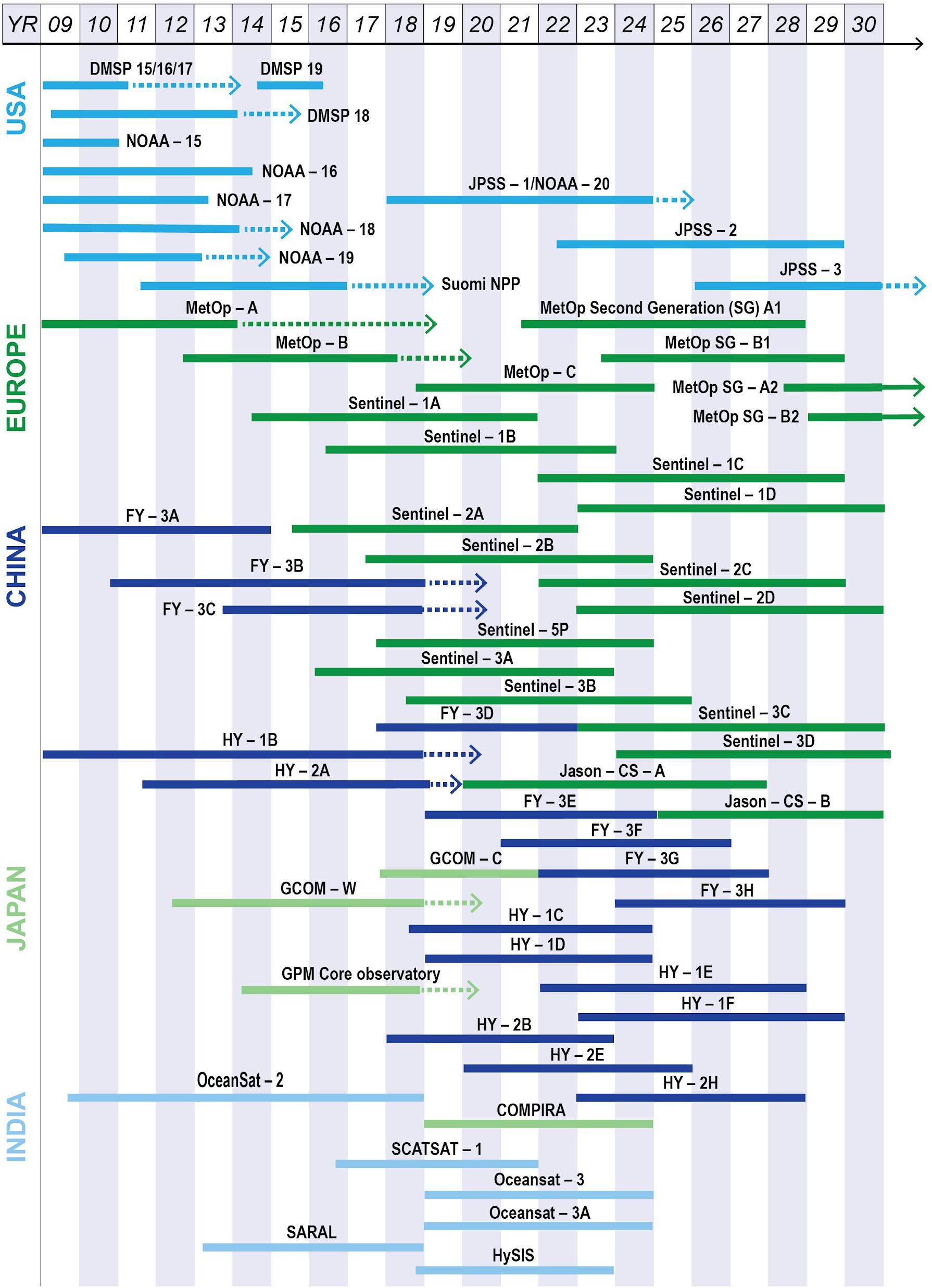
Figure 3. A schematic sketch of major operational polar-orbiting satellites, showing the wealth of data from which blended products can be generated in response to increased needs on spatial-temporal resolutions and accuracy for research and societal applications.
As the satellite technology advances, more advanced sensors for more essential ocean and atmospheric variables are added. For example, the new NOAA Joint Polar Satellite System (that includes the EUMETSAT Metop) satellites are equipped with advanced sensors and include: (1) the Advanced Technology Microwave Sounder (ATMS, for measuring moisture and temperature); (2) the Cross-track Infrared Sounder (CrIS, for monitoring moisture and pressure); (3) the Ozone Mapping and Profiler Suite (OMPS, for measuring ozone levels; (4) the Visible Infrared Imaging Radiometer Suite (VIIRS, for observing weather, climate, oceans, nightlight, wildfires, ice movement, and changes in vegetation and landforms); and (5) the Clouds and the Earth’s Radiant Energy System (CERES).
In addition to the world’s operational weather and ocean satellites, some space agencies also operate research-oriented, Earth-observing satellites. For example, NASA (U.S.) has been running various research Earth Observing System (EOS) satellites since the 1980s. Many of these satellites are joint missions with NOAA and other international partners like European Space Agency (ESA), such as the Jason altimeter satellites. These satellites measure essential climate and Earth environmental variables such as radiation, clouds, water vapor, and precipitation, the oceans states, greenhouse gases, land-surface hydrology and ecosystem processes, glaciers, sea ice, and ice sheets, ozone and stratospheric chemistry, and natural and anthropogenic aerosols7. Some near-future missions include the Surface Water Ocean Topography mission to make a global survey of Earth’s surface water, giving scientists the first comprehensive view of Earth’s freshwater bodies from space and much more detailed measurements of the ocean surface than ever before.
Complementary to polar-orbiting satellites, Geostationary Operational Environmental Satellites (GOES) provide more continuous monitoring of the Earth’s environment, ensuring a constant surveillance for severe weather conditions (e.g., tornadoes, flash-floods, hail storms, and hurricanes). Started in 1975, the latest U.S. GOES generation is the GOES-R series with more advanced sensors on four satellites planned: GOES-R/GOES-16 launched in 2016; GOES-S/GOES-17 launched in 2017; GOES-T planned for 2020; and GOES-U planned for 2024. In addition EUMETSAT operates the Meteosat satellites: Meteosat-8, -9, -10 and -11 that operate over Europe, Africa and the Indian Ocean.
In Europe, a systematically coordinated Earth-observing and monitoring program called Copernicus is managed by the European Commission and consists of two major components: the space component performed by the European Space Agency (ESA), and the in situ component performed by the European Environment Agency and EU countries. The space component consists of two groups of satellites: the Copernicus dedicated satellites (the six “Sentinels Satellites”) and the Contributing Missions, roughly thirty satellite missions that are operated by national, European, or international organizations. EUMETSAT is responsible for operating the Sentinel-3 satellites, with ESA support, and delivering the marine data and will also operate and deliver products from the Sentinel-4, and Sentinel-5 instruments, and the Sentinel-6 satellites.
In Asia, the Japan Aerospace Exploration Agency (JAXA) manages the Japanese Earth Observation Satellites, including the current Global Change Observation Mission-Climate/Water (GCOM-C, GCOM-W), the Global Satellite Mapping of Precipitation (GSMaP), and AMSR-E. The Indian Space Research Organization operates Indian’s Earth Observation Satellites, include OceanSat-1/2 and SCATSAT (provide wind vector data products for weather forecasting, cyclone detection and tracking services to the users), INSAT-3D/3DR, the Satellite with ARGOS and ALTIKA (SARAL, a joint Indo-French satellite mission for ocean surface altimetry measurements). In China, the Chinese Meteorological Agency (CMA) operates the weather satellites, the Fengyun series, and the Chinese State Oceanic Administration (SOA) operates oceanographic satellites, the Haiyang series. In 2018, China-France Oceanography Satellite (CFOSAT) will be launched to study ocean surface winds and waves.
In situ Oceanographic Observations and Product Development and Service
In addition to coordinated regional observing systems such as the GRAs discussed earlier, internationally, the WMO/IOC JCOMM serves as a focal point for coordinating worldwide in situ observations and data management. A snapshot of the worldwide observing system monitored by the JCOMM in situ Observations Programme Support Centre (JCOMMOPS) is shown in Figure 4.
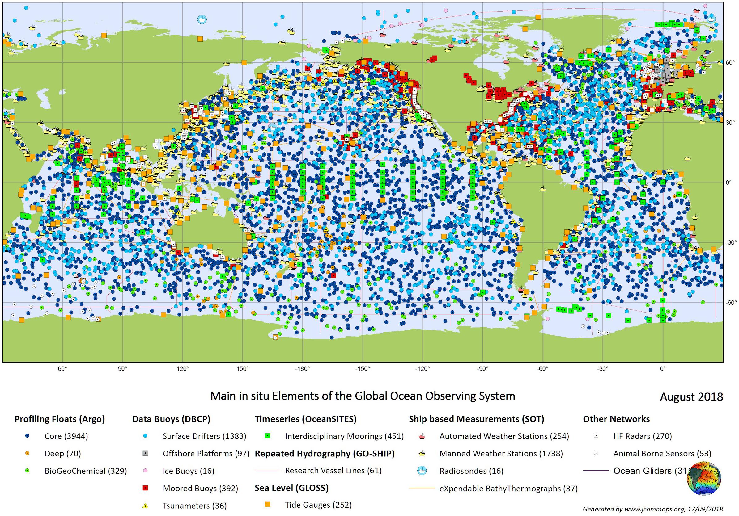
Figure 4. A snapshot of global ocean observations generated by JCOMMOPS (JCOMM, 2018).
Major ocean surface observing platforms include ships, moored and drifting buoys, Argo floats, and gliders. Their data are used for ocean and weather forecasts, climate research, and monitoring/societal applications. Data from many of these observing systems, such as the moored buoys from the TAO/TRITON, RAMA, PIRATA, OceanSITES, various national and coastal buoy networks, ship data from SOOP/VOS/VOSclim, and Argo, are also reported in near-real-time to operational forecast centers via the WMO GTS.
Ships have the longest history of observations, starting in 1662 and collected in the International Comprehensive Ocean-Atmosphere Data Set (Freeman et al., 2017). Surface drifting buoys became abundant in the late 1970s (Freeman et al., 2017) and sustained with a global requirement (Zhang et al., 2009). Argo floats became abundant in the 1990s delivering measurements of temperature and salinity made during vertical profiles together with measurements along the floats subsurface drift trajectories. Although Argo floats originally focused on temperature and salinity, inclusion of other parameters, such as biogeochemical variables, had been called for and coordinated at the OceanObs’09 (Claustre et al., 2009; Gruber et al., 2010). Biogeochemical (BGC)-Argo floats with additional sensors for oxygen, pH, nitrate, chlorophyll, backscatter, and irradiance have been increasing since then with international participations8. The Southern Ocean Carbon and Climate Observations and Monitoring project has demonstrated successful application of BGC-Argo floats at a basin-scale and has been responsible for much of the recent expansion of biogeochemical profile data. As of October 8, 2018, there are 10,413 O2 profiles obtained by 313 sensors/floats, 3,692 NO3 profiles by 135 sensors, 2,481 pH profiles by 104 sensors, 7,244 Chl-a and suspended particles by 209 sensors, and 2,949 downwelling irradiance profiles by 60 sensors.
New technologies and unmanned surface vehicles (USVs) are being integrated into ocean observing systems. Among the most recent additions to the GTS are data from the Saildrone USV. The NOAA- Saildrone partnership has conducted four missions in the Arctic region, two missions for the Tropical Pacific Observing System (TPOS), one fisheries survey mission on the west coast of North America, and test missions in the Southern Ocean. The Saildrone platform is a truly integrated system, equipped with a suite of sensors measuring meteorological, oceanographic, physical, and biogeochemical variables. In addition, a number of commercially available USVs have been developed and these are increasingly being used by the research community and industry, e.g. the Wave Glider, AutoNaut and Sailbuoy, and are all capable of carrying meteorological and oceanographic sensors and contributing to GOOS.
Community and International Collaborations
As Earth’s climate and environmental conditions are without national boundaries, international coordination is intrinsically needed to be successful. In fact, at the very beginning of the U.S. weather satellite missions, Dr. Harry Wexler, the key person in developing the TIROS satellites, had proposed and promoted the idea of a World Weather Watch (WWW) from 1959, and served as the lead negotiator for the U.S. in talks with the U.S.S.R. concerning the joint use of meteorological satellites. Now, under the Committee on Earth Observation Satellites (CEOS, established in 1984), the current 60 participating agencies operate 156 satellites including ocean observing satellites. CEOS is the mechanism that brings these organizations together to collaborate on missions, data systems, and global initiatives that benefit society as a whole, while aligning with their own national and agency missions and priorities. On the in situ observations, the WMO/IOC JCOMM is a key organization in coordinating international marine observations. Closer collaboration between CEOS, JCOMM and GOOS needs to be forged.
Blended Satellite and in situ Products and Services
Application needs for ocean and weather forecasts, scientific research and assessments, and societal applications require increasingly higher spatio-temporal resolution, accuracy and coverage. However, observations by each individual system have limitations, thus products generated by blending multi- resource observations have been needed and produced. Product resolutions are constrained by available observational data, as shown in the sampling study of Zhang et al. (2006) for multi-satellite blended sea winds (Zhang et al., 2006). Also, bias correction is a key step in generating blended products: as a case for integrating satellite and in situ ocean observations for SST, Zhang et al. (2009) simulated required in situ data density to reduce satellite SST biases to a sufficiently small level (Zhang et al., 2009).
Bias corrections are needed not only between satellite and in situ observations (Reynolds et al., 2002) but also between in situ observations themselves (Smith et al., 2008; Huang et al., 2017; Huang et al. (2018) or between satellite observations themselves (Yang et al., 2016). In Huang et al. (2017), a systematic ship-buoy SST offset of about 0.12°C was found and corrected before merging the ship-buoy SSTs into a gridded dataset. Similarly, a systematic Argo float SST and buoy SST offset of about −0.03°C was found and corrected, and in Huang et al. (2018), the relative roles of Argo floats and moored/surface drifting buoys are analyzed.
Various groups have established databases for quality monitoring of in situ and satellite data and blended products [e.g., NOAA’s in situ SST quality monitor (iQuam); Xu and Ignatov, 2014 and SST quality monitor (sQuam; Dash et al., 2010)]. The Group for High Resolution Sea Surface Temperature (GHRSST) is an open international science group that promotes the application of satellites for monitoring sea surface temperature (SST) by enabling SST data producers, users and scientists to collaborate within an agreed framework of best practice. GHRSST provides a framework for SST data sharing, best practices for data processing and a forum for scientific dialogue. Data from multiple sources are used to generate the GHRSST Multi-product Ensemble (GMPE) SST analysis (Martin et al., 2012). POES and GOES blended SSTs are produced at NOAA (Maturi, 2010).
National oceanic and atmospheric administration’s Coast Watch and Ocean Watch program collects and serves satellite observational data (sea surface temperature, sea surface height, sea surface salinity, sea surface winds, and sea surface ocean color), together with in situ data quality monitoring.
For biogeochemical variables, Amin et al. (2015) assessed GOES satellite-based ocean color products using in situ networks (Amin et al., 2015). Land et al. (2018) used a database of satellite in situ matchups to generate a statistical model of satellite uncertainty as a function of its contributing variables for ocean color chlorophyll-a and showed that most errors are correctable biases (Land et al., 2018). Martínez-Vicente et al. (2017) examined the differences among phytoplankton carbon (Cphy) estimations from six satellite ocean color algorithms by comparison with in situ estimates, and large (>100%) biases have been found (Martínez-Vicente et al., 2017). Under the European’s Copernicus Ocean Colour Climate Change Initiative (OC-CCL), chlorophyll product was compared to the Copernicus Marine Environment Monitoring Service products and GlobColour reanalysis products. Ocean carbon examples include the validation of NASA Orbiting Carbon Observatory satellite data by in situ, moored CO2 observations (Chatterjee et al., 2017) and creation of surface seawater pCO2 and CO2 flux maps from observation-based algorithms applied to satellite SST and color (Feely et al., 2006; Landschützer et al., 2016).
Concluding Remarks and Recommendations
Looking to the next decade, we foresee great expansion and advancement in both in situ and remote sensing ocean observation platforms, with the expansion of EOVs (e.g., biogeochemical variables observed routinely). Blended products can be improved through consideration of the new and improved satellite and in situ systems. This whitepaper invites the in situ and remote sensing observation communities to work more closely to suggest approaches for improvements of the ocean observing system and EOV products through an integrated, multi-platform perspective. Specifically:
Recommendation: GOOS should serve as an agent to strengthen the ties between oceanographic space and in situ observation systems to maximize benefits and minimize cost.
Recommendation: In coordination with WMO/IOC JCOMM, CEOS and others, GOOS should pay particular attention to development and improvement of EOV-based products that integrate across various ocean-observing systems. Additional needs include historically consistent data records for monitoring and assessing environmental changes, and extending physical climate data records to biogeochemical and ecosystem variables.
Integrating Marine and Ocean Observations Into the Global Observing System
As noted earlier in this paper, GOOS collects essential data for monitoring and improving understanding of our oceans and climate to provide operational services (prediction of ocean-related hazards such as tsunamis, storm surges, and high waves) and in the last decade has expanded into marine ecosystem services. In particular GOOS data are essential for weather forecasts that are critical for the safety of life at sea (severe weather and waves) and coastal protection (storm surges and wave overtopping), and climate change services that support adaptation and mitigation policies. WMO is one of the sponsors of GOOS, and its members, through many of their National Meteorological and Hydrological Services (NMHS), provide observations for GOOS (primarily from ships and buoys) and are users of GOOS data. Virtually all products and services generated by NMHS rely on data from across various domains: land, sea, and air, whether measured in situ or remotely sensed (e.g., from space). This has led to the WMO Global Observing System (GOS) of the WWW Programme, which has over the years developed in an incremental way and is now evolving into the WIGOS.
WIGOS – The WMO Integrated Global Observing System
In 2013 the Implementation Plan for the Evolution of Global Observing Systems (EGOS-IP) was published. EGOS-IP set out the plan for developing the WMO Global Observing Systems covering the period 2012–2025 and their role within the collective WMO Integrated Global Observing System (WIGOS) “system of systems” (WMO, 2013). WIGOS provides a framework for all the WMO-sponsored and co-sponsored observing systems, encompassing both in situ and remotely sensed observations—within which GOOS is an important component. The implementation of WIGOS is one of seven strategic priorities of the WMO and aims to foster the evolution of its observing systems, many of which have evolved independently, into a more comprehensive and integrated system. This will provide a more consistent system for the delivery of weather, climate, water, and related environmental observations and products generated by WMO members and programs and make major contributions to the Global Earth Observation System of Systems (GEOSS). Further information on WIGOS is available in the Guide to WIGOS (WMO, 2017). However, it is important to recognize that WIGOS is about much more than simply integrating observing networks, as it includes system/network design, planning and evolution; system operation and maintenance; data quality monitoring and management; standardization, interoperability and data compatibility; discovery and availability of data and metadata; capacity development; communications and outreach – all of which are appropriate to GOOS.
The component observing systems of WIGOS are: (a) the GOS of the WWW Programme, (b) the observing component of the Global Atmosphere Watch Programme, (c) the WMO Hydrological Observing System of the Hydrology and Water Resources Programme, and (d) the observing component of the Global Cryosphere Watch, including both surface-based and space-based components, as illustrated in Figure 5. This includes all the WMO contributions to co-sponsored systems [such as GOOS, Global Climate Observing System [GCOS], the Global Framework for Climate Services (GFCS) and the GEOSS].
Figure 5. (Left) schematic of the components of the WMO Global Observing System (© World Meteorological Organization) and (right) of the Global Ocean Observing System that presently contribute to WIGOS.
However, for physical and biogeochemical marine and ocean observations under the GOOS, it is important that all such contributions are linked into WIGOS, regardless of whether those observations are made by WMO members. This includes atmospheric and ocean observations made both at the sea surface and at depth from ships, buoys, tide gauges, profiling floats, as well as from emerging networks and platforms such as autonomous vehicles, animal borne sensors and HF radar. WMO is a partner with IOC in JCOMM and plays a key role in coordinating the sustained ocean observing system and its attendant data management structure, as well as ensuring appropriate links into and consistency with WIGOS.
WIGOS Identifiers
To do this effectively, it is essential to identify each observing platform (or station); this will be achieved through the specification of new, unique WIGOS identifiers that overcome many of the limitations (non-unique or changing with time) of previous identification schemes, such as land station identifiers, WMO numbers for data buoys or ship’s call signs. In particular, WIGOS IDs will allow the relevant metadata to be ascribed to platforms, even when the characteristics of that platform may change with time (e.g., due to changes in sensor payload on a moored buoy). For marine and ocean observations, a convention for assigning and issuing unique WIGOS IDs has been agreed upon and will be applied across the JCOMM Observations Programme Area, where JCOMMOPS has delegated authority to issue such IDs at the behest of individual WMO members. This will avoid confusion, as has occurred for WMO terrestrial observing networks where different countries have developed a range of different approaches. In principle, WIGOS IDs can also be attributed to a wide range of third-party platforms for consistent identification, even when it is not possible (or permitted) to make these observations available through the WMO GTS [which is a component of the WMO Information System (WIS)]. Therefore, WIGOS IDs offer a globally applicable approach for identifying all observing platforms or stations across all domains.
Data Exchange Under WIGOS
The WIS is the global infrastructure covering WMO’s telecommunications and data management functions and is a key element of WIGOS, as it provides an integrated approach for all WMO programs. It enables the routine collection and automated dissemination of observed data and products, as well as data discovery, access, and retrieval services for all data produced within the framework of WMO’s programs. It builds upon the long-established GTS for exchange of data under the WWW but has been enhanced to permit exchanging large data volumes (such as satellite data, fine resolution Numerical Weather Prediction (NWP) products etc.) and delivering information to both NMHS and national disaster response authorities. It is worth noting that data exchanged on the WIS/GTS must be in approved WMO formats where, for time critical observational data, BUFR (Binary Universal Form for the Representation of meteorological data) is the standard. BUFR allows a wide range of data types (not just meteorological) and variables to be exchanged in a highly compressed manner, where BUFR templates are being developed to allow for the growing number of marine/ocean data types that are becoming available. BUFR enables observational data to be exchanged at high precision, with attendant metadata and quality flags.
For medium range (out to several weeks ahead) and seasonal forecasting, the use of marine/ocean data in coupled ocean-atmosphere models has been standard practice for some time; however, marine/ocean data are becoming more important within the WMO community as NWP centers transition toward running coupled models also for weather prediction on shorter timescales. Biogeochemical ocean data from GOOS are also becoming increasingly required as more complete earth system models coupling the land surface, atmosphere, and ocean are developed for regional environmental predictions.
WIGOS Tools
Key to the success of WIGOS will be the development of tools such as the WMO Observing Systems Capability Analysis and Review (OSCAR) and the WIGOS Data Quality Monitoring System (WDQMS). These will allow end users to understand the observational data more completely and provide assurance that the observations are quality monitored, where problems are identified and addressed. OSCAR has three distinct, but interlinked, modules: OSCAR/Surface, OSCAR/Space and OSCAR/Requirements, which are openly accessible web-based tools9 available to users, as discussed below.
OSCAR/Surface
Observing system capability analysis and review tool/surface is the official repository of metadata on surface-based meteorological and climatological observations exchanged internationally through the WIS. In the context of WIGOS, this means non-space-based, so it also includes metadata for subsurface ocean observations. However, it is recognized that more specific platform-related metadata are often available for many of the individual ocean networks (e.g., Argo) through their network-based metadata systems. Nevertheless, OSCAR/Surface provides for the first time the ability to search for metadata on a multitude of platforms, whether in the air, at the (land or sea) surface or below the surface, via a zoom-able and clickable interface, as illustrated in Figure 6. This includes both presently reporting stations (e.g., active floats and buoys) and non-reporting (e.g., expired floats and buoys, discontinued stations) platforms/stations. OSCAR/Surface allows the map to be filtered by network (GOOS, GCOS etc.), by platform/station type, station name, or WIGOS ID, so it provides a powerful web-based tool for accessing observational metadata across the full range of observations under WIGOS.
Figure 6. OSCAR/Surface screen shots showing graphical maps showing platforms/stations for which metadata are available via mouse click (land/sea surface in blue, sub-surface in green).
Generating the metadata remains the responsibility of the operators, and for marine and ocean-observing platforms and networks, these are submitted to JCOMMOPS through their web-based system. In turn, JCOMMOPS is tasked to quality control, harmonize and submit these data, in line with the WIGOS metadata standard to OSCAR/Surface via a machine-to-machine interface, thus relieving the operators of this responsibility.
OSCAR/Space
Observing system capability analysis and review tool/space is a resource provided by WMO in support of earth observation studies and global satellite mission coordination. The information provided is maintained by WMO in close cooperation with the space agencies and application experts. It provides detailed information on all earth observation satellites and instruments and presently contains information on over 200 satellite programs, over 500 satellites, and over 700 instruments. It allows the user to generate advanced queries on space-based capabilities (e.g., show all satellites planned in the period 2020–2060 in geostationary orbit, or show all currently flying instruments of a particular type). It can be used to review capability and generate gap analyses by variable and type of mission, as illustrated in Figure 7 for sea surface salinity, which shows expected end of capability in 2018 with no new missions planned at that time. The hyperlinks lead to detailed information on the platforms and sensors.
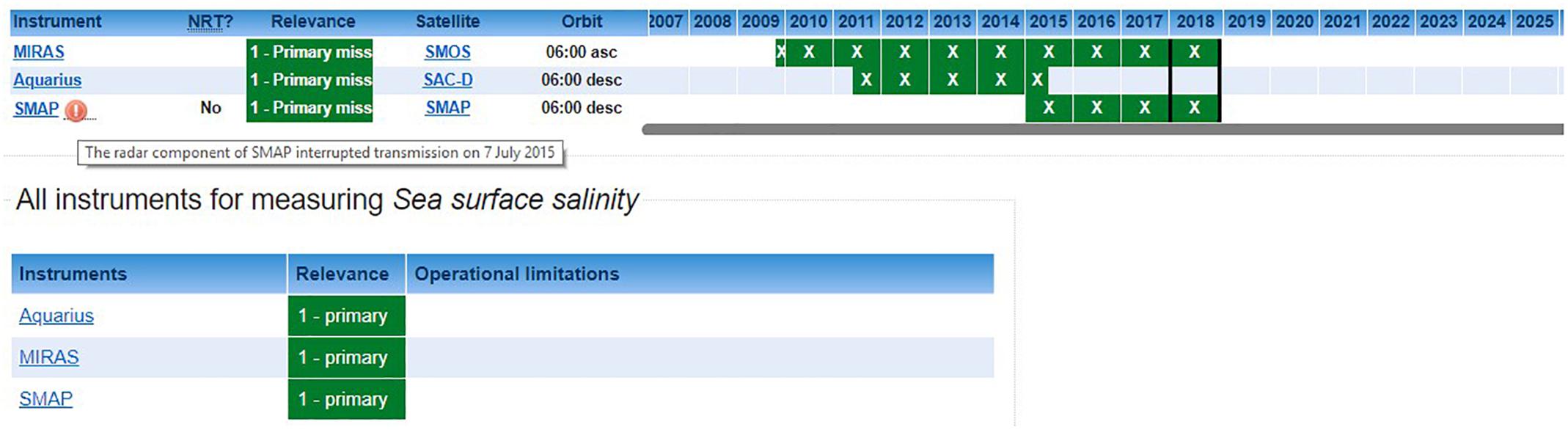
Figure 7. OSCAR/Space screen shot showing gap analysis for sea surface salinity.
OSCAR/Requirements
Understanding the various user requirements for observational data is fundamental to the design and evolution of an integrated observing system, and the OSCAR/Requirements database provides the official repository of quantitative and technology free observations user requirements in support of the WMO and co-sponsored programs. WMO has defined its application areas, a number of which require marine/ocean observations: climate monitoring (including reanalysis), climate science, global NWP, high resolution NWP, nowcasting and very short range forecasting, seasonal to longer predictions and ocean applications (including marine services), each with its own user requirements.
The database contains the observational user requirements for around 300 different geophysical variables expressed in terms of six criteria: horizontal resolution, vertical resolution, observing cycle (periodicity), timeliness, uncertainty and stability. For each of these criteria, three values are determined: goal (the ideal capability above which further improvements are not necessary); threshold (the minimum requirement to be met to ensure that data are useful); and breakthrough (an intermediate level between threshold and goal, which, if achieved, would result in a significant improvement for the relevant application).
Where multiple WMO application areas require observations of the same physical variable in the same domain, they generally have different requirements. The OSCAR/Requirements database contains technology-free requirements for each of the WMO application areas and is reviewed on a regular basis to ensure that it remains extant. Assessment of what is feasible compared with the requirements results in a gap analysis, which together with the results of impact studies and expert knowledge, forms the basis for “statements of guidance” for each application; these are concise summaries of the gaps and deficiencies in the current capability and inform decision makers toward the evolution of the observing system. A fourth foreseen component, OSCAR/analysis, a collection of tools and services to support the gap analysis, is still in its infancy.
At present, the status of the ocean observing system is assessed by the status of individual networks against network-based metrics, e.g., spatial coverage of Argo floats or drifting buoys. However, most users, and the above application areas, are primarily concerned with the availability of data on one (or more) variables, e.g., surface air pressure and SST for NWP, wind and waves for maritime operations and coastal flood protection, SST and sub-surface SST for monitoring ocean heat content. Hence, there is an effort under the JCOMM OCG to develop variable-based metrics, which will be related to the user requirements of the appropriate application areas as defined within OSCAR.
WDQMS
As noted earlier, the WDQMS will help assure end users that the observations are quality monitored, where problems are identified and addressed. It has three basic functions: quality monitoring, evaluation, and incident management. WDQMS will use OSCAR/Surface as the source of metadata that describes the expected accuracy of the observational data. It aims to provide information on availability, timeliness, and quality of observations to data providers enabling them to take corrective actions as necessary.
Traditionally for marine observations under the WMO GOS, designated WMO monitoring centers that run global NWP models undertake the quality monitoring. Quality monitoring reports, e.g., observation minus model background statistics for VOS and buoy data, for various marine meteorological variables (surface air temperature and humidity, surface air pressure, wind speed and direction, and SST) are routinely generated as a by-product of NWP data assimilation systems. The statistics are typically published monthly. This is possible because there are sufficient observational data to allow the NWP models to generate a dynamically consistent background field, against which the most recent surface observations can be assessed. This alerts operators to platforms or stations generating suspect observations, where they can investigate and take appropriate action (e.g., withholding the erroneous data from the GTS until the problem has been remedied).
However, this approach is not feasible for subsurface observations, where there are too few observations available to the ocean models to generate a sufficiently reliable background field. Instead, the observations are used to validate the model, rather than the model background field being used to assess the quality of the observations. However, for subsurface temperature and salinity profile data, standard real-time quality control tests have been developed under the Argo program, and these tests are also applied to other profile data (e.g., from ship-based CTD measurements and marine mammal-borne sensors) where these data are distributed in real-time (or near real-time). Similarly, quality control tests have been developed for dissolved oxygen and are being developed for other biogeochemical variables, which will ensure that any such data distributed on the WIS or available through network-based GDACs (Global Data Assembly Centers) is of a minimum quality. However, for climate and scientific applications the collected data are subjected to more stringent delayed-mode quality checks that can identify whether there are any sensor drifts or offsets that need to be corrected for.
Concluding Remarks and Recommendations
World Meteorological Organization Integrated Global Observing System is a “system of systems”, that provides a framework for all the WMO-sponsored and co- sponsored observing systems that encompasses in situ and remotely sensed observations, including those from GOOS. Integrating marine meteorological and oceanographic observations into the WIGOS is an essential activity that will lead to substantial benefits to the global meteorological community, as it will improve on the delivery of those data for use in a variety of application areas. Examples of these applications include the use of more sophisticated coupled ocean-atmosphere models for both shorter term weather forecasts and prediction of ocean hazards (tropical cyclones, storm surges, etc.) as well as for longer-term seasonal to climate predictions, and the provision of climate services under the GFCS. WIGOS will also be critical for climate monitoring; with the 2018 heat waves and other recent extremes, there is an enormous societal need to assess the current state of the climate against the climate of the recent past.
The benefits from WIGOS should not be restricted to the operational meteorological community. Many scientific studies require a range of ancillary data (i.e., in addition to that which is collected during research campaigns), and through the OSCAR tools, science users have the ability to interrogate the global data holdings across a wide range of domains to ensure that they can find and access the best available information. Hence, it is anticipated that WIGOS should benefit the entire global community that has a need for earth observation data. The “Vision for WIGOS in 2040” is presently being developed, envisaging how WMO members’ user requirements for observational data may evolve over the coming decades. The long-time horizon is partly driven by the planning and implementation timescales for satellite and weather radar replacement programs and to ensure the surface-based and space-based components are complementary. In response to the WIGOS Vision 2040, which is expected to be adopted by the eighteenth World Meteorological Congress in mid- 2019, WMO will then develop a WIGOS Implementation Plan with clear recommended actions and guidance to WMO members and partners to make WIGOS component observing systems evolve in the most effective way in response to Earth System prediction requirements.
However, as previously noted WIGOS is about much more than system/network integration and covers standards and best practices, interoperability, operations, design, partnerships, monitoring and incident management, capacity development and outreach, all of which are relevant for the evolution of GOOS over the coming decade, where many of these themes have been touched upon earlier in this paper.
The Way Ahead
Global Ocean Observing System now seeks to coordinate observations around the global ocean for three critical themes: climate, operational services, and marine ecosystem health. While much has been achieved since OceanObs’09, more needs to be done in the coming decade if GOOS is to realize its expanded vision and mission.
Within the context of the Framework for Ocean Observing, most of the effort to date has been focused on ‘inputs’ and ‘processes,’ i.e., setting requirements, specifying EOVs, improving observations coordination, and reinvigorating GRAs.
Focus now needs to shift to ‘outputs’ and ‘outcomes.’ The ocean observing system must clearly demonstrate and be widely recognized for its fundamental role underpinning the delivery of climate services, weather prediction, regional and global ocean assessments, fisheries management, ecosystem services, and real-time services.
In this paper, we have identified a field of opportunity for new collaborations to be formed— across regions, communities, and technologies. These include strengthened regional alliances, new observing networks, national ocean observing capabilities, in situ and satellite observations, and marine meteorology and oceanography.
To take advantage of these opportunities, this paper makes a number of suggestions and recommendations. Overall, the formal mechanisms of GOOS need to become more inclusive of ocean observing efforts relevant to its expanded vision and mission, and more creative in facilitating expansion and growth. This will require the formal mechanisms of GOOS to be adequately resourced.
Author Contributions
TM wrote the Section “The Changing Context for GOOS – From OceanObs’09 to OceanObs’19.” GN, CG, LG, ZW, ÁP, and TM wrote the Sections “Think Global, Act Local – Challenges and Opportunities in Collaborating Across GOOS Regional Alliances”, “The Need for New Observations and Biological and Coastal Data to Meet Expanded Requirements for GOOS”, and “Harnessing the Power of National Capabilities and Multinational Collaborations.” H-MZ, EB, DL, RL, CM, KOB, KS, AS, DZ, and YZ wrote the Section “GOOS as a Mechanism for Partnership Between Global Satellite and in situ Programs.” JT, SG, SB, EA, LR, CG, EC, MB, PP, and AR wrote the Section “Integrating Marine and Ocean Observations Into the Global Observing System.”
Conflict of Interest Statement
The authors declare that the research was conducted in the absence of any commercial or financial relationships that could be construed as a potential conflict of interest.
Acknowledgments
TM, GN, and CG acknowledge all other members of the GOOS Regional Alliance Council. At the initial responses to the OceanObs’19 call for CWP abstracts, the following people contributed to one or more abstracts that were eventually combined into the current CWP: Viva Banzon, Gary Corlett, Meghan Cronin, Paul DiGiacomo, and Boyin Huang.
Footnotes
- ^ https://unesdoc.unesco.org/ark:/48223/pf0000226859
- ^ http://www.ioc-unesco.org/index.php?option=com_oe&task=viewDocumentRecord&docID=22373
- ^ http://oceantrackingnetwork.org/
- ^ http://www.meop.net/
- ^ http://goa-on.org/
- ^ https://www.wmo-sat.info/oscar/satellites
- ^ https://eospso.nasa.gov/mission-category/3
- ^ http://biogeochemical-argo.org
- ^ https://www.wmo.int/pages/prog/www/wigos/tools.html
References
Amin, R., Lewis, M. D., Lawson, A., Gould, R. W. Jr., Martinolich, P., Li, R. R., et al. (2015). Comparative analysis of GOCI ocean color products. Sensors 15, 25703–25715. doi: 10.3390/s151025703
Anderson, D. (2010). “Early successes: El Nino, Southern oscillation and seasonal forecasting,” in Proceedings of OceanObs’09: Sustained Ocean Observations and Information for Society. (Venice).
Carse, F., Martin, M. J., Sellar, A., and Blockley, E. W. (2015). Impact of assimilating temperature and salinity measurements by animal-borne sensors on FOAM ocean model fields. Q. J. R. Meteorol. Soc. 141, 2934–2943. doi: 10.1002/qj.2613
Chatterjee, A., Gierach, M. M., Sutton, A. J., Feely, R. A., Crisp, D., Eldering, A., et al. (2017). Influence of El Niño on atmospheric CO2 over the tropical Pacific Ocean: findings from NASA’s OCO-2 mission. Science 358:eaam5776. doi: 10.1126/science.aam5776
Claustre, H., Bishop, J., Boss, E., Stewart, B., Berthon, J., Coatanoan, C., et al. (2009). “Bio-optical profiling floats as new observational tools for biogeochemical and ecosystem studies: potential synergies with ocean color remote sensing,” in Proceedings of the “OceanObs’09: Sustained Ocean Observations and Information for Society” Conference. eds J. Hall, D. Harrison, and D. Stammer (Venice).
Dash, P., Ignatov, A., Kihai, Y., and Sapper, J. (2010). The SST quality monitor (SQUAM). J. Atmos. Ocean. Technol. 27, 1899–1917. doi: 10.1175/2010jtecho756.1
Drinkwater, M., Kwok, R., Geiger, C., Maslanik, J., Fowler, C., and Emery, W. (1999). Ocean Observing System for Climate (OceanObs’ 99). Available at: http://www.oceanobs09.net/work/oo99.php
EuroGOOS (2018). Ocean Models: Catalogue of Existing Global, Regional and Coastal Ocean Models Generated from the GOOS Regional Alliances. Available at: http://eurogoos.eu/models (accessed October, 24 2018).
Feely, R., Takahashi, T., Wanninkhof, R., McPhaden, M., Cosca, C., Sutherland, S., et al. (2006). Decadal variability of the air-sea CO2 fluxes in the equatorial Pacific Ocean. J. Geophys. Res. Oceans 111:C08S90.
Fischer, A., and Willis, Z. (2013). Meeting Report of the Sixth Session of the GOOS Regional Alliance Forum (GRF-VI). Available at: http://ioc-goos.org/GRF-VI
Freeman, E., Woodruff, S. D., Worley, S. J., Lubker, S. J., Kent, E. C., Angel, W. E., et al. (2017). ICOADS release 3. 0: a major update to the historical marine climate record. Int. J. Climatol. 37, 2211–2232. doi: 10.1002/joc.4775
Geoghegan-Quinn, M., Fast, E., Jones, K., and Damanaki, M. (2013). Galway Statement on Atlantic Ocean Cooperation: Launching a European Union – Canada – United States of America Research Alliance. Available at: https:// ec.europa.eu/research/iscp/pdf/galway_statement_atlantic_ocean_cooperation .pdf
GOOS (2016). Report of the Fifth Meeting of the Global Ocean Observing System Steering Committee (GOOS SC-5). Toronto, ON: GOOS.
GOOS (2017). Meeting Report of the Eighth Session of the GOOS Regional Alliance Forum (GRF- VIII). Toronto, ON: GOOS.
GOOS (2018a). Global Ocean Observing System - Climate. Available at: http://www.goosocean.org/index.php?option = com_content&view = article&id = 3&Itemid = 103 (accessed October 24, 2018).
GOOS (2018b). Global Ocean Observing System - GOOS Regional Alliances (GRAs). Available at: http://www.goosocean.org/index.php?option = com_content&view = article&id = 83:regional- alliances-gras-2&catid = 24&Itemid = 121 (accessed October 24, 2018).
GOOS (2018c). Report of the Sixth Meeting of the Global Ocean Observing System Steering Committee (GOOS SC-6). Toronto, ON: GOOS.
Gruber, N., Doney, S., Emerson, S., Gilbert, D., Kobayashi, T., Körtzinger, A., et al. (2010). “Adding oxygen to Argo: developing a global in-situ observatory for ocean deoxygenation and biogeochemistry,” in Proceedings of OceanObs 9. (Venice).
Huang, B., Angel, W., Boyer, T., Cheng, L., Chepurin, G., Freeman, E., et al. (2018). Evaluating SST analyses with independent ocean profile observations. J. Climate 31, 5015–5030. doi: 10.1175/jcli-d-17-0824.1
Huang, B., Thorne, P. W., Banzon, V. F., Boyer, T., Chepurin, G., Lawrimore, J. H., et al. (2017). Extended reconstructed sea surface temperature, version 5 (ersstv5): upgrades, validations, and intercomparisons. J. Climate 30, 8179–8205. doi: 10.1175/jcli-d-16-0836.1
IOC-UNESCO (2013). GOOS Regional Policy 2013. Available at: https://unesdoc.unesco.org/ark:/48223/pf0000226859.
IOC-UNESCO (2015). Review of the GOOS Regional Alliances (GRA) Survey. Available at: http://www.ioc-unesco.org/index.php?option=com_oe&task=viewDocumentRecord&docID=22373
IOC-UNESCO (2018). Global Ocean Observing System - In Situ Networks. Available at: http://www.goosocean.org/index.php?option=com_content&view=article&id=24&Itemid=12 3
Jager, J., and Ferguson, H. (1991). “Climatic change: science, impacts and policy,” in Proceedings of the 2nd World Climate Conference, Geneva, October–November 1990. (Cambridge: Cambridge University Press).
JCOMM (2018). Observations Programme Area. Available: https://www.jcomm.info/index.php?option=com_content&view=article&id=338&Itemid=38 (accessed October 24, 2018).
Land, P., Bailey, T., Taberner, M., Pardo, S., Sathyendranath, S., Nejabati Zenouz, K., et al. (2018). A statistical modeling framework for characterising uncertainty in large datasets: application to ocean colour. Remote Sens. 10:695. doi: 10.3390/rs10050695
Landschützer, P., Gruber, N., and Bakker, D. C. E. (2016). Decadal variations and trends of the global ocean carbon sink. Glob. Biogeochem. Cycles 30, 1396–1417. doi: 10.1002/2015gb005359
Legler, D. M., and Hill, K. (2014). Tropical Pacific observing for the next decade: tropical pacific observing system (TPOS) 2020 Workshop La Jolla, California, 27–30 January 2014. Eos Trans. Am. Geophys. Union 95, 196–196. doi: 10.1002/2014EO230006
Lindstrom, E., Gunn, J., Fischer, A., McCurdy, A., and Glover, L. (2012). A Framework for Ocean Observing: A Report By the Task Team for an Integrated Framework for Sustained Ocean Observing. Paris: UNESCO.
Martin, M., Dash, P., Ignatov, A., Banzon, V., Beggs, H., Brasnett, B., et al. (2012). Group for high resolution sea surface temperature (GHRSST) analysis fields inter-comparisons. Part 1: a GHRSST multi-product ensemble (GMPE). Deep Sea Res. Part II Top. Stud. Oceanogr. 7, 21–30. doi: 10.1016/j.dsr2.2012.04.013
Martínez-Vicente, V., Evers-King, H., Roy, S., Kostadinov, T. S., Tarran, G. A., Graff, J. R., et al. (2017). Intercomparison of ocean color algorithms for picophytoplankton carbon in the ocean. Front. Mar. Sci. 4:378. doi: 10.3389/fmars.2017.00378
Maturi, E. M. (2010). “A new ultra high resolution sea surface temperature analysis from GOES-R ABI and NPOESS VIIRS,” in Proceedings of the 6th Annual Symposium on Future National Operational Environmental Satellite Systems-NPOESS and GOES-R). (Atlanta).
Miloslavich, P., Palacz, A., Lorenzoni, L., Sierra-Correa, P., Arias-Isaza, F., and Nolan, G. (2018). Report of the GOOS South American Regional Workshop: Regional projects and national strategies on marine monitoring. Available at: http://www.goosocean.org/index.php?option=com_oe&task=viewDocumentRecord&docID=22369
Moedas, C., Pandor, N., and Kassab, G. (2017). Belem Statement on Atlantic Research and Innovation Cooperation. Available at: https://ec.europa.eu/research/iscp/pdf/galway_statement_atlantic_ocean_cooperation.pdf
Reynolds, R. W., Rayner, N. A., Smith, T. M., Stokes, D. C., and Wang, W. (2002). An improved in situ and satellite SST analysis for climate. J. Climate 15, 1609–1625. doi: 10.1175/1520-04422002015<1609:Aiisas<2.0.Co;2
Rintoul, S., Speer, K., Sparrow, M., Meredith, M., Hofmann, E., Fahrbach, E., et al. (2010). “Southern ocean observing system (SOOS): rationale and strategy for sustained observations of the Southern Ocean,” in Proceedings of OceanObs ‘09: Sustained Ocean Observations and Information for Society. (Venice).
Smith, T. M., Reynolds, R. W., Peterson, T. C., and Lawrimore, J. (2008). Improvements to NOAA’s historical merged land–ocean surface temperature analysis (1880–2006). J. Climate 21, 2283–2296. doi: 10.1175/2007jcli2100.1
WMO (2013). WIGOS (WMO Integrated Global Observing System). Implementation Plan for the Evolution of Global Observing Systems (EGOS-IP). Geneva: WMO.
Xu, F., and Ignatov, A. (2014). In situ SST quality monitor (i Quam). J. Atmos. Ocean. Technol. 31, 164–180. doi: 10.1175/jtech-d-13-00121.1
Yang, W., John, V., Zhao, X., Lu, H., and Knapp, K. (2016). Satellite climate data records: development, applications, and societal benefits. Remote Sens. 8:331. doi: 10.3390/rs8040331
Zhang, H., Reynolds, R., and Bates, J. (2006). “Blended and gridded high resolution global sea surface wind speed and climatology from multiple satellites: 1987 - Present,” in Proceedimgs of the 86th AMS Annual Meeting. (Atlanta, CA).
Keywords: GOOS, GRAs, WIGOS, satellite, networks, coastal, data, national
Citation: Moltmann T, Turton J, Zhang H-M, Nolan G, Gouldman C, Griesbauer L, Willis Z, Piniella ÁM, Barrell S, Andersson E, Gallage C, Charpentier E, Belbeoch M, Poli P, Rea A, Burger EF, Legler DM, Lumpkin R, Meinig C, O’Brien K, Saha K, Sutton A, Zhang D and Zhang Y (2019) A Global Ocean Observing System (GOOS), Delivered Through Enhanced Collaboration Across Regions, Communities, and New Technologies. Front. Mar. Sci. 6:291. doi: 10.3389/fmars.2019.00291
Received: 31 October 2018; Accepted: 17 May 2019;
Published: 28 June 2019.
Edited by:
Laura Lorenzoni, University of South Florida, United StatesReviewed by:
Tong Lee, NASA Jet Propulsion Laboratory (JPL), United StatesKentaro Ando, Japan Agency for Marine-Earth Science and Technology, Japan
Copyright © 2019 Moltmann, Turton, Zhang, Nolan, Gouldman, Griesbauer, Willis, Piniella, Barrell, Andersson, Gallage, Charpentier, Belbeoch, Poli, Rea, Burger, Legler, Lumpkin, Meinig, O’Brien, Saha, Sutton, Zhang and Zhang. This is an open-access article distributed under the terms of the Creative Commons Attribution License (CC BY). The use, distribution or reproduction in other forums is permitted, provided the original author(s) and the copyright owner(s) are credited and that the original publication in this journal is cited, in accordance with accepted academic practice. No use, distribution or reproduction is permitted which does not comply with these terms.
*Correspondence: Tim Moltmannm, tim.moltmann@imos.org.au